The University of Arizona

edriesen's blog | CLIMAS


edriesen's blog

Monsoon Recap - October 2019

Wednesday, October 16, 2019

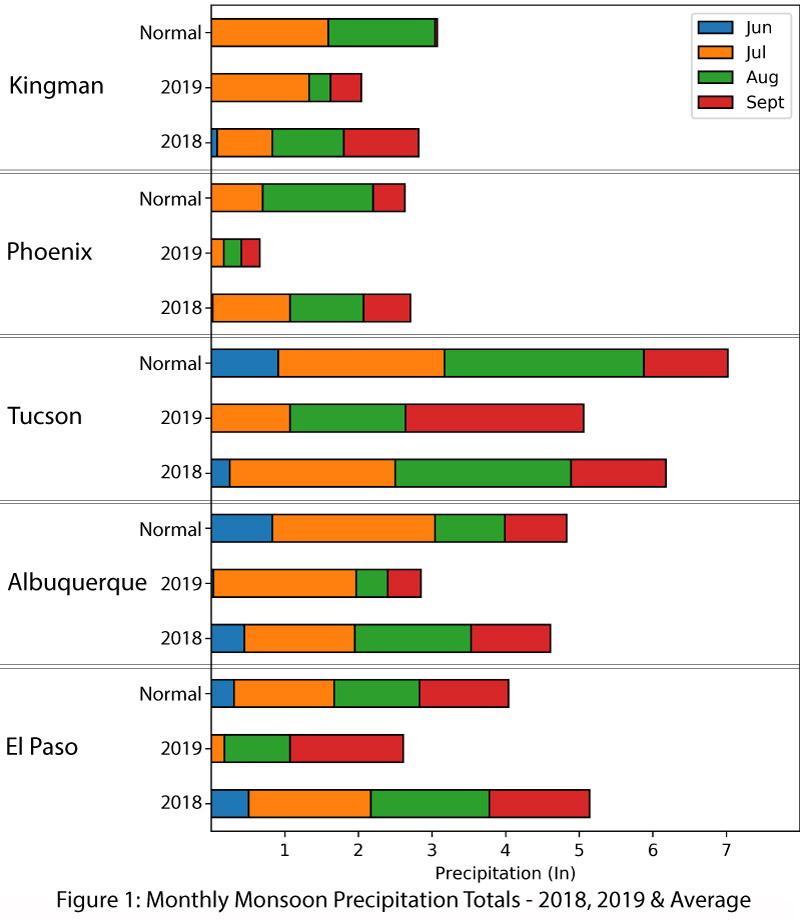
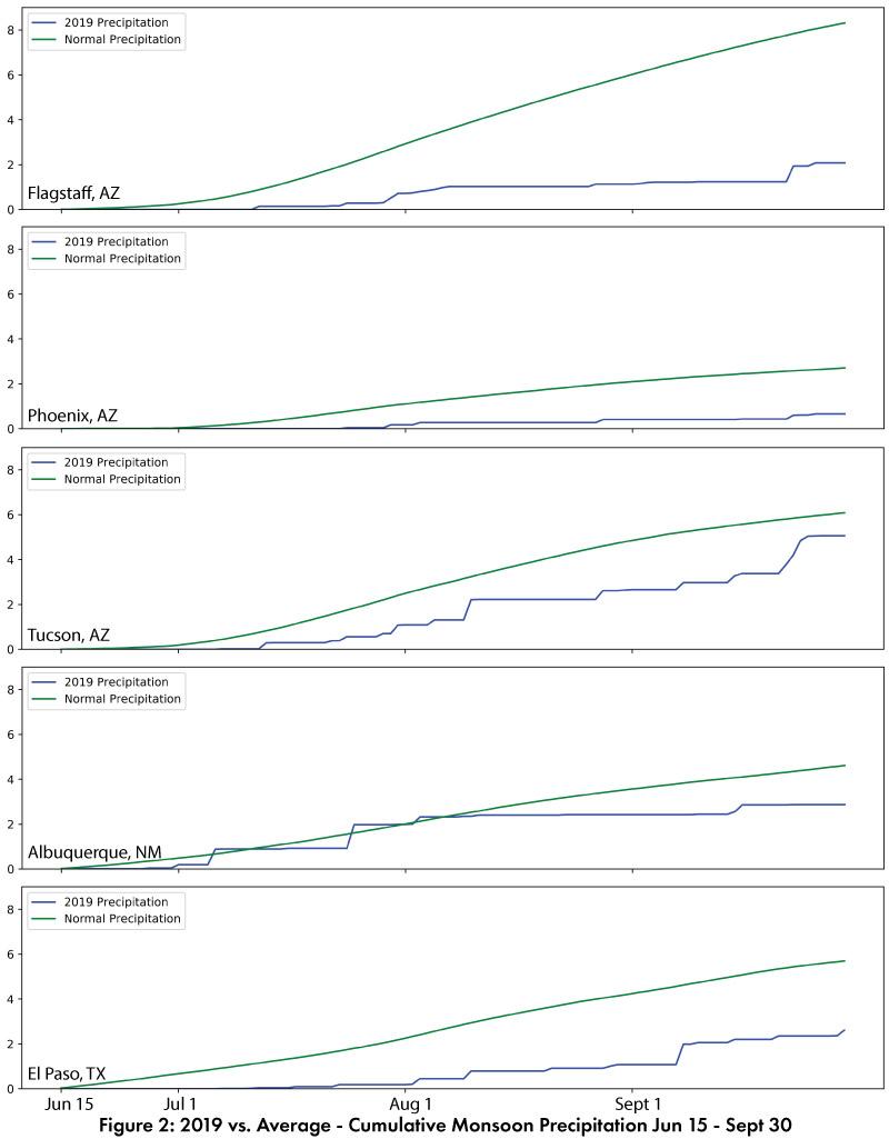
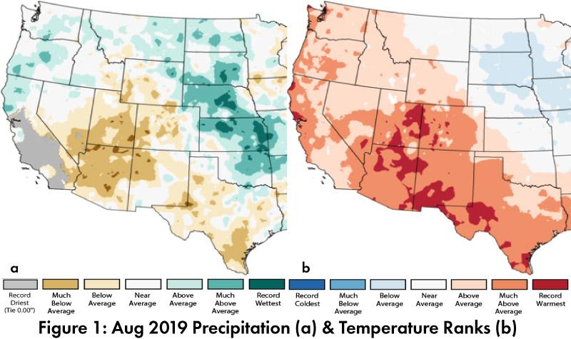
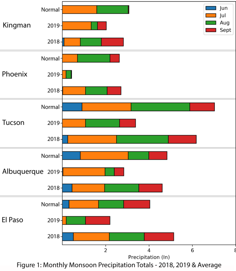
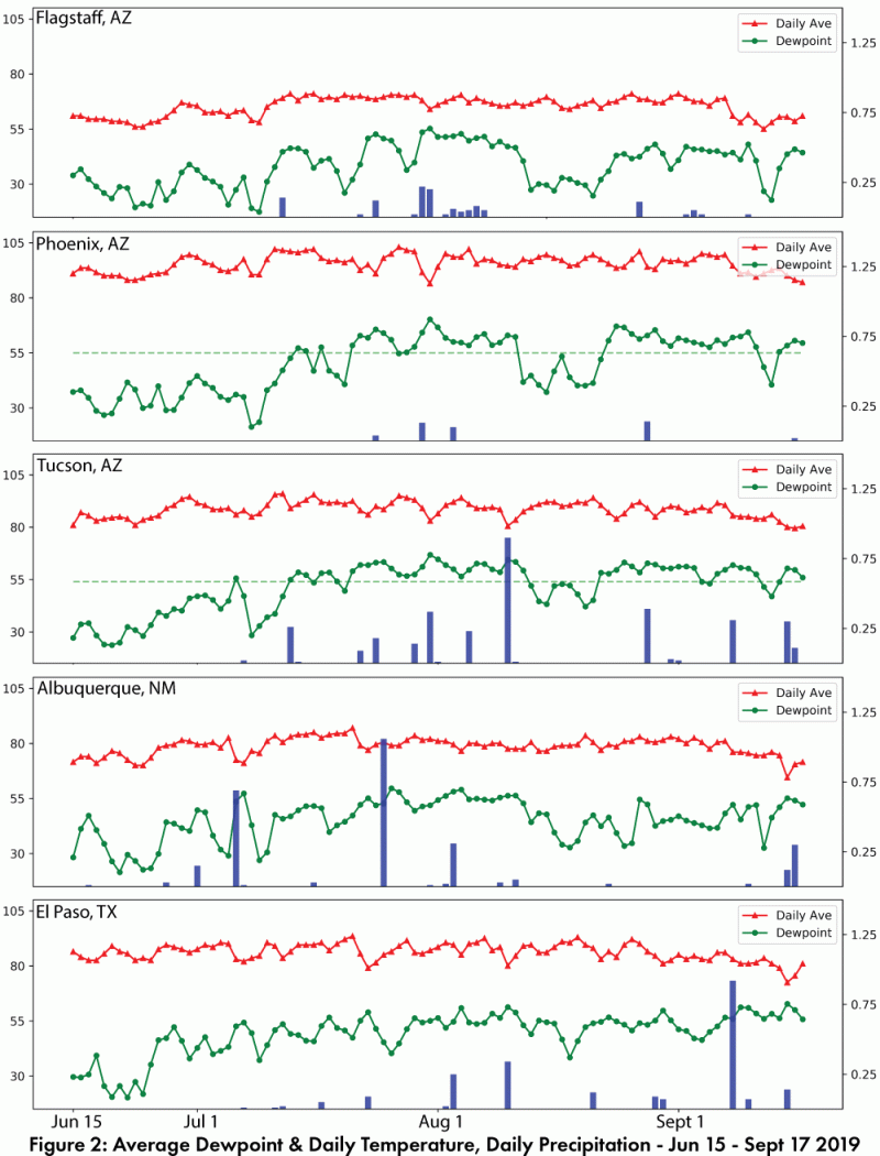
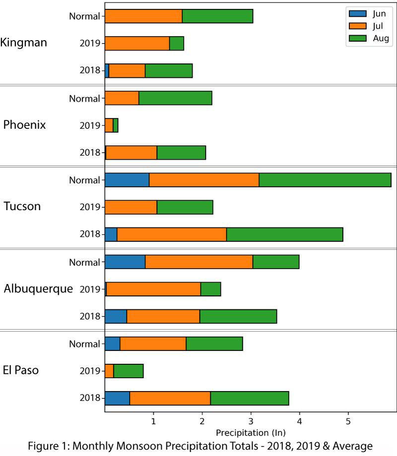
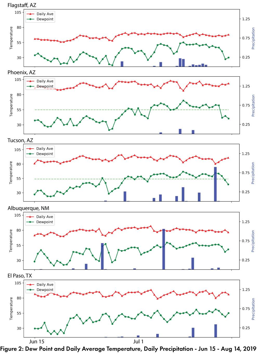
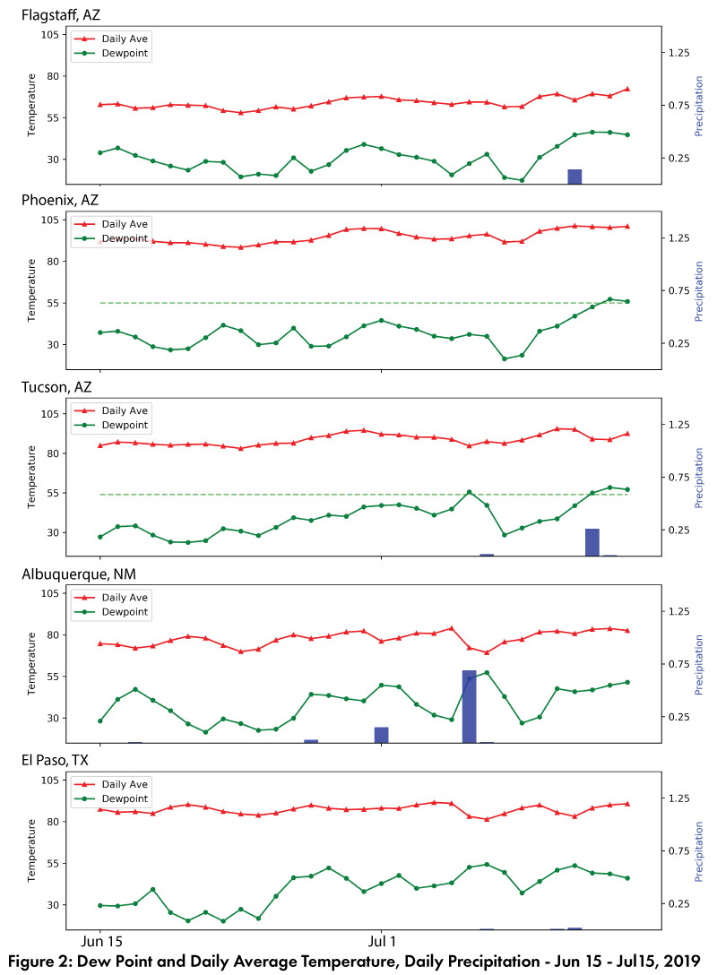
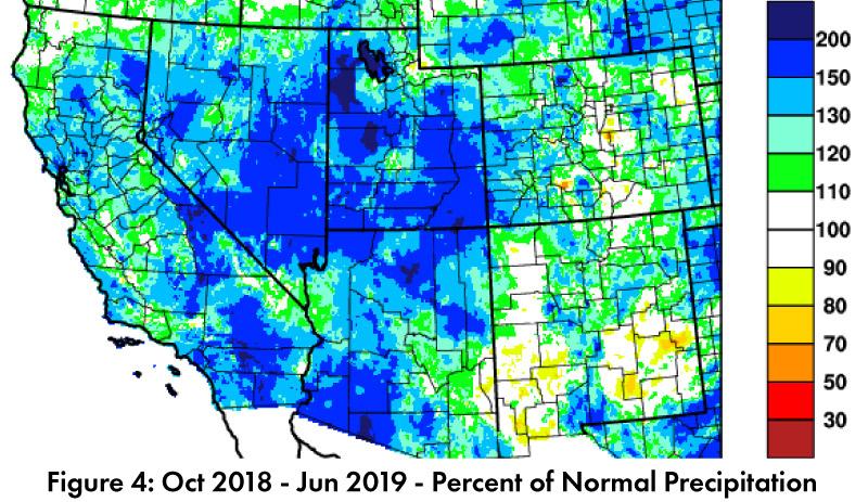
Single weather stations around the region are useful for comparing long term averages to the current year. Figure 1 summarizes monthly precipitation, and shows 2019 lagged behind 2018 and long term averages in most months at most locations. Plots of daily precipitation for stations around the region (Fig. 2) illustrate the slow start and lower than average totals across the region. This monsoon was notable in how much it deviated from the past few years, where many locations in the Southwest saw a run of above normal monsoon precipitation. This made 2019 particularly disappointing. A look at the long term averages demonstrates that 2019 is consistent with some of the drier monsoons on record, even while specific station locations were at or near record driest. (Read More)

Southwest Climate Outlook - El Niño Tracker - September 2019

Friday, September 20, 2019

Forecast Roundup: Seasonal outlooks and forecasts based on sea surface temperature (SST) anomalies (Figs. 1-2) and other oceanic and atmospheric indicators all point towards ENSO-neutral conditions lasting through 2019 and into 2020. On Sep 10, the Japanese Meteorological Agency (JMA) highlighted dissipating warmer-than-normal SSTs and maintained their call for a 60-percent chance of ENSO-neutral conditions to continue until winter 2019-2020. On Sep 12, the NOAA Climate Prediction Center (CPC) issued their ENSO diagnostic discussion, which focused on neutral conditions across the oceans and atmosphere. They called for a 75-percent chance of ENSO-neutral conditions persisting through fall 2019. On Sep 12, the International Research Institute (IRI) issued an ENSO Quick Look (Fig. 3), emphasizing neutral conditions in both oceanic and atmospheric ENSO indicators. Their models see ENSO-neutral as the most likely outcome, but with “slightly higher chances for El Niño than La Niña”. On Sep 17, the Australian Bureau of Meteorology maintained their ENSO Outlook at ‘inactive’ with most oceanic and atmospheric conditions in the range of neutral. The North American Multi-Model Ensemble (NMME) is within the range of ENSO-neutral and is forecast to remain neutral through 2019, with more variability and uncertainty into 2020 (Fig. 4). (Read More)

Southwest Climate Outlook September 2019 - Climate Summary

Friday, September 20, 2019

Monthly Precipitation and Temperature: August precipitation was much below average in most of Arizona, while most of New Mexico ranged from above average to much below average, and both states saw small pockets of record driest conditions (Fig. 1a). August temperatures were much above average to record warmest in Arizona and New Mexico (Fig. 1b). The daily average temperature anomalies for Aug 1 – Sep 17 highlight the fluctuations at select stations around the region (Fig. 2) (Read More).


Monsoon Recap - September 2019

Monday, September 16, 2019

Single weather stations are an imperfect measure of monsoon spatial variability, but they do provide an opportunity to track long term averages compared to the current year. Figure 1 compares 2019 precipitation to date with 2018 and climatology. This reveals 2019 is lagging behind average in terms of precipitation and is also a significant departure from 2018’s widespread activity that continued into September. Daily average and dewpoint temperatures, along with daily and cumulative precipitation illustrate that while increased dewpoint temperatures do not guarantee monsoon precipitation, it is rare to see monsoon precipitation in the absence of these elevated dewpoint temperatures (Fig. 2). (Read More)

Southwest Climate Outlook - El Niño Tracker - August 2019

Friday, August 23, 2019

Forecast Roundup: Seasonal outlooks and forecasts based on sea surface temperature (SST) anomalies (Figs. 1-2) and other oceanic and atmospheric indicators have all identified the end of this El Niño event. On Aug 6, the Australian Bureau of Meteorology maintained their ENSO Outlook at ‘inactive’, stating that “all climate models indicate the tropical Pacific is likely to remain ENSO-neutral for the rest of 2019”. On Aug 8, the NOAA Climate Prediction Center (CPC) issued their final El Niño advisory, which reflects the end of oceanic and atmospheric conditions indicative of El Niño. They called for a 50-55% chance of ENSO-neutral conditions persisting through winter 2019-2020. On Aug 8, the International Research Institute (IRI) issued an ENSO Quick Look (Fig. 3), confirming the end of El Niño as SSTs returned to normal in July. Their models see ENSO-neutral as the most likely outcome, but with “higher chances for El Niño than La Niña”. On Aug 9, the Japanese Meteorological Agency (JMA) highlighted a return to normal SSTs and other atmospheric indicators and maintained their call for a 60-percent chance of ENSO-neutral conditions to continue until winter 2019. The North American Multi-Model Ensemble (NMME) is within the range of ENSO-neutral and is forecast to remain there through 2019 and into 2020 (Fig. 4). (Read More)


Southwest Climate Outlook August 2019 - Climate Summary

Friday, August 23, 2019

Monthly Precipitation and Temperature: July precipitation was mostly below average to much below average in Arizona, while New Mexico ranged from above average to much below average (Fig. 1a). July temperatures were mostly above average to much above average in Arizona and New Mexico, with a small pocket of record warmest in southwestern New Mexico (Fig. 1b). The daily average temperature anomalies for Jul 1 – Aug 15 (Fig. 2) highlight the fluctuations at select stations around the region. (Read More)


Monsoon Recap - August 2019

Tuesday, August 20, 2019

Given the spatial variability of the monsoon, single weather stations are an imperfect measure, but they do provide an opportunity to track long term averages compared to the current year. Figure 1 compares 2019 precipitation to date with 2018 and climatology. This reveals 2019 is lagging behind average in terms of precipitation and is also a significant departure from 2018’s widespread activity by mid-August. Dewpoint temperatures and daily precipitation for the same five stations (Fig. 2) illustrate that while increased dewpoint temperatures do not guarantee monsoon precipitation, it is rare to see monsoon precipitation in the absence of these elevated dewpoint temperatures. Regional monsoon precipitation totals (Fig. 3) demonstrate variable precipitation in the Southwest, with much of the region lagging behind average accumulated precipitation through mid-July (Fig. 4). Percent of days with rain highlight areas with more regular rainfall events (Fig. 5). Mid-August is the approximate monsoon midpoint*, so there is time for below average areas to catch up, since a relatively late start does not necessarily mean decreased activity over the entire monsoon. (Read More)

Monsoon Recap - July 2019

Saturday, July 20, 2019

Given the spatial variability of the monsoon, single weather stations are an imperfect measure. For example, if it rains at the station and not in surrounding areas or vice versa. They do provide an opportunity to track long term averages compared to the current year. Figure 1 compares 2019 precipitation to date with 2018 and climatology. This reveals 2019 is lagging behind average in terms of precipitation and is also a significant departure from 2018's widespread activity by mid-July. Dewpoint temperatures and daily precipitation for the same five stations (Fig. 2) illustrate that while increased dewpoint temperatures do not guarantee monsoon precipitation, it is rare to see monsoon precipitation in the absence of these elevated dewpoint temperatures. (Read More)


Southwest Climate Outlook - El Niño Tracker - July 2019

Friday, July 19, 2019

Forecast Roundup: Seasonal outlooks and forecasts focused on sea surface temperature (SST) anomalies and other oceanic and atmospheric indicators, all of which had generally remained consistent with a weak El Niño event (Figs. 1-2), at least until recently. On July 9, the Australian Bureau of Meteorology ended their ENSO Outlook and returned to ‘inactive’ status, identifying ENSO-neutral as the most likely outcome in 2019. On July 10, the Japanese Meteorological Agency (JMA) identified the end of this El Niño event, mostly due to the rapid dissipation of SST anomalies, as well as the return to normal for other atmospheric indicators. They called for a 60-percent chance of ENSO-neutral conditions to continue into Fall 2019. On July 11, the NOAA Climate Prediction Center (CPC) maintained their El Niño advisory based on the SST anomalies, but trends in oceanic and atmospheric conditions led them to expect this event would transition to ENSO-neutral in the next few months. On July 11, the International Research Institute (IRI) issued an ENSO Quick Look (Fig. 3), highlighting above-average SSTs consistent with a weak El Niño, but with most models predicting a transition to ENSO-neutral status by the end of summer. The North American Multi-Model Ensemble (NMME) shifted considerably in the last month, and now points towards a rapid decline to ENSO-neutral status by early fall (Fig. 4). (Read More)


Southwest Climate Outlook July 2019 - Climate Summary

Friday, July 19, 2019

June Precipitation and Temperature Recap: June precipitation was variable in Arizona, ranging from record driest to above average, with a majority of the region recording average to below average precipitation, while New Mexico was mostly average with pockets of both below and above average precipitation (Fig. 1a). June temperatures were mostly average in Arizona and New Mexico, with pockets of above and below average temperatures (Fig. 1b). Daily average temperature anomalies for Jun 1 – Jul 15 demonstrate the fluctuations above and below average (Fig. 2). (Read More)


Pages

Subscribe to RSS - edriesen's blog