Southwest Climate Outlook September 2019 - Climate Summary
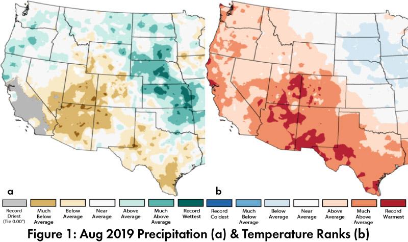
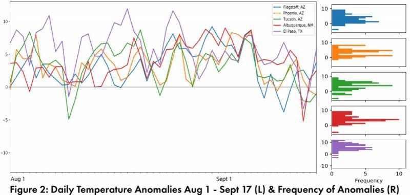
Monthly Precipitation and Temperature: August precipitation was much below average in most of Arizona, while most of New Mexico ranged from above average to much below average, and both states saw small pockets of record driest conditions (Fig. 1a). August temperatures were much above average to record warmest in Arizona and New Mexico (Fig. 1b). The daily average temperature anomalies for Aug 1 – Sep 17 highlight the fluctuations at select stations around the region (Fig. 2).
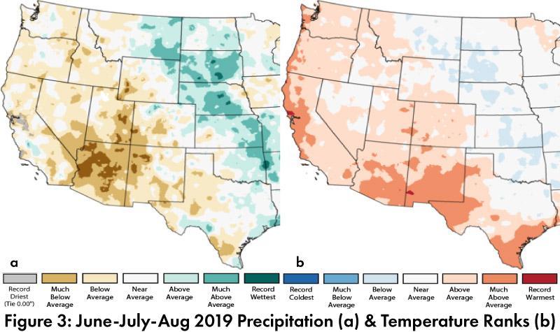
Seasonal Precipitation and Temperature: Total precipitation for the last three months (June-August) was below average to record driest in Arizona, with a wide range of above and below average totals in New Mexico (Fig. 3a). Mean temperatures for the same three-month period were above average to much above average across the region (Fig. 3b).
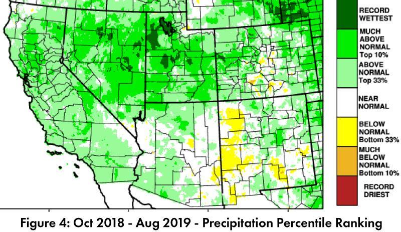
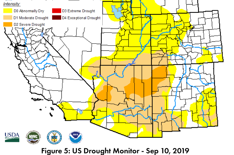
Drought: Water year precipitation to date includes wetter than normal winter conditions, and only pockets of Arizona, and much of western and southern New Mexico recorded below normal precipitation in the Southwest (Fig. 4). The recent downturn in precipitation activity is reflected in the Sept 10 U.S. Drought Monitor (USDM), which has seen a return of widespread drought designations in Arizona and western New Mexico (Fig. 5).
Water Supply: Most of the reservoirs in the region are at or above the values recorded at this time last year, but most also remain below their long-term average (see Arizona and New Mexico reservoir storage). There have been improvements over the last year, but concerns remain about the recent below average precipitation, along with the accumulated water resource deficits associated with multiple years of drought.
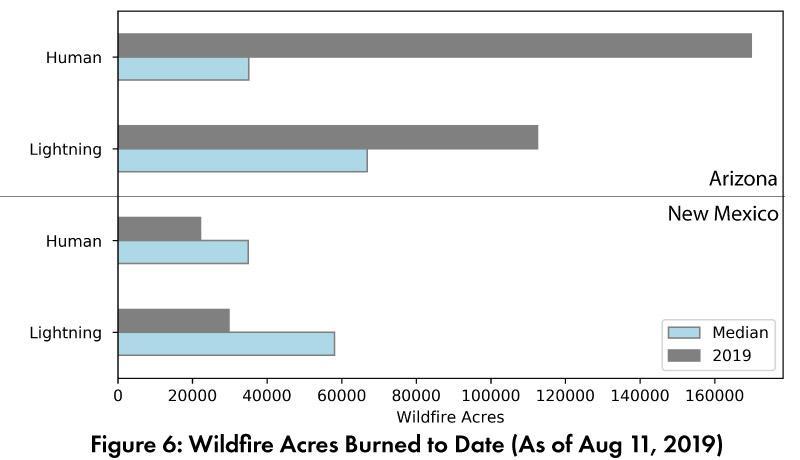
Wildfire, Health, and Safety: The National Interagency Fire Center outlooks for September, October, and November all call for average fire risk across the region. With the declining monsoon activity and cooling temperatures, the Southwest should be on the wane for fire activity. Current seasonal statistics for wildfire acres burned show that lightning and human caused fires are above median in Arizona, and below median in New Mexico (Fig. 6).
ENSO Tracker: Oceanic and atmospheric conditions are generally consistent with an ENSO-neutral outlook for 2019 and into 2020 (see ENSO-tracker for details).
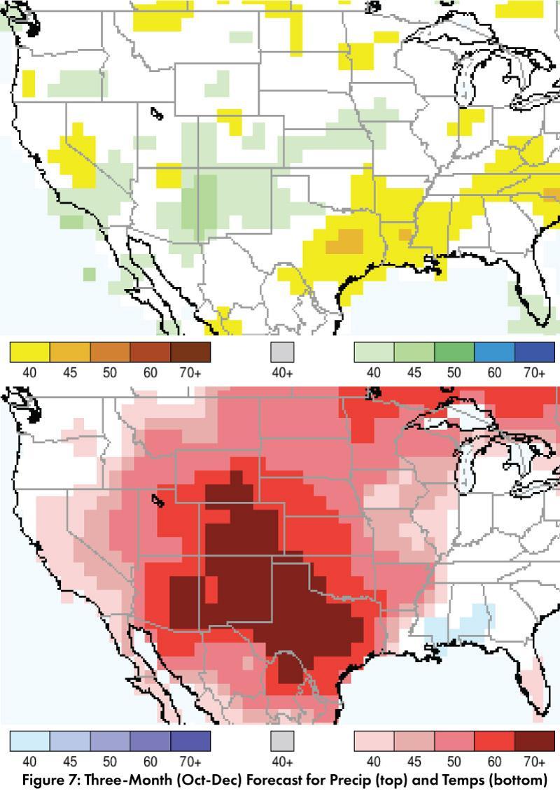
Precipitation and Temperature Forecast: The three-month outlook for October through December calls for increased chances of above-normal precipitation in much of New Mexico, eastern Arizona, and north Texas, while equal chances of above- or below-normal precipitation are prominent in western Arizona, west Texas, and most of northern Mexico (Fig. 7, top). The three-month temperature outlook calls for increased chances of above-normal temperatures across the U.S. Southwest and northern Mexico (Fig. 7, bottom).
Online Resources
- Figures 1 - National Centers for Environmental Information - ncei.noaa.gov
- Figure 2, 6 - Climate Assessment for the Southwest - climas.arizona.edu
- Figure 3, 4 - Western Regional Climate Center - wrcc.dri.edu
- Figure 5 - U.S. Drought Monitor - droughtmonitor.unl.edu
- Figure 7 - International Research Institute for Climate and Society - iri.columbia.edu

