The University of Arizona

Monthly Archive | CLIMAS

Monthly Archive

Nov 2016 La Niña Tracker

Thursday, December 22, 2016

From the November issue of the CLIMAS Southwest Climate Outlook

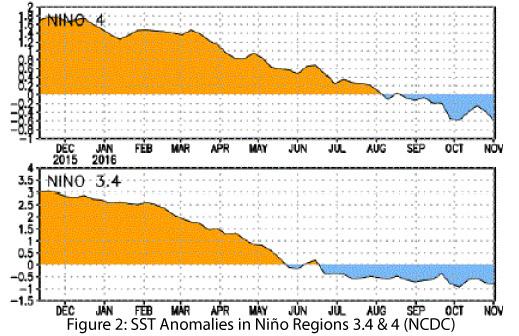
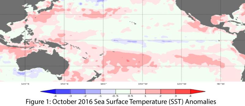
Oceanic and atmospheric indicators of the El Niño-Southern Oscillation (ENSO) continue to indicate the likelihood of a weak La Niña event this winter (Figs. 1-2), although the chance of an ENSO-neutral winter cannot be ruled out. Any hedging in the forecasts and outlooks likely stems from uncertainty as to whether the event will maintain even weak La Niña strength through winter 2017 (December–February). Fluctuations in forecasts and models are likely due to the limited coordination between oceanic and atmospheric conditions described in previous outlooks, as well as generally borderline conditions (i.e., between weak La Niña and ENSO-neutral).

read more

2016 Water Year in Review

Sunday, November 20, 2016

From the November issue of the CLIMAS Southwest Climate Outlook

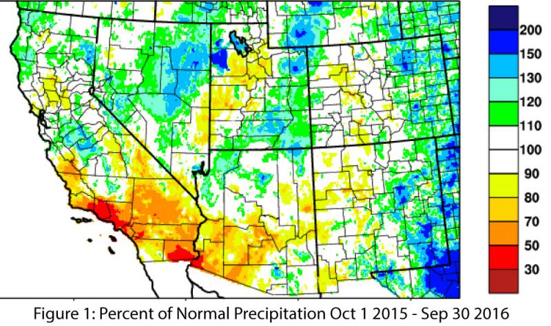
Water year precipitation (October 1, 2015 to September 30, 2016) was below average in much of the Southwest, particularly in Southern California, most of southern Arizona, and western New Mexico, and average to above average in northern Arizona and eastern New Mexico (Fig. 1). Spatial representations of cumulative water year precipitation adequately characterize the overall distribution of above- and below-average precipitation totals, but they do little to document the month-by-month accumulation of precipitation. This can be important, as heavy precipitation events such as tropical storm activity or monsoon events can quickly boost yearly totals, but with a lesser contribution to long-term water storage (as water from extreme events is lost to evaporation and runoff).

read more

Nov 2016 CLIMAS Southwest Climate Outlook - Climate Summary

Friday, November 18, 2016

From the November issue of the CLIMAS Southwest Climate Outlook

Precipitation & Temperature: October precipitation totals were below average across most of the climate divisions in Arizona and New Mexico, except for parts of western Arizona and central New Mexico (Fig. 1a). October temperatures were much above average across all of the two states, with record-warm observations in southern and eastern New Mexico (Fig. 1b). November precipitation to date has been buoyed by storm events that pushed in as part of a cutoff low. This rainfall may boost the percent of average precipitation calculations to impressive numbers, but the actual amount of rain that has fallen has been relatively meager (Fig. 2). In terms of regional climate, November tends to be one of the drier months. November temperatures have continued the trend observed in October (“Hot-tober”), ranging from 2 to 8 degrees F above normal across most of Arizona and New Mexico, a pattern that extends across the Intermountain West (Fig. 3).

read more