The University of Arizona

Category | CLIMAS

Category

SWCO Aug 2016 - La Niña Tracker

Friday, August 19, 2016

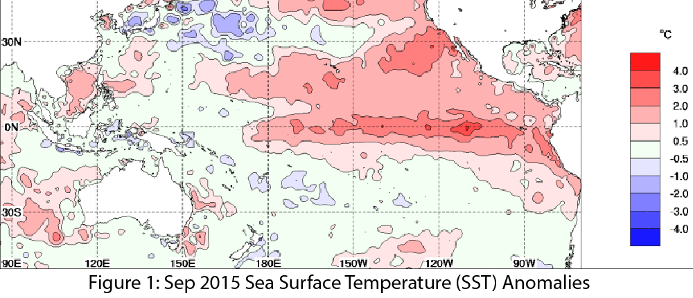
Oceanic and atmospheric indicators of the El Niño-Southern Oscillation (ENSO) remain in the range of neutral conditions (Figs. 1-2). Seasonal forecasts and models identify the most likely scenario being a weak La Niña event forming sometime in late summer or fall 2016 and lasting through winter 2017. Some uncertainty exists regarding the specific timing of this event, as the equatorial sea surface temperature (SST) anomalies have not yet dropped into La Niña range and there is a lack of coordination between ocean and atmosphere (and in particular the lack of enhanced trade winds). (read more)

El Niño Recap & La Niña Outlook - May 2016

Saturday, May 21, 2016

El Niño Recap & La Niña Outlook

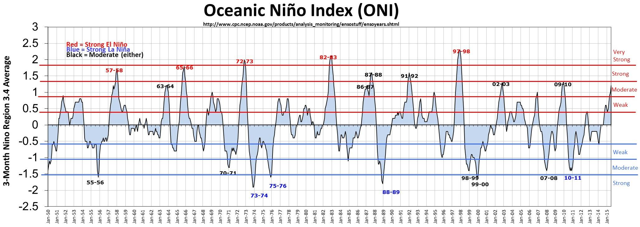
This El Niño event was one of the strongest ever recorded (Fig. 5), and if past performance was any indication of what was expected for the Southwest, the region should have seen above-average precipitation over much of the cool season (winter and spring). The Southwest generally saw lower-than-expected precipitation totals that were much closer to average, or even below average in some cases.  There are several reasons why this event did not meet expectations. (read more)
El Niño Tracker - May 2016

Friday, May 20, 2016

El Niño conditions continued for a 15th straight month, but the peak intensity has long since passed and the event is moving toward ENSO-neutral status. Forecast discussions focused on the decline of atmospheric and oceanic anomalies that characterize an El Niño event, many of which are trending towards—or have nearly reached—ENSO-neutral status. (read more)
El Niño Tracker - March 2016 - Time Winding Down for El Niño in the Southwest

Friday, March 18, 2016

Originally published in the Mar 2016 CLIMAS Southwest Climate Outlook

El Niño conditions continued for a 13th straight month, but the peak of this event has passed. Monitoring and forecast discussions emphasize strong positive sea surface temperature (SST) anomalies (Figs. 1–2) and enhanced convective activity in the central and eastern Pacific. These positive temperature anomalies are waning, and trade wind activity is increasing, indications that this El Niño event is on the decline. Most forecasts emphasize this event will continue through spring or early summer before returning to ENSO-neutral status. (read more)
2015-2016 El Niño Tracker - Feb 2016

Monday, February 22, 2016

El Niño conditions continued for a 12th straight month, but we have passed the peak intensity of one of the strongest El Niño events on record. This does not mean that El Niño is over, though. Despite the recent warm and dry conditions in the Southwest, we are likely to see more weather events associated with El Niño conditions through spring 2016. (read more)
¿Cómo se determina la fuerza de El Niño?

Tuesday, February 2, 2016

Existen varios índices o indicadores para seguir el desarrollo de ENSO (La Circulación del Sur El Niño) a través del Océano Pacifico y para determinar si los patrones atmosféricos reflejan las condiciones típicas de El Niño, La Niña, o condiciones neutrales. (lee mas)

El Niño Tracker - Jan 2016

Friday, January 22, 2016

El Niño conditions continued for an 11th straight month, putting us squarely in the middle of a strong El Niño event that will be among one of the strongest events on record. Forecasts focused on the persistence of sea surface temperature (SST) anomalies (Figs. 1–2) and weakened trade winds, enhanced convective activity in the central and eastern Pacific, and El Niño-related ocean-atmosphere coupling. Models continue to forecast a strong El Niño event that will last through spring 2016, but we are starting to see signs of decline in the overall strength of the event. (read more)
El Niño and Media Coverage in the Southwest

Friday, December 18, 2015

What do wildflowers, hantavirus, downhill skiing, locusts, and floods all have in common? The answer is El Niño in the Southwest. These subjects represent a small sample of media stories written during the last 33 years that connect regional impacts to the El Niño phase of the El Niño-Southern Oscillation (ENSO) and help illustrate an evolution in our understanding of the significance of El Niño to the region. (read more)
El Niño Tracker - Dec 2015

Friday, December 18, 2015

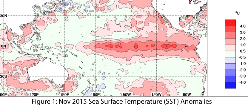
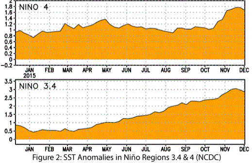
El Niño conditions continued for a 10th straight month, and models continue to forecast a strong El Niño event that will last through spring 2016 and remain strong through the early part of the year. Forecasts focused on the persistence of sea surface temperature (SST) anomalies (Figs. 1–2) and weakened trade winds, enhanced convective activity in the central and eastern Pacific, and El Niño-related ocean-atmosphere coupling. Notably, the SST values in the Niño 3.4 region were at or above the record values in November. Climate scientists have been quick to point out that numerous factors contribute to the overall strength of El Niño, but we are certainly seeing one of the strongest events on record. (read more)
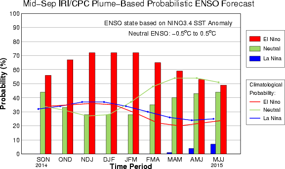
Image Source - Australian Bureau of Meteorology

Image Source - NOAA/NWS - Climate Prediction Center

2015 - Eastern Pacific Tropical Storm Recap

Friday, December 18, 2015

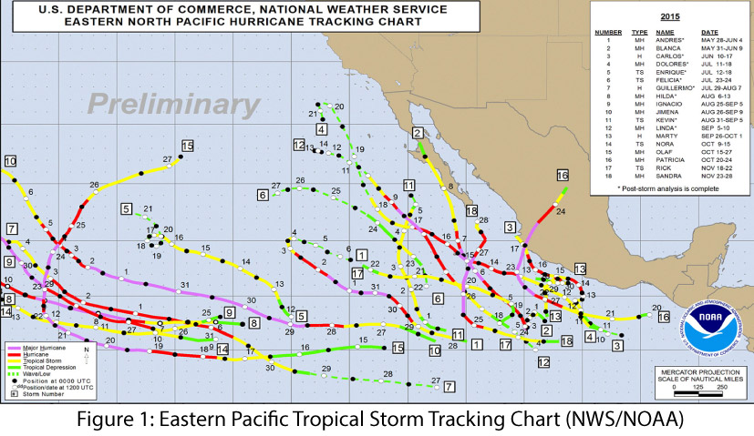
The 2015 eastern Pacific tropical storm season was one of the most active seasons on record, with 18 named storms and 13 hurricanes, nine of which reached “major” hurricane status (category 3 or greater). We also saw the strongest hurricane on record, Patricia, in the eastern Pacific in late October, and the latest-forming major hurricane on record, Sandra, in late November (see NOAA’s National Hurricane Center for more details). This meets or exceeds the high end of the NOAA-Climate Prediction Center (CPC) seasonal forecast (from May 27), which predicted 15 to 22 named storms, seven to 12 hurricanes, and five to eight major hurricanes. The eastern Pacific hurricane forecast was tied to the ongoing El Niño forecast discussion, as conditions linked to El Niño (e.g., decreased wind shear in the tropical Pacific) also favored increased hurricane frequency and intensity in the Pacific region. (read more)
El Niño Tracker - Nov 2015

Saturday, November 21, 2015

Originally published as part of the Nov 2015 CLIMAS Southwest Climate Outlook

El Niño conditions continued for a ninth straight month, and models continue to forecast a strong El Niño event that likely will last through spring 2016 and remain strong through the early part of the year. Forecasts focused on the persistence of sea-surface temperature (SST) anomalies (Figs.1–2) and weakened trade winds, enhanced convective activity in the central and eastern Pacific, and El Niño-related ocean-atmosphere coupling. (read more)

Image Source - Australian Bureau of Meteorology

El Niño Tracker - Oct 2015

Thursday, October 15, 2015

Originally published in the Oct 2015 CLIMAS Southwest Climate Outlook

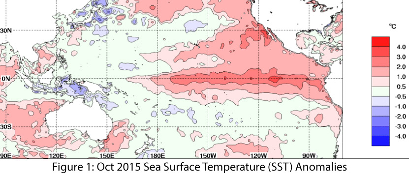
We spent the better part of 2014 (and the first part of 2015) waiting in anticipation for an El Niño event that was initially forecast to be one of the stronger events on record. By early 2015, the event in question had not yet materialized, and some questioned whether El Niño would ever arrive. Eventually it did, and has been going strong for months, with most forecasts indicating that it will remain a strong event through the winter. (read more)
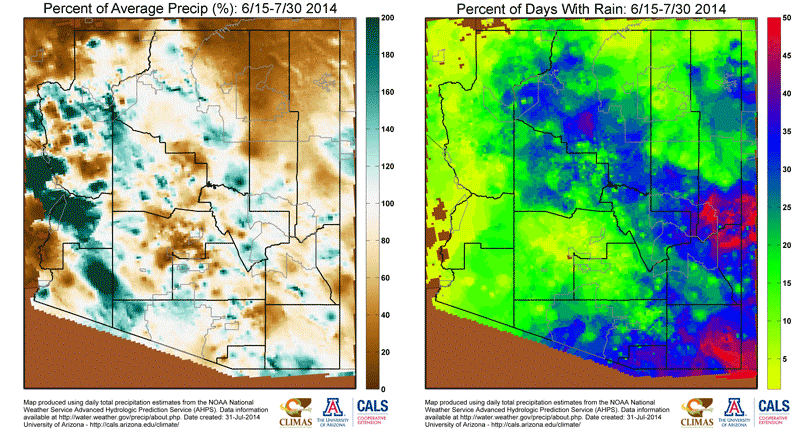
Image Source - Australian Bureau of Meteorology

El Niño is here…what exactly does that mean for Arizona and New Mexico?

Thursday, September 24, 2015

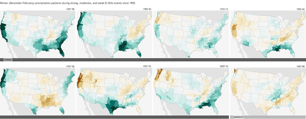
“El Niño” has been all over the news lately, even garnering comparisons to a Godzilla – a prehistoric sea monster awakened and empowered by nuclear radiation (thank you Wikipedia). This characterization is in response to the near record strength of this El Niño event, which is exciting for climate enthusiasts, but leaves most people wondering; what does a strong El Niño event actually mean for Arizona and New Mexico? Are we talking floods? Droughts?  Plagues of locusts? Additionally, how soon can we expect this “El Niño” character to show up?  In other words, what does a realistic assessment look like? (read more)

El Niño Tracker - September 2015

Friday, September 18, 2015

El Niño conditions continued for a seventh straight month, and forecasts and models indicate this event likely will last through spring 2016, remaining strong through the early part of the year. Forecasts focused on the persistence of sea-surface temperature (SST) anomalies (Figs.1–2) and weakened trade winds, ongoing convective activity in the central and eastern Pacific, and El Niño-related ocean-atmosphere coupling. (read more)

El Niño Tracker - August 2015

Friday, August 21, 2015

Originally published in the August 2015 CLIMAS Southwest Climate Outlook

El Niño conditions continued for a sixth straight month and forecasts and the most recent outlooks offer a consistent cluster of forecasts calling for a clear El Niño signal similar to past strong events, lasting into early 2016. Forecasts focused on the persistence of sea-surface temperature (SST) anomalies (Figs.1–2) and on weakened trade winds, ongoing convective activity in the central and eastern Pacific, and El Niño-related ocean-atmosphere coupling. (read more)

Image Source - Australian Bureau of Meteorology

El Niño Tracker - July 2015

Monday, July 20, 2015

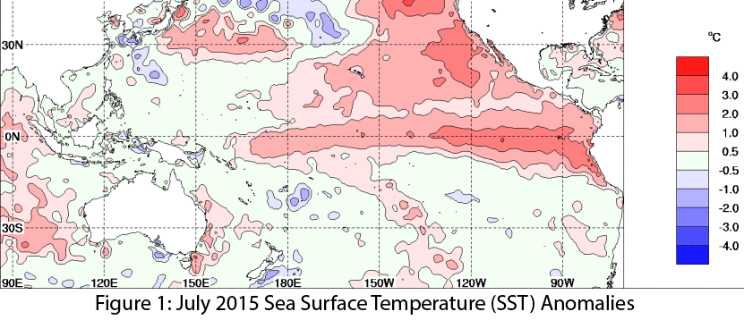
El Niño conditions continue for a fifth straight month, and at this point, forecasters are relatively bullish that we are witnessing the development of a moderate-to-strong event that could rival 1997 in absolute magnitude later this year. The most recent outlooks from various sources offer a consistent cluster of forecasts calling for a clear El Niño signal that is maintained or even strengthens well into early 2016. Forecasts focused on the persistence of sea-surface temperature (SST) anomalies (Figs.1 - 2) along with weakening trade winds, ongoing convective activity in the central and eastern Pacific, and El Niño-related ocean-atmosphere coupling. (read more)

Image Source - Australian Bureau of Meteorology

El Niño Tracker - June 2015

Friday, June 19, 2015

Originally Published in the June 2015 CLIMAS SW Climate Outlook (SWCO)


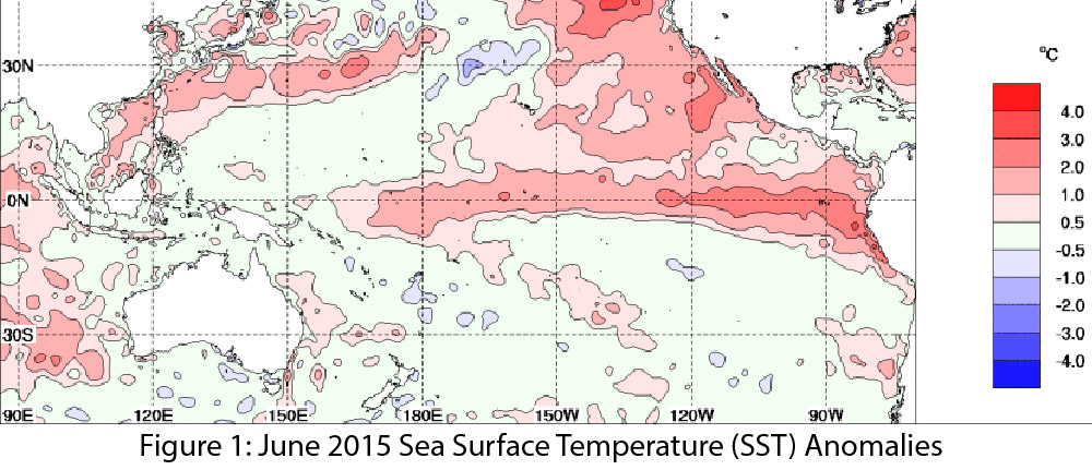
El Niño conditions continued for a fourth straight month with no signs of weakening or disorganizing. Forecasts focused on the persistence of sea-surface temperature (SST) anomalies (Figs.1 - 2) along with weakening trade winds, ongoing convective activity, and El Niño-related ocean-atmosphere coupling. Despite the high degree of uncertainty associated with forecasting El Niño this time of year (the so-called spring predictability barrier), the most recent outlooks from various sources offer a consistent cluster of forecasts calling for a clear El Niño signal that is maintained or even strengthening. (read more)


Image Source - Australian Bureau of Meteorology

2015 El Niño Tracker

Friday, May 22, 2015

Originally published in the May 2015 CLIMAS SW Climate Outlook


El Niño continued for a third straight month, with no signs of weakening or dissipating. Forecasts keyed in on persistent sea surface temperature (SST) anomalies (Figs. 1–2), along with weakening trade winds, ongoing convective activity, and El Niño-related ocean-atmosphere coupling. If these conditions continue, we are likely to see the effects of a moderate El Niño event–or stronger if conditions continue to strengthen. Spring forecasts have a higher degree of uncertainty, owing to the so-called spring predictability barrier, a likely source of vacillations in recent forecasts. (read more)

Image Source - Australian Bureau of Meteorology

El Niño Tracker - April 2015

Friday, April 17, 2015

This was originally published in the April 2015 Southwest Climate Outlook


Strong signals in early 2014 stalled, delaying El Niño’s onset until last month, when ocean-atmosphere coupling and an additional Kelvin wave indicated more favorable conditions. Despite this late start, El Niño continued for a second consecutive month. Recent increases in sea surface temperature (SST) anomalies (Fig.1 - 2) and ongoing convective activity associated with El Niño-favorable conditions indicate we might be witnessing a two-year El Niño event. These forecasts rely on projections during a time of increasing uncertainty, and the so-called “spring predictability barrier” continues to make it difficult to anticipate how seasonal changes will help or hinder El Niño. (read more)

El Niño Tracker - Southwest Climate Outlook February 2015

Friday, February 20, 2015

Originally published in the Feb 2015 CLIMAS Southwest Climate Outlook

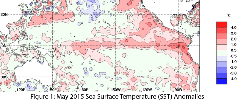
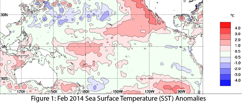
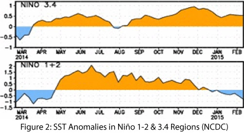
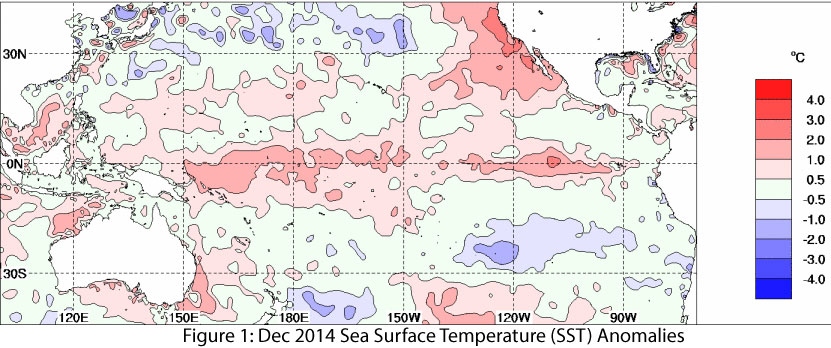
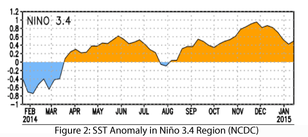
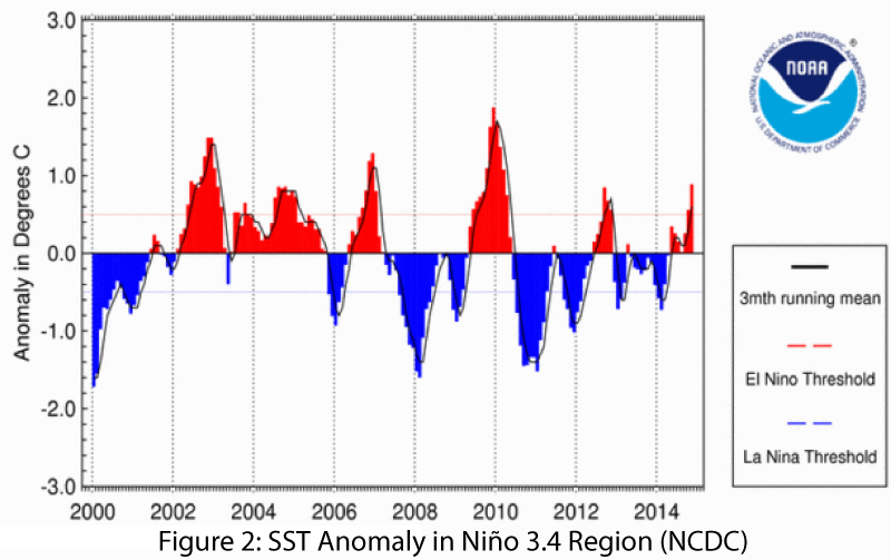
A definitive 2014–2015 El Niño forecast remains elusive. Weak El Niño conditions have continued in 2015, but recent backsliding in SST anomalies (Fig. 1), especially in the Niño 1-2 regions (Fig. 2), along with the ongoing lack of coordination between atmospheric and oceanic conditions, give little confidence that the 2014–2015 event will be characterized as anything more than a weak El Niño. (read more)

Image Source - NOAA-National Climatic Data Center

El Niño Tracker - January 2015

Friday, January 23, 2015

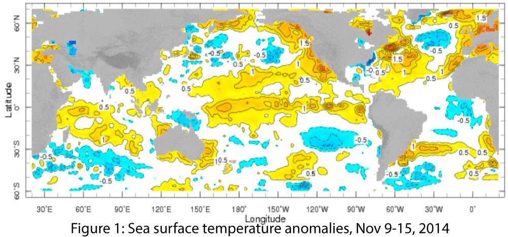
Just when it looked like we were getting a more definitive answer regarding El Niño, ongoing lack of cooperation on the part of the atmosphere continues to muddy forecasts moving into 2015. Sea surface temperatures (SSTs) remain elevated across much of the equatorial Pacific Ocean (Fig. 1), and while temperature anomalies in the Niño 3.4 region are within the range of a weak El Niño event, they have declined in the past month (Fig. 2). It is a common refrain in forecast bulletins that a lack of coupling between ocean and atmosphere is responsible for decreased confidence in an El Niño event this winter. Additionally, a lack of temperature gradient along the equatorial Pacific and little in the way of El Niño wind patterns further reduce confidence that a stronger event is on the horizon. (read more)

El Niño Tracker Update - Late November 2014

Friday, November 21, 2014

From the Nov 20, 2014 Southwest Climate Outlook

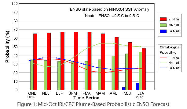
The long-awaited El Niño event projected to develop during winter 2014 – 2015 has yet to send a decisive signal regarding an official start, but a number of factors have increased forecasters’ confidence that one will emerge. The strength of this event still remains in question, however with the most likely projection still centering on a weak or weak to moderate event (

2014/2015 El Niño Tracker: Oct 16, 2014

Thursday, October 16, 2014

An El Niño Watch, issued by the NOAA Climate Prediction Center (CPC), continues for the seventh consecutive month as signs of an emerging El Niño are just on the horizon, but not quite here yet. Another slug of warm water (also known as a Kelvin wave), has been making its way across the Pacific Ocean from west to east just below the surface and is poised to emerge and help warm sea surface temperatures in the eastern Pacific over the next month or so...(read more)

This post was originally published as part of the October 2014 Southwest Climate Outlook

El Niño Tracker - Sept 2014

Thursday, September 18, 2014

The song remains the same this month with El Niño not quite here yet, but probably soon. This is now the seventh consecutive month since the NOAA Climate Prediction Center issued an “El Niño Watch” last March. The signs are a bit stronger once again, but it is getting late in the game...(read more)

This post was originally published as part of the September 2014 Southwest Climate Outlook

El Niño Watch - Aug 21, 2014

Thursday, August 21, 2014

An “El Niño Watch” continues this month as issued by the NOAA Climate Prediction Center several months ago. The watch is just that: we are waiting and watching for the development of a full-fledged El Niño event that has yet to materialize across the equatorial Pacific Ocean. Several indicators of El Nino-Southern Oscillation (ENSO) status declined, moving back towards ENSO-neutral values over the past month instead of leaning towards an El Niño event as they had been.  These shifts included slight cooling in the eastern Pacific Ocean and near-average wind patterns along the equator. But for those cheering on the development of an El Niño event, not all hope is lost (read more).

This post was originally published as part of the August 2014 Southwest Climate Outlook

Notes from an Applied Climatologist: Q & A on El Niño, Predictions, and Indices

Wednesday, August 13, 2014

What is the exact criteria to call something El Niño?  Is El Niño a continuum or is there a binary switch where it's either an El Niño event or not?

How closely linked is the strength of El Niño with observable effects in the Southwest?  Would a weak El Niño look that different from no El Niño at all?  (read more)

Notes from an Applied Climatologist: El Niño & Drought Q&A

Wednesday, August 6, 2014

There’s been a lot of talk about El Niño and ‘busting the drought'.  How much can El Niño help with ongoing drought conditions in the West?

Significant amounts of rain fall during the monsoon, why doesn’t that solve our drought problems? (read more)