Monthly Archive
2015 El Niño Tracker
Originally published in the May 2015 CLIMAS SW Climate Outlook
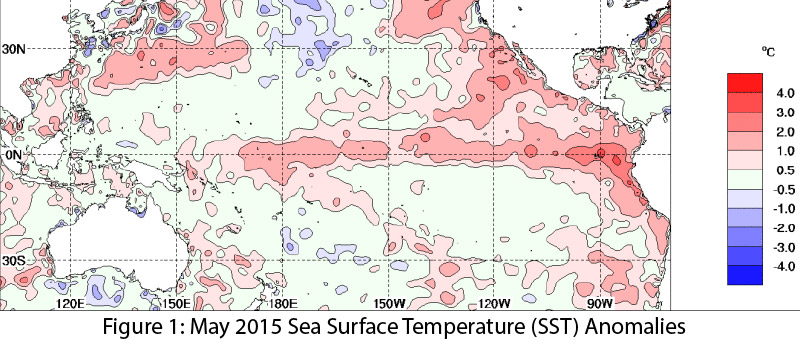
El Niño continued for a third straight month, with no signs of weakening or dissipating. Forecasts keyed in on persistent sea surface temperature (SST) anomalies (Figs. 1–2), along with weakening trade winds, ongoing convective activity, and El Niño-related ocean-atmosphere coupling. If these conditions continue, we are likely to see the effects of a moderate El Niño event–or stronger if conditions continue to strengthen. Spring forecasts have a higher degree of uncertainty, owing to the so-called spring predictability barrier, a likely source of vacillations in recent forecasts. (read more)
 Image Source - Australian Bureau of Meteorology
Winter/Spring Recap 2014-2015
Originally published in the May 2015 CLIMAS SW Climate Outlook
It may not be news to anyone who follows weather forecasting and climate outlooks, but winter 2014–2015 did not play out as expected. Last year, long-term seasonal forecasts keyed in on conditions favorable to the development of an El Niño event and suggested we were more likely to see above-average precipitation in our winter months. This was welcome news to a region that has been affected by a long-term and persistent drought, but rather than sustained above-average precipitation, we saw highly variable precipitation between October 2014 and April 2015 (Fig. 1) and cumulative water year-to-date precipitation that is below average across much of Arizona and parts of New Mexico (Fig. 2 on page 2). Temperature was much less variable, with record or near-record warm average temperatures across most of the western U.S. (Fig. 4 on page 2). So what does this mean for some key areas of concern in the Southwest? (read more)
Southwest Climate Outlook May 2015
Originally published in the May 2015 SW Climate Outlook
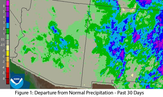
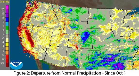
Precipitation: In the past 30 days, most of New Mexico and much of central Arizona recorded well above-average precipitation (Fig. 1). Climatologically, this is one of the drier times of year for the Southwest, so any substantive precipitation during this timeframe is generally unexpected but welcome, as it helps tamp down fire risk. Water year observations since October 1 demonstrate the persistent and ongoing drought, with most western states, including Arizona, recording large areas of below-average to well below-average precipitation (Fig. 2). New Mexico and the eastern side of Colorado, Wyoming, and Montana have benefitted from some late season storms, but that rainfall on the other side of the Continental Divide, does not necessarily help the water situation in the Southwest. (read more)
 Image Source - NOAA/NWS - Advanced Hydrologic Prediction Service
 Image Source - NOAA/NWS - Advanced Hydrologic Prediction Service
Monsoon Climate & Wildfire - What Does Winter-Spring Weather Mean for Wildfire Season
Mini-Podcast/News - Southwest Climate Update - May 1, 2015
Podcast introduction: We're introducing a new podcast series (CLIMAS SW Climate Update) that focuses on quick and timely reporting on important climate news and information. We will emphasize stories that relate to the southwest, but we'll also include other climate related news that illustrate the impact of climate on national or global scales. And Mike, Zack, and Ben will still take a deeper look at southwestern climate issues in the monthly CLIMAS Southwest Climate Podcast. This episode, we're focused on record warm temperatures, drought, and snowpack across the west, along with a few stories that illustrate the downstream impact of these conditions.
