The University of Arizona

Monthly Archive | CLIMAS

Monthly Archive

Southwest Climate Outlook - El Niño Tracker - September 2019

Friday, September 20, 2019

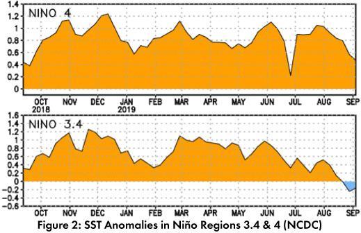
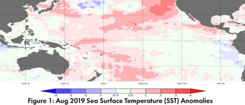
Forecast Roundup: Seasonal outlooks and forecasts based on sea surface temperature (SST) anomalies (Figs. 1-2) and other oceanic and atmospheric indicators all point towards ENSO-neutral conditions lasting through 2019 and into 2020. On Sep 10, the Japanese Meteorological Agency (JMA) highlighted dissipating warmer-than-normal SSTs and maintained their call for a 60-percent chance of ENSO-neutral conditions to continue until winter 2019-2020. On Sep 12, the NOAA Climate Prediction Center (CPC) issued their ENSO diagnostic discussion, which focused on neutral conditions across the oceans and atmosphere. They called for a 75-percent chance of ENSO-neutral conditions persisting through fall 2019. On Sep 12, the International Research Institute (IRI) issued an ENSO Quick Look (Fig. 3), emphasizing neutral conditions in both oceanic and atmospheric ENSO indicators. Their models see ENSO-neutral as the most likely outcome, but with “slightly higher chances for El Niño than La Niña”. On Sep 17, the Australian Bureau of Meteorology maintained their ENSO Outlook at ‘inactive’ with most oceanic and atmospheric conditions in the range of neutral. The North American Multi-Model Ensemble (NMME) is within the range of ENSO-neutral and is forecast to remain neutral through 2019, with more variability and uncertainty into 2020 (Fig. 4). (Read More)

Southwest Climate Outlook September 2019 - Climate Summary

Friday, September 20, 2019

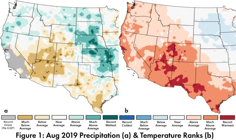
Monthly Precipitation and Temperature: August precipitation was much below average in most of Arizona, while most of New Mexico ranged from above average to much below average, and both states saw small pockets of record driest conditions (Fig. 1a). August temperatures were much above average to record warmest in Arizona and New Mexico (Fig. 1b). The daily average temperature anomalies for Aug 1 – Sep 17 highlight the fluctuations at select stations around the region (Fig. 2) (Read More).


Monsoon Recap - September 2019

Monday, September 16, 2019

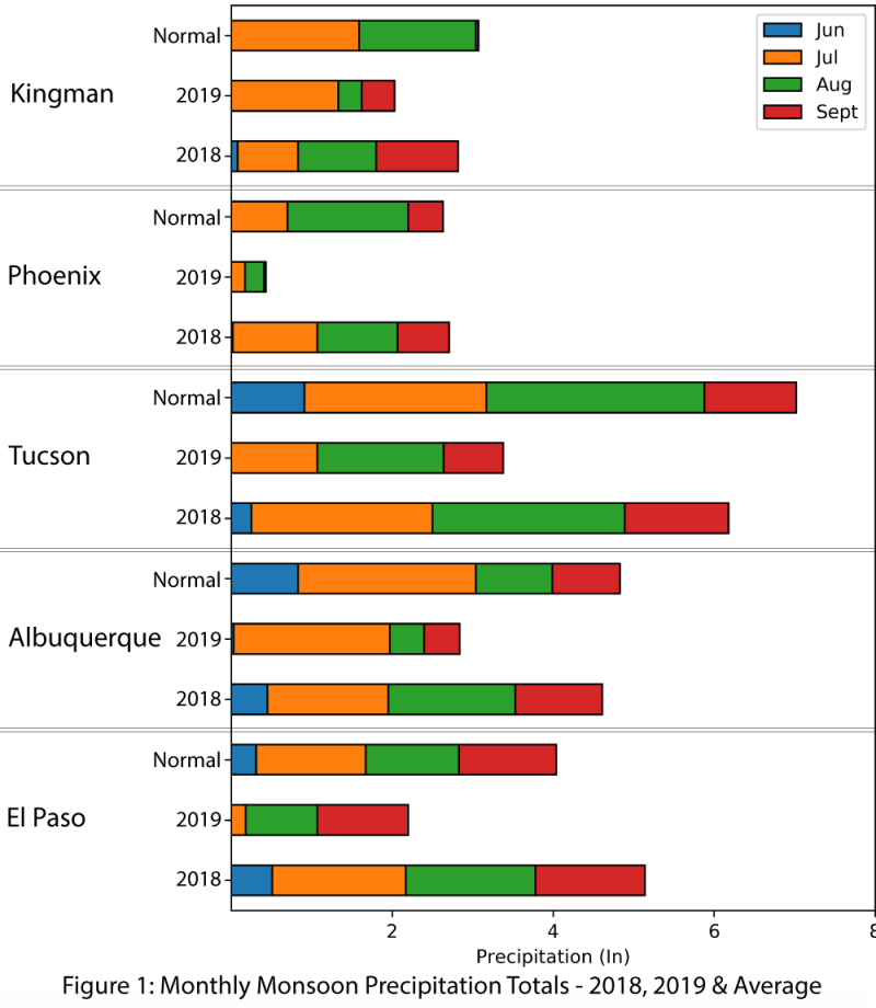
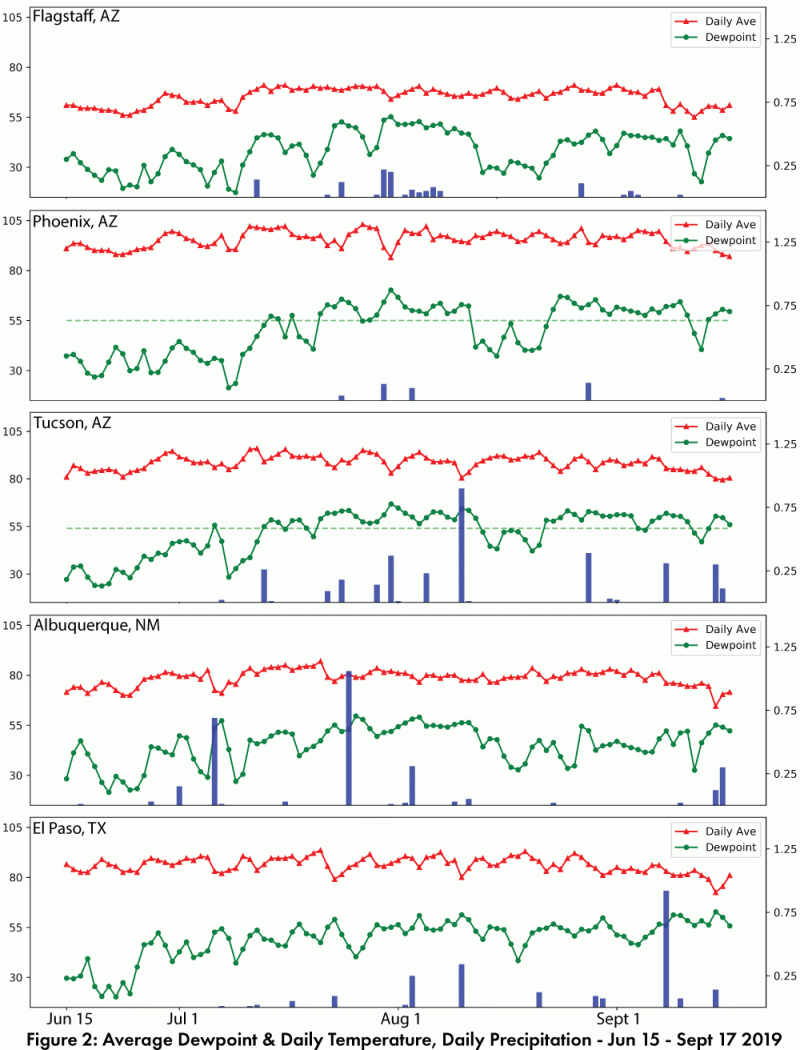
Single weather stations are an imperfect measure of monsoon spatial variability, but they do provide an opportunity to track long term averages compared to the current year. Figure 1 compares 2019 precipitation to date with 2018 and climatology. This reveals 2019 is lagging behind average in terms of precipitation and is also a significant departure from 2018’s widespread activity that continued into September. Daily average and dewpoint temperatures, along with daily and cumulative precipitation illustrate that while increased dewpoint temperatures do not guarantee monsoon precipitation, it is rare to see monsoon precipitation in the absence of these elevated dewpoint temperatures (Fig. 2). (Read More)