Southwest Climate Outlook August 2019 - Climate Summary
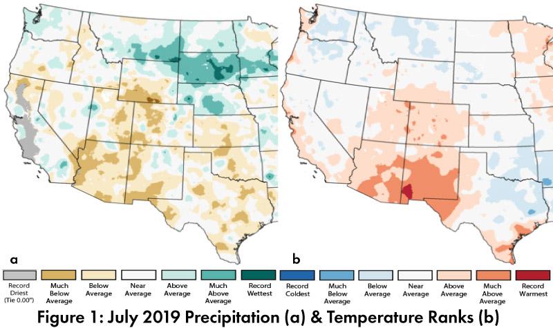
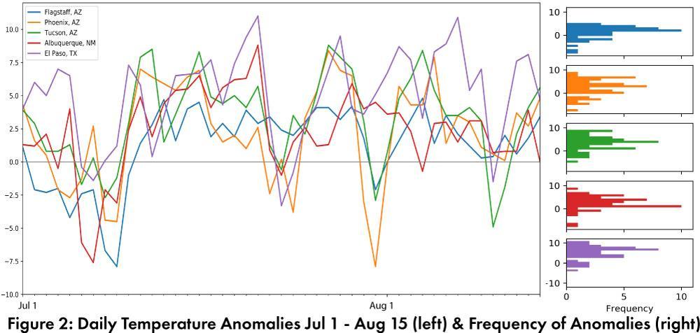
Monthly Precipitation and Temperature: July precipitation was mostly below average to much below average in Arizona, while New Mexico ranged from above average to much below average (Fig. 1a). July temperatures were mostly above average to much above average in Arizona and New Mexico, with a small pocket of record warmest in southwestern New Mexico (Fig. 1b). The daily average temperature anomalies for Jul 1 – Aug 15 (Fig. 2) highlight the fluctuations at select stations around the region.
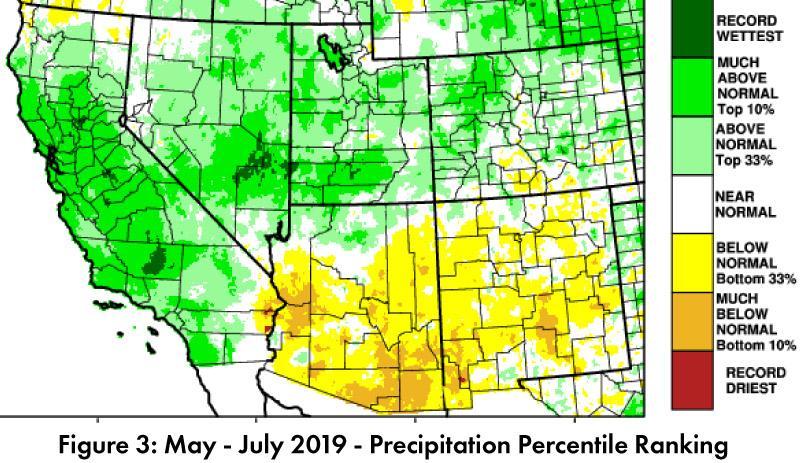
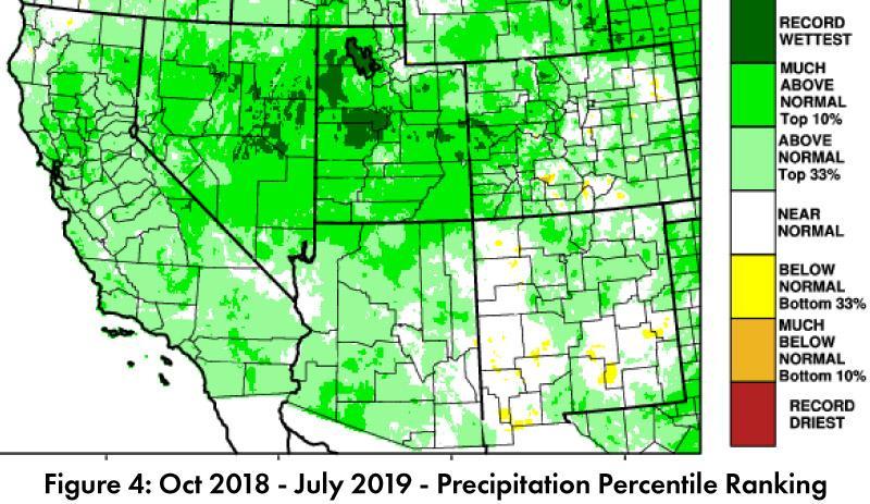
Seasonal Precipitation and Temperature: Total precipitation for the last three months (May-July) was below normal or much below normal for most of Arizona and New Mexico (Fig. 3), and limited early season tropical storms and a late monsoon onset are part of this story. Water year precipitation to date reveals the extent to which much of the Southwest has recorded above average precipitation over the last year, with parts of New Mexico and Colorado as the only areas without normal to above normal precipitation (Fig. 4).
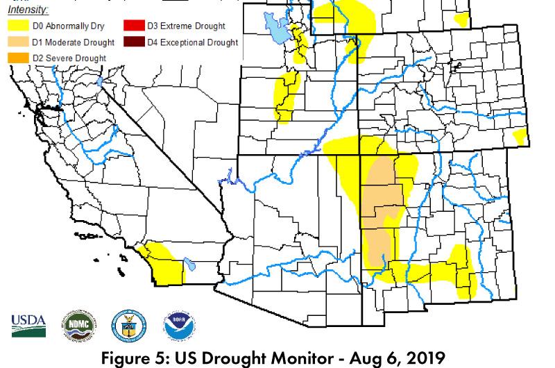
Drought: Despite the recent below average precipitation, the impact of longer-term above average precipitation in much of the Southwest is reflected in the Aug 6 U.S. Drought Monitor (USDM), which continues to document relatively low levels of drought designation in Arizona and New Mexico (Fig. 5). The past three months of mostly below average precipitation, and the late onset of the monsoon, however, will lead drought experts to closely monitor these conditions.
Water Supply: Most of the reservoirs in the region are at or above the values recorded at this time last year, but most also remain below their long-term average (see Arizona and New Mexico reservoir storage). This illustrates improvements in drought conditions over the past year, but also highlights accumulated water resource deficits linked to multiple years of drought.
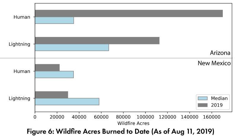
Wildfire, Health, and Safety: Despite a late and somewhat sporadic onset of monsoon activity, the resulting precipitation and increased humidity has helped tamp down elevated wildfire risk in much of the Southwest. The National Interagency Fire Center outlooks for August and September each call for average fire risk across the region. In terms of wildfire acres burned, lightning and human caused fires are above median in Arizona, and below median in New Mexico (Fig. 6).
El Niño Tracker: Despite hints (or hope) that this El Niño event might last into early 2020, conditions have returned to ENSO-neutral and are likely to remain neutral through the rest of 2019 and into 2020 (see ENSO-tracker for details).
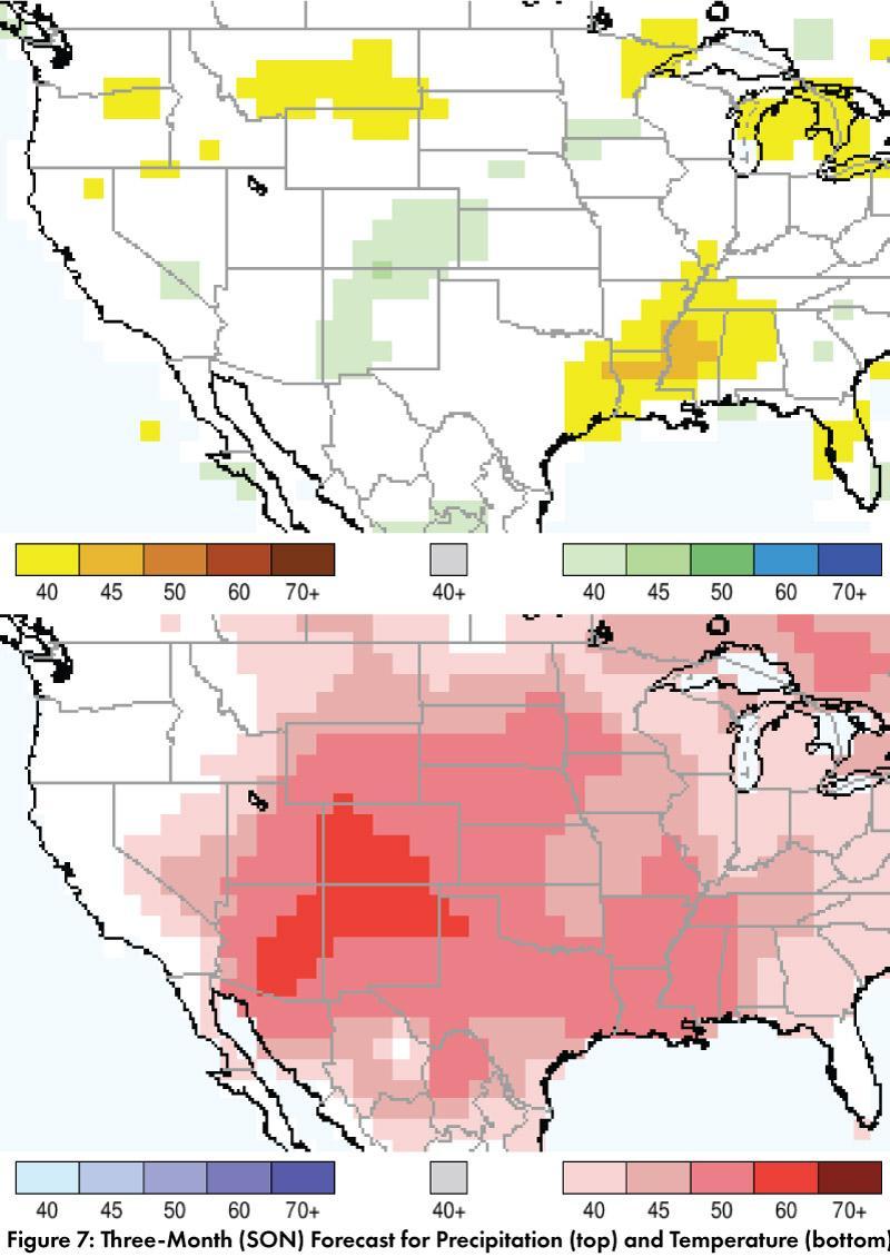
Precipitation and Temperature Forecast: The three-month outlook for September through November calls for increased chances of above-normal precipitation in parts of New Mexico, with equal chances of above- or below-normal precipitation in the rest of Arizona, New Mexico, west Texas, and northern Mexico (Fig. 7, top). The three-month temperature outlook calls for increased chances of above-normal temperatures across most of the U.S. Southwest and northern Mexico (Fig. 7, bottom).
Online Resources
- Figures 1 - National Centers for Environmental Information - ncei.noaa.gov
- Figure 2, 6 - Climate Assessment for the Southwest - climas.arizona.edu
- Figure 3, 4 - Western Regional Climate Center - wrcc.dri.edu
- Figure 5 - U.S. Drought Monitor - droughtmonitor.unl.edu
- Figure 7 - International Research Institute for Climate and Society - iri.columbia.edu

