The University of Arizona

edriesen's blog | CLIMAS


edriesen's blog

Southwest Climate Outlook - El Niño Tracker - June 2019

Thursday, June 27, 2019

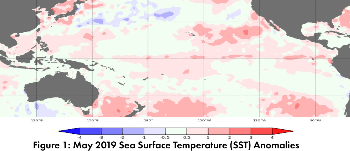
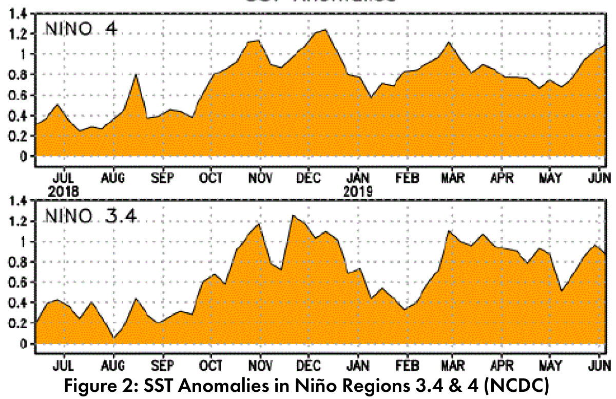
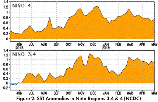
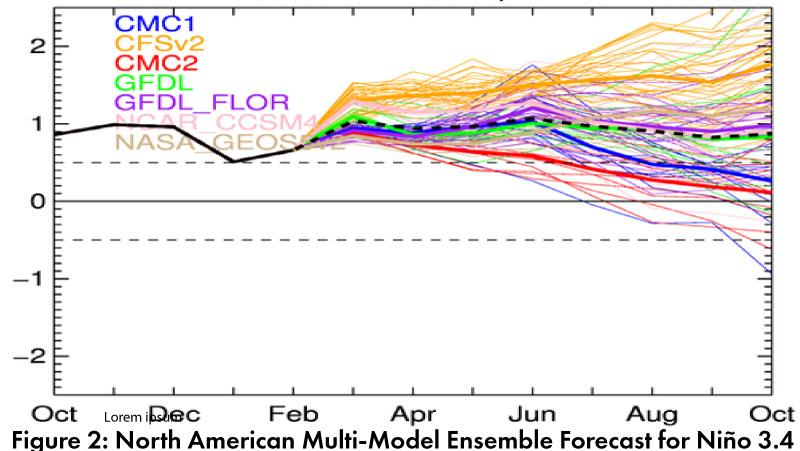
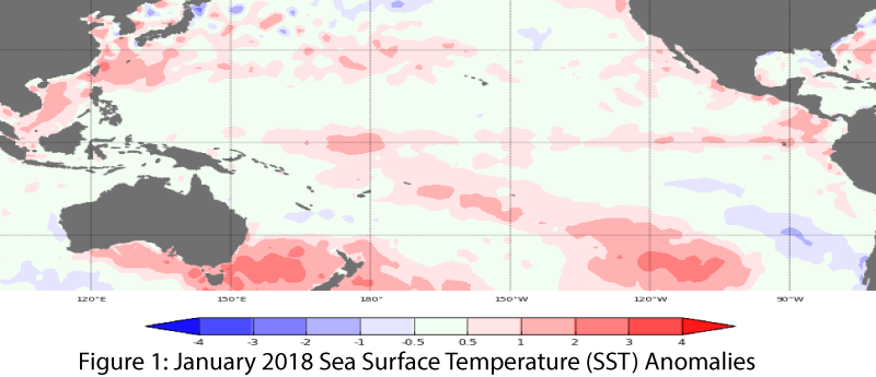
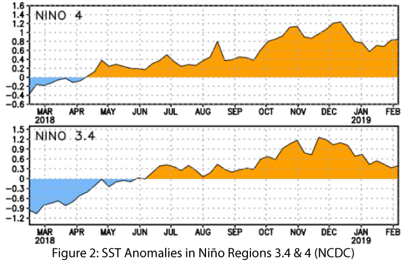
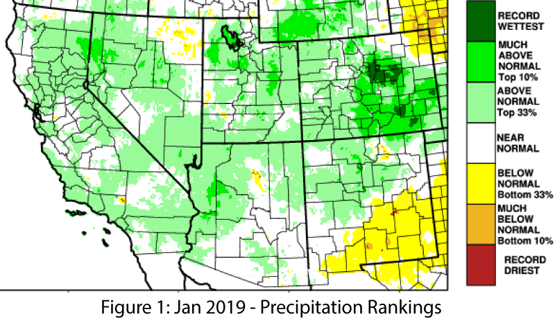
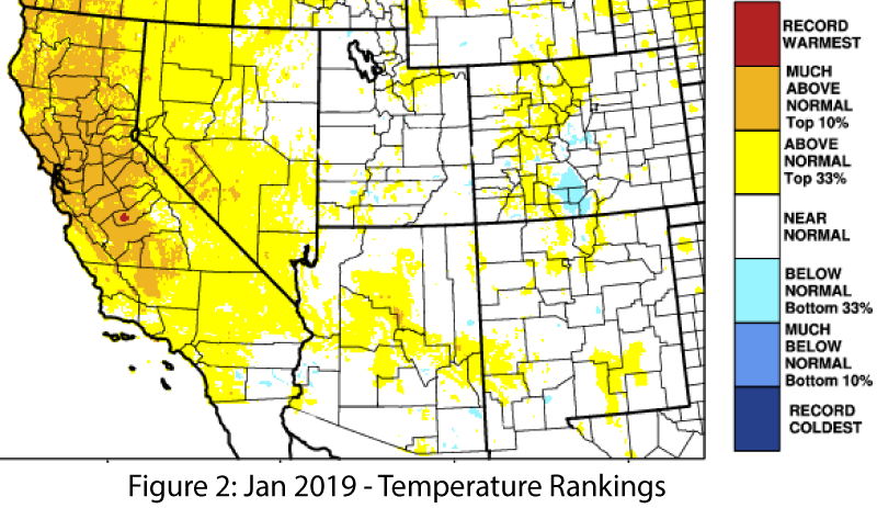
Forecast Roundup: Seasonal outlooks are based on the persistence of sea surface temperature (SST) anomalies consistent with a weak El Niño event (Figs. 1-2), along with the presence of other atmospheric and oceanic indicators (convective anomalies, sub-surface temperatures). On June 10, the Japanese Meteorological Agency (JMA) noted persistent SST anomalies along with atmospheric and sub-surface indicators of El Niño, and called for a 70-percent chance of these conditions continuing into summer, and a 60-percent chance to last into fall. On June 11, the Australian Bureau of Meteorology maintained their ENSO Outlook at watch status, calling for a 50-percent chance of an El Niño event in 2019. (read more)


Southwest Climate Outlook June 2019 - Climate Summary

Thursday, June 27, 2019

May Precipitation and Temperature: May precipitation was mostly above average to record wettest in Arizona, and New Mexico ranged from below average to much above average but most of the state was average or above-average (Fig. 1a). May temperatures were below average or much below average across most of the Southwest (Fig. 1b). (read more)

Southwest Climate Outlook - El Niño Tracker - May 2019

Sunday, May 26, 2019

Seasonal outlooks highlight persistent sea surface temperature (SST) anomalies consistent with a weak El Niño event (Figs. 1-2), while other atmospheric and oceanic indicators such as convective anomalies and sub-surface temperatures are less definitive. The so-called ‘spring predictability barrier’ further limits certainty. Forecast discussions focus on how long the event will last and the potential for a second year of El Niño. (read more)


Southwest Climate Outlook May 2019 - Climate Summary

Sunday, May 26, 2019

April Precipitation and Temperature: April precipitation was average to much above-average in most of New Mexico, while Arizona ranged from below-average to above-average (Fig. 1a). April temperatures were almost entirely above-average to much above-average across the Southwest (Fig. 1b), while temperatures so far in May have been mostly below-average. (read more)

Southwest Climate Outlook - El Niño Tracker - April 2019

Thursday, April 25, 2019

El Niño Tracker: Seasonal outlooks and forecasts emphasize clear atmospheric and oceanic conditions that are consistent with a weak El Niño event, and the discussion has shifted to how long the event will last. On Apr. 10, the Japanese Meteorological Agency (JMA) highlighted that El Niño conditions had persisted in March, and with an 80-percent chance of these conditions lasting until summer. On Apr. 11, the NOAA Climate Prediction Center (CPC) maintained their El Niño advisory, identifying both oceanic and atmospheric conditions consistent with a weak El Niño event. (read more)


Southwest Climate Outlook April 2019 - Climate Summary

Thursday, April 25, 2019

March Precipitation and Temperature: March precipitation was average to above-average across most of Arizona, New Mexico and west Texas, while the upper basin of the Colorado River was much above-average (Fig. 1a). March temperatures were average to above-average in Arizona and New Mexico, despite most of the United States being average to below-average (Fig. 1b).read more


Southwest Climate Outlook - El Niño Tracker - March 2019

Wednesday, March 20, 2019

El Niño Tracker: Seasonal outlooks have mostly converged on forecasts that emphasize atmospheric and oceanic conditions consistent with a weak El Niño event. This is expected to last through spring, with a chance for a longer event if these conditions persist through summer and into fall. On Mar. 11, the Japanese Meteorological Agency (JMA) maintained their assertion of the presence of El Niño conditions in the equatorial Pacific and called for a 70-percent chance of these conditions lasting until summer 2019. On Mar. 14, the NOAA Climate Prediction Center (CPC) maintained their El Niño advisory, given the convergence of oceanic and atmospheric conditions, as well as warm subsurface waters on the way, and their outlook jumped to an 80-percent chance of an El Niño lasting through spring (and 60-percent through summer). On Mar. 19, the International Research Institute (IRI) issued an ENSO Quick Look (Fig. 1). (read more)


Southwest Climate Outlook March 2019 - Climate Summary

Wednesday, March 20, 2019

February Precipitation and Temperature: February precipitation was above-average across most of Arizona and northwestern New Mexico (and much of the western United States), but quickly transitioned to below-average in southern and eastern New Mexico, a pattern that extended into western Texas (Fig. 1a). February temperatures were below-average in most of Arizona and northwestern New Mexico, and average to above-average in central and eastern New Mexico (Fig. 1b). (read more)

Southwest Climate Outlook - El Niño Tracker - February 2019

Sunday, February 17, 2019

After months of El Niño on the horizon (but each month not appearing to get any closer), forecasters have identi ed the convergence of atmospheric and oceanic conditions that indicate the presence of a weak El Niño event. This is expected to last through spring, although there is not complete agreement across the international agencies. On Feb. 12, the Japanese Meteorological Agency (JMA) maintained their assertion of the presence of El Niño conditions in the equatorial Pacific and called for a 70-percent chance of these conditions lasting until summer 2019. (read more)

Southwest Climate Outlook February 2019 - Climate Summary

Wednesday, February 6, 2019

January Precipitation and Temperature: January was wetter-than-normal across much of northern Arizona and New Mexico, near-normal in southern Arizona, and below-normal across most of southern New Mexico (Fig. 1). January temperatures were normal to above-normal (Fig. 2). Winter storms brought wet and cool conditions to the region in February – including some heavy snow forecast later in the week of Feb 18. These storms feel like a departure, but may simply be closer to normal winter conditions in the Southwest, with expectations having shifted after persistent warm and dry winter conditions over the past few years or decades. (read more)


Pages

Subscribe to RSS - edriesen's blog