Southwest Climate Outlook - El Niño Tracker - August 2019
El Niño Tracker
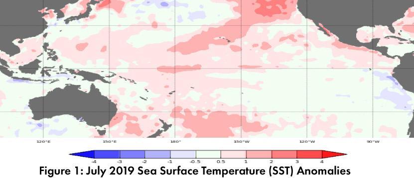
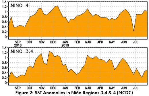
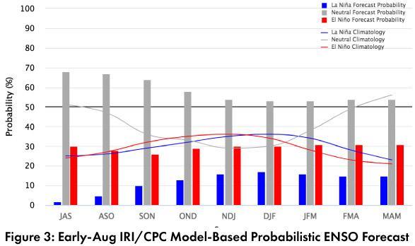
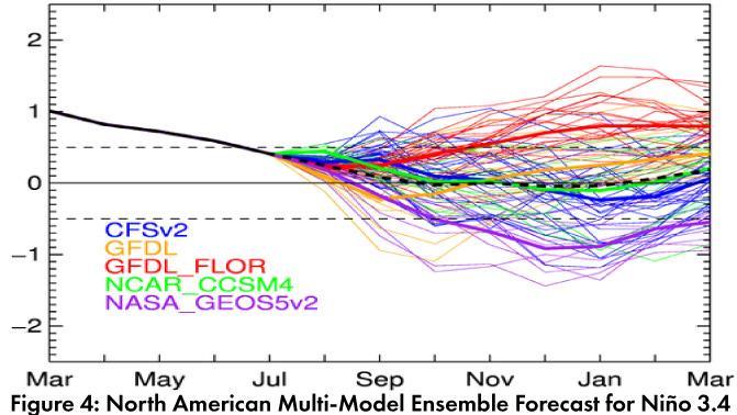
Forecast Roundup: Seasonal outlooks and forecasts based on sea surface temperature (SST) anomalies (Figs. 1-2) and other oceanic and atmospheric indicators have all identified the end of this El Niño event. On Aug 6, the Australian Bureau of Meteorology maintained their ENSO Outlook at ‘inactive’, stating that “all climate models indicate the tropical Pacific is likely to remain ENSO-neutral for the rest of 2019”. On Aug 8, the NOAA Climate Prediction Center (CPC) issued their final El Niño advisory, which reflects the end of oceanic and atmospheric conditions indicative of El Niño. They called for a 50-55% chance of ENSO-neutral conditions persisting through winter 2019-2020. On Aug 8, the International Research Institute (IRI) issued an ENSO Quick Look (Fig. 3), confirming the end of El Niño as SSTs returned to normal in July. Their models see ENSO-neutral as the most likely outcome, but with “higher chances for El Niño than La Niña”. On Aug 9, the Japanese Meteorological Agency (JMA) highlighted a return to normal SSTs and other atmospheric indicators and maintained their call for a 60-percent chance of ENSO-neutral conditions to continue until winter 2019. The North American Multi-Model Ensemble (NMME) is within the range of ENSO-neutral and is forecast to remain there through 2019 and into 2020 (Fig. 4).
Summary: As predicted in more recent model runs, oceanic and atmospheric conditions have returned to within the range of normal, and this El Niño event is officially over. This is in spite of earlier outlooks that were rather bullish on El Niño lasting into fall and winter of this year, and it will be interesting to track how forecasters make sense of this relatively quick swing in forecasts in the next month or so. In terms of the Southwest, seasonal outlooks had been calling for above average precipitation in late summer and early fall, likely tied to the increased chance of enhanced tropical storm activity in the eastern pacific associated with El Niño. With a return to ENSO-neutral, the role that El Niño might play in enhancing those pacific tropical storms is much less relevant, and this has been a quiet tropical storm season so far (at least in terms of southwestern impacts). This does not mean there is an increased chance of drier than normal conditions, but it does mean that the enhanced tropical storm activity associated with El Niño is no longer in play.
Online Resources
- Figure 1 - Australian Bureau of Meteorology - bom.gov.au/climate/enso
- Figure 2 - NOAA - Climate Prediction Center - cpc.ncep.noaa.gov
- Figure 3 - International Research Institute for Climate and Society - iri.columbia.edu
- Figure 4 - NOAA - Climate Prediction Center - cpc.ncep.noaa.gov


