The University of Arizona

Monthly Archive | CLIMAS

Monthly Archive

Extreme Heat in the Southwest - June 19, 2017
Monday, June 19, 2017

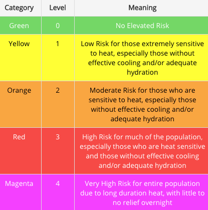
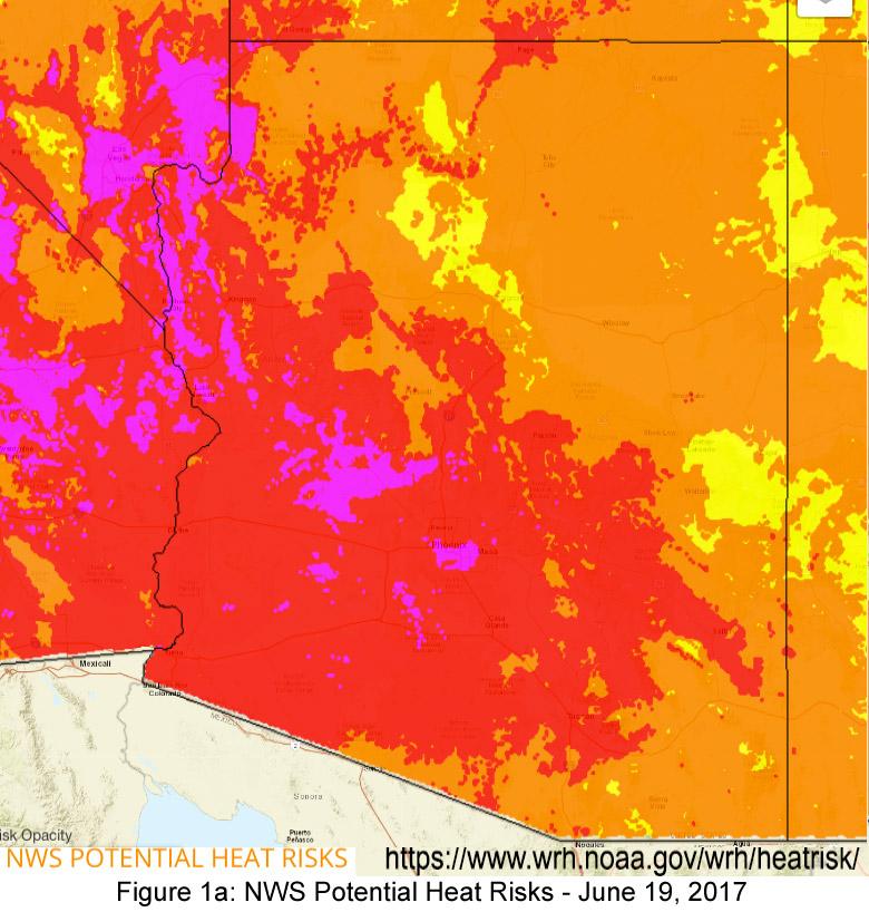
At the time of publication (Jun 15, 2017), an extreme heatwave is forecast to hit the Southwest beginning later this week and extending into next week the week of June 19, peaking on/around June 19-20, 2017. Tucson is currently forecast to reach 114, while Phoenix may see temperatures reach 120 – both of which are approaching the record high temperatures for Tucson and Phoenix, respectively. Southwestern summers have a well-earned reputation for extreme temperatures, and compared to most of the country, even a ‘normal’ summer day is often much warmer than record high temperatures in more temperate locales. The Phoenix NWS office is piloting an experimental heat extremes tracker/map that highlights the risk potential associated with direct exposure and more sustained heat events. (Figs. 1a-ab). (read more)

CLIMAS SW Climate Outlook - ENSO Tracker June 2017

Friday, June 16, 2017

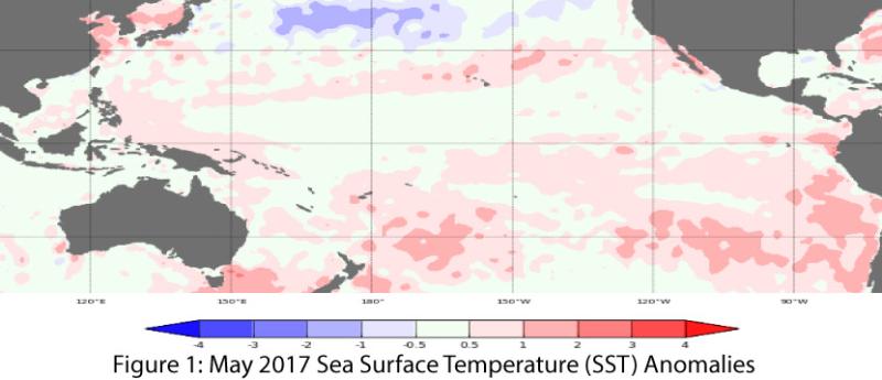
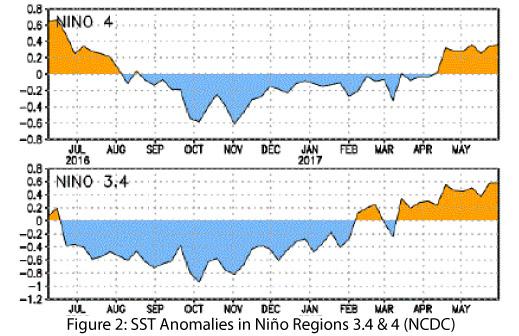
Oceanic and atmospheric indicators of the El Niño-Southern Oscillation (ENSO) are still within the range of neutral (Figs. 1-2), although sea-surface temperatures more consistently hint at borderline El Niño conditions compared to atmospheric indicators. Outlooks and forecasts generally agree that ENSO-neutral conditions will persist through the summer and is the most likely scenario for the rest of 2017. A lingering possibility remains of an El Nino event developing later this fall, but forecasts since last month have shifted further from that likelihood. (read more)


CLIMAS SW Monsoon Outlook - June 2017

Friday, June 16, 2017

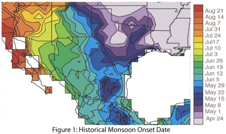
In 2008, the National Weather Service changed the definition of the start of the Southwest monsoon from a variable date based on locally measured conditions to a fixed date of June 15. Prior to 2008, the start date reflected the seasonal progression of the monsoon (Fig. 1). This is based on larger seasonal atmospheric patterns and the establishment of the ‘monsoon ridge’ in the Southwest (Figs. 3a-b, also see sidebar for link to NWS pages).

In Southern Arizona, the start date was based on the average daily dewpoint temperature. Phoenix and Tucson NWS offices used the criteria of three consecutive days of daily average dewpoint temperature above a threshold (55 degrees in Phoenix, 54 degrees in Tucson) to define the start date of the monsoon. As shown in Figure 2, the dewpoint temperature criterion produced start dates ranging from mid-June to late July over the period of record (1949-2016). The average daily dewpoint temperature is still a useful tool to track the onset and progression of conditions that favor monsoon events, and the National Weather Service includes a dewpoint tracker in their suite of monsoon tools. (read more)

Southwest Climate Outlook June 2017 - Climate Summary

Thursday, June 15, 2017

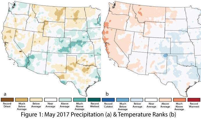
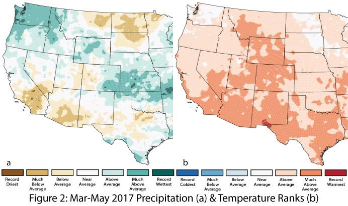
Precipitation & Temperature: May precipitation was variable across the Southwest, ranging from average to much-above average in Arizona and below to above average in New Mexico (Fig. 1a). Similarly, May temperatures were average to above average across Arizona and ranged from below to above average in New Mexico (Fig. 1b). Taking a longer view, spring (March-May) precipitation was mostly below average in Arizona, while New Mexico ranged from below average in the southwestern region to above average in the northeast (Fig. 2a). Spring temperatures were much-above average across most of the Southwest (Fig. 2b). So far in June, temperatures have ranged from 0 to 8 degrees above normal across much of Arizona and New Mexico, with extreme heat forecast for the week of June 19. June precipitation has been sparse in most of Arizona, with infrequent storm activity mostly in southern and eastern New Mexico. (read more)