The University of Arizona

ben's blog | CLIMAS


ben's blog

Mar 2017 SWCO - ENSO Tracker

Friday, March 17, 2017

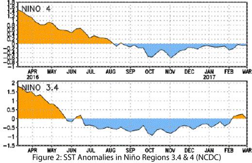
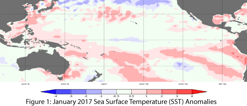
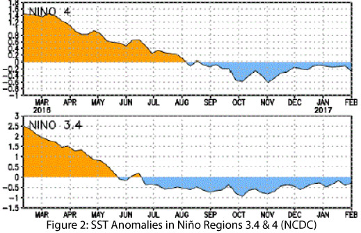
Oceanic and atmospheric indicators of the El Niño-Southern Oscillation (ENSO) are currently neutral (Figs. 1-2), and most forecast agencies predict they will remain so through spring 2017. These agencies also forecast that El Niño conditions could return in mid-to-late 2017, but given the uncertainty of ENSO forecasts associated with the “spring predictability barrier,” we can get only a general sense now of the range of outcomes likely later this year (i.e. La Niña is basically off the table). More detailed information about the timing or intensity of a possible El Niño will start to become available in late spring or early summer. (read more)

CLIMAS Southwest Climate Outlook - Mar 2017 Climate Summary

Thursday, March 16, 2017

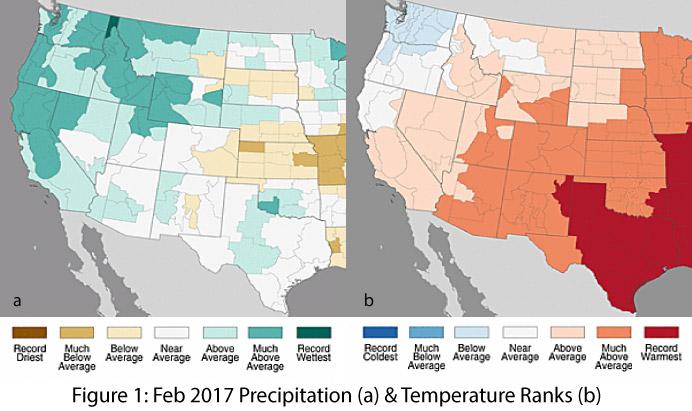
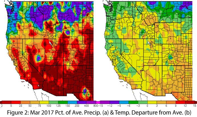
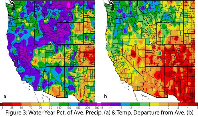
Precipitation & Temperature: February precipitation totals were average to above average in Arizona and ranged from below to above average in New Mexico (Fig. 1a). February temperatures were much-above average across most of region, including record warmest temperatures in eastern New Mexico (Fig. 1b). March precipitation to date has been dry across the Southwest, reversing the wet trends of early winter (Fig. 2a). March temperatures have also been above average across the Southwest (Fig. 2b), including a run of near-record temperatures at the time of this writing. Water-year precipitation and temperature are both above average across much of the Southwest (Fig. 3). (read more)

SWCO ENSO Tracker - Feb 2017

Friday, February 17, 2017

Originally published in the Feb 2017 CLIMAS Southwest Climate Outlook


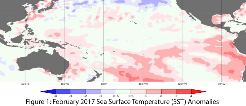
The La Niña event of 2016-2017 is officially over, with oceanic and atmospheric indicators of the El Niño-Southern Oscillation (ENSO) having returned to neutral conditions (Figs. 1-2). Neutral conditions are expected to remain in place for the next few months, but the usual difficulty in accurate forecasting that occurs in the spring means the current ENSO forecast includes a wide range of timing and uncertain outcomes. Most forecast agencies are predicting that ENSO-neutral conditions will remain in place through at least spring 2017, with a possible return of El Niño conditions sometime in mid-to-late 2017. (read more)

Southwest Climate Outlook February 2017 - Climate Summary

Thursday, February 16, 2017

Originally published in the Feb 2017 CLIMAS Southwest Climate Outlook


Precipitation & Temperature: January precipitation totals were above average in Arizona, and in New Mexico they ranged from much-above average to record wettest (Fig. 1a). January temperatures were average to above average in Arizona, and above average in New Mexico (Fig. 1b). February precipitation to date has been variable across the West. In Arizona, it has been mostly below average; in New Mexico, a few large pockets have received impressive precipitation; and widespread activity has occurred across Northern California and the upper Great Basin (Fig. 2a). February temperatures have been well-above average across the southern two-thirds of the western U.S., with particularly warm temperatures in parts of Utah and Colorado (Fig. 2b). Water-year precipitation is average to above average across most of the Southwest except for southern Arizona and much of southeastern New Mexico (Fig. 3). (read more)

La Niña Tracker - Jan 2017

Friday, January 20, 2017

Oceanic and atmospheric indicators of the El Niño-Southern Oscillation (ENSO) continue to indicate weak La Niña conditions that are in rapid decline. Most forecast agencies identified a likely end to La Niña conditions (and by extension, this La Niña event) by February. This is not surprising given many of the oceanic and atmospheric indicators of La Niña have been weak to borderline neutral for much of the last few months (Figs. 1-2). (read more)

Southwest Climate Outlook January 2017 - Climate Summary

Thursday, January 19, 2017

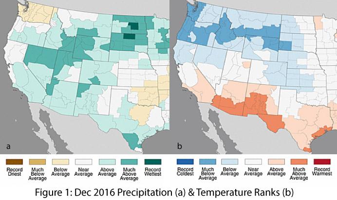
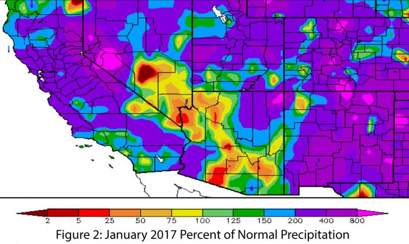
Precipitation & Temperature: December precipitation totals for the past 30 days were above average to much above average in Arizona’s climate divisions and were mostly above average in New Mexico’s climate divisions (Fig. 1a). December temperatures were much above average across most of southern Arizona and southwestern New Mexico, with mostly above-average temperatures across the remainder of the two states (Fig. 1b). A number of storm systems in so far 2017 have brought well above-average moisture to the region, although portions of Arizona have missed out on this precipitation (Fig. 2). January temperatures have been warmer than average across the Southwest and colder than average across the Northwest. (read more)

Clean Energy Policy and Indigenous Territorial Rights: Notes from my Collaborative Research in Southern Chile

Tuesday, December 20, 2016

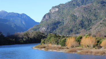
Windy, sunny days, cold nights and mornings, and occasional rains mark the beginning of spring in southern Chile. White flowered plum trees dot the landscape. Hummingbirds and bees buzz between flower treats. The campo is bustling. Long days are dedicated to turning the fields, planting, weeding, and preparing animals for new pastures. Farmers are planting earlier in hopes that plants will be hardier. Not enough rain fell this year, and farmers are worried about summer water supplies. Concerns about drought’s effects are overshadowed by the looming questions regarding ongoing small hydropower development on the many rivers and streams of the sacred Puelwillimapu territory of the Mapuche-Huilliche people.

Life between Hope and Despair: Climate Change Impacts in Coastal Bangladesh

Monday, December 19, 2016

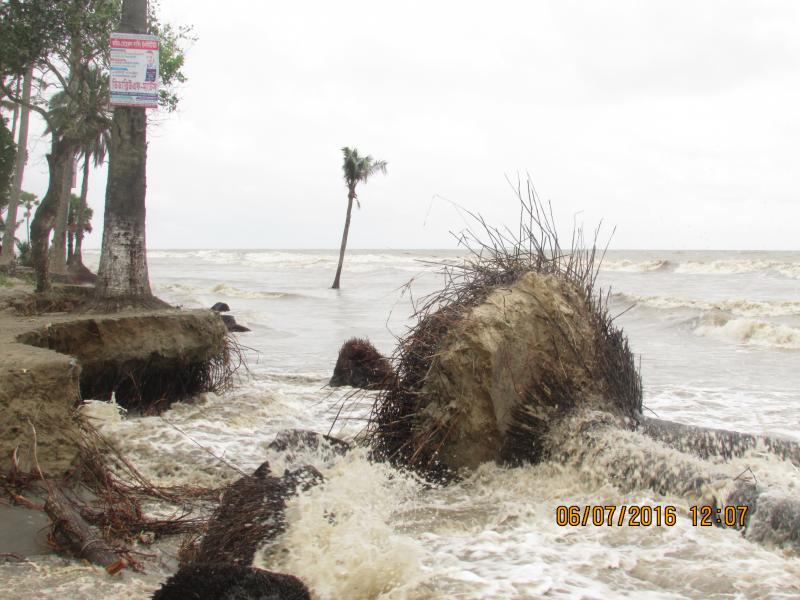
Traveling across southwest coastal Bangladesh is not easy. With limited transport infrastructure and facilities, people might end up spending an entire day or night just to travel small distances. In the last week of May (2016), when I arrived coastal city Kuakata in Patuakhali district, literally I spent the whole night to travel ca. 150 miles from Khulna (a regional big city, which is 170 miles southwest of the capital Dhaka). It was a rainy early morning in Kuakata. However, it didn’t took much time to realize local vulnerability to climate impacts. I went to the Kuakata sea beach, and saw how local people are living with the risks of rising tides and coastal erosion. I clearly understood why for local people climate change is not an issue of scientific or political discourse; for them, it is the reality.

read more

Dec 2016 La Niña Tracker

Friday, December 16, 2016

From the December issue of the CLIMAS Southwest Climate Outlook

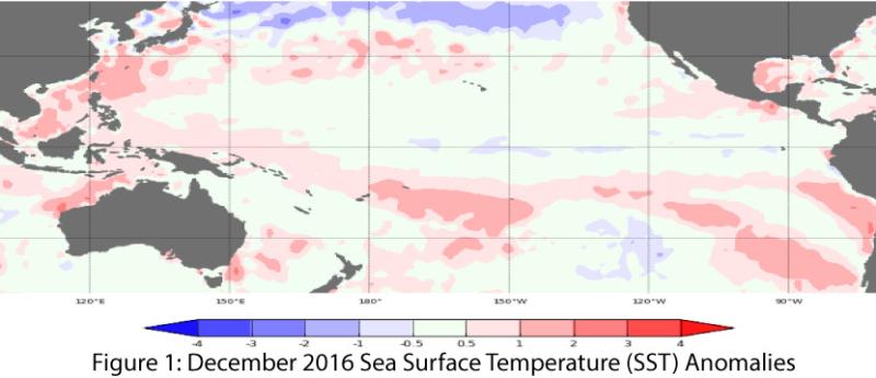
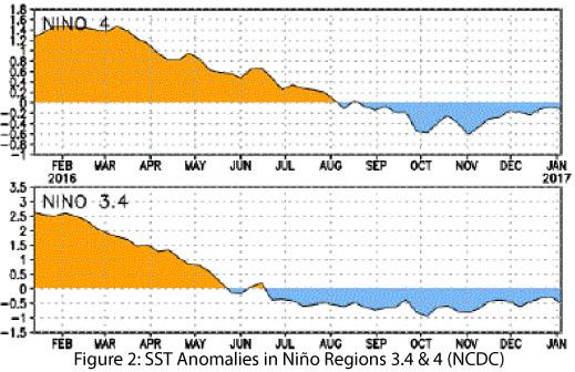
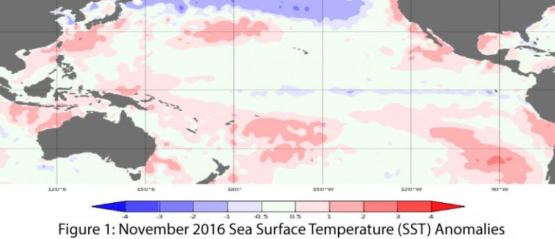
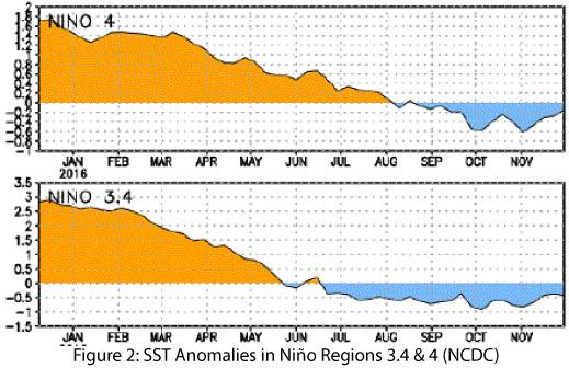
Oceanic and atmospheric indicators of the El Niño-Southern Oscillation (ENSO) continue to indicate a weak La Niña event that is likely to last through mid-winter at least and perhaps into early spring (Figs. 1-2). The borderline weak status of the event, along with some discrepancy between the forecast agencies discussed here, means a more rapid transition to ENSO-neutral conditions cannot be ruled out. As with last month, there is some hedging in the forecasts and outlooks that likely stems from ongoing uncertainty as to whether the event can maintain even weak La Niña strength through winter 2017 (December–February). Fluctuations in forecasts and models are due to the limited coordination between oceanic and atmospheric conditions described in previous outlooks, “masking…by intra-seasonal activity” (as described by the CPC on Dec 8), and the difficulty in categorizing borderline conditions into a binary choice between weak La Niña and ENSO-neutral.

read more

Dec 2016 CLIMAS Southwest Climate Outlook - Climate Summary

Thursday, December 15, 2016

From the December issue of the CLIMAS Southwest Climate Outlook

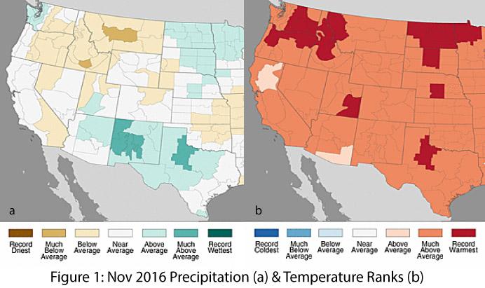
Precipitation & Temperature: November precipitation totals were average to above average in Arizona’s climate divisions, and above average to much above average in New Mexico’s climate divisions (Fig. 1a). November temperatures were much above average across most of Arizona and all of New Mexico (Fig. 1b). This continued a trend of warm temperatures this fall, with parts of Arizona and New Mexico recording record warm temperatures in October and November (Fig. 2). Very little precipitation has fallen in December. This is not unexpected, as the Southwest generally receives limited precipitation between the end of the monsoon and early fall tropical storm activity and the uptick in precipitation in mid-winter into spring (when much of the cool season precipitation falls in the region). Temperatures in December have been mostly above normal in Arizona and western New Mexico, with cooler-than-normal temperatures in eastern New Mexico (Fig. 3). The upcoming polar vortex in the upper midwestern and eastern U.S., in addition to atmospheric river activity off the U.S. Pacific Coast, should shift this pattern in the latter half of December. 

read more

Pages

Subscribe to RSS - ben's blog