Southwest Climate Outlook January 2016
In this Issue:
In this Issue:
The Climate & Society Graduate Fellows Program supports University of Arizona graduate students whose work connects climate research and decision making. The program is made possible by support from the Climate Assessment for the Southwest (CLIMAS), the International Research Applications Program (IRAP), and the UA Office for Research and Discovery. Fellows receive $5,000 and guidance from members of the CLIMAS research team for one year. The program’s main objective is to train a group of students to cross the traditional boundaries of academic research into use-inspired science and applied research. While CLIMAS research generally occurs in the Southwest U.S., the Fellows program allows students to work anywhere in the world.
Fellows’ projects may follow two tracks. Students who want to conduct collaborative research may use their funding for use-inspired projects. Students who have conducted climate research and want to communicate their findings to audiences outside of academia may use their funding for outreach. Fellows may also use their funding for a combination of the two tracks.
The Climate & Society Graduate Fellows Program helps students address the world’s climate-related problems by funding projects that engage people outside of the university.
The 2016 Climate Assessment for the Southwest (CLIMAS) Climate & Society Graduate Fellows are:
|
|
Schuyler ChewCollaborative Outreach and Climate Adaptation Planning with the Pyramid Lake Paiute Tribe |
|
Stina JanssenSolar Sovereignty: use-inspired collaborative research for affordable off-grid solar on the Navajo Nation |
|
Sarah Kelly-RichardsOutreach for Small Hydropower Governance in Chile |
|
January has kicked off with a bang, and the much anticipated super-mega-Godzilla El Nino is upon us. El Niño conditions have been in place for months (Figure 1: Oceanic Niño Index), but has this El Niño event been impacting the weather of the Southwest in ways that are expected? Sort of, but not exactly. (read more)

Gregg Garfin discusses SW Climate, monsoon precipitation, and El Niño with KTEP.
Visit the KTEP page for streaming audio and more information
What do wildflowers, hantavirus, downhill skiing, locusts, and floods all have in common? The answer is El Niño in the Southwest. These subjects represent a small sample of media stories written during the last 33 years that connect regional impacts to the El Niño phase of the El Niño-Southern Oscillation (ENSO) and help illustrate an evolution in our understanding of the significance of El Niño to the region. (read more)
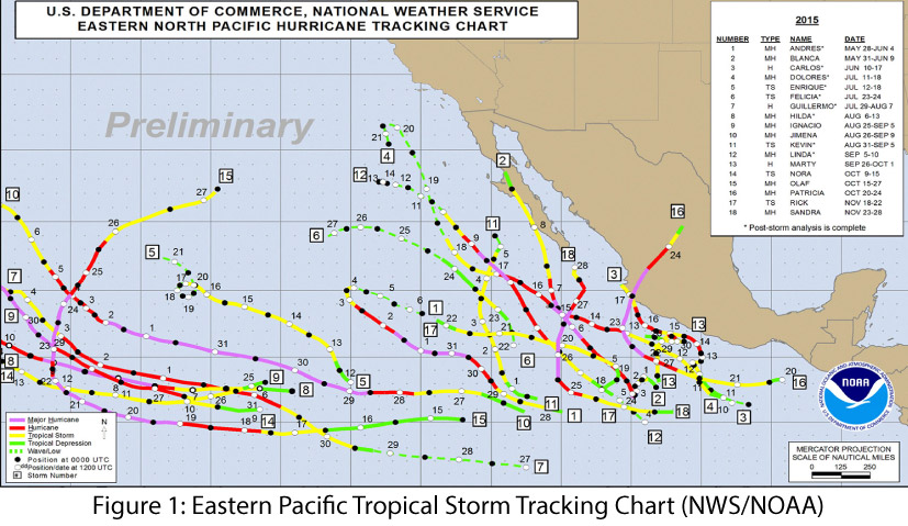
The 2015 eastern Pacific tropical storm season was one of the most active seasons on record, with 18 named storms and 13 hurricanes, nine of which reached “major” hurricane status (category 3 or greater). We also saw the strongest hurricane on record, Patricia, in the eastern Pacific in late October, and the latest-forming major hurricane on record, Sandra, in late November (see NOAA’s National Hurricane Center for more details). This meets or exceeds the high end of the NOAA-Climate Prediction Center (CPC) seasonal forecast (from May 27), which predicted 15 to 22 named storms, seven to 12 hurricanes, and five to eight major hurricanes. The eastern Pacific hurricane forecast was tied to the ongoing El Niño forecast discussion, as conditions linked to El Niño (e.g., decreased wind shear in the tropical Pacific) also favored increased hurricane frequency and intensity in the Pacific region. (read more)
El Niño conditions continued for a 10th straight month, and models continue to forecast a strong El Niño event that will last through spring 2016 and remain strong through the early part of the year. Forecasts focused on the persistence of sea surface temperature (SST) anomalies (Figs. 1–2) and weakened trade winds, enhanced convective activity in the central and eastern Pacific, and El Niño-related ocean-atmosphere coupling. Notably, the SST values in the Niño 3.4 region were at or above the record values in November. Climate scientists have been quick to point out that numerous factors contribute to the overall strength of El Niño, but we are certainly seeing one of the strongest events on record. (read more)
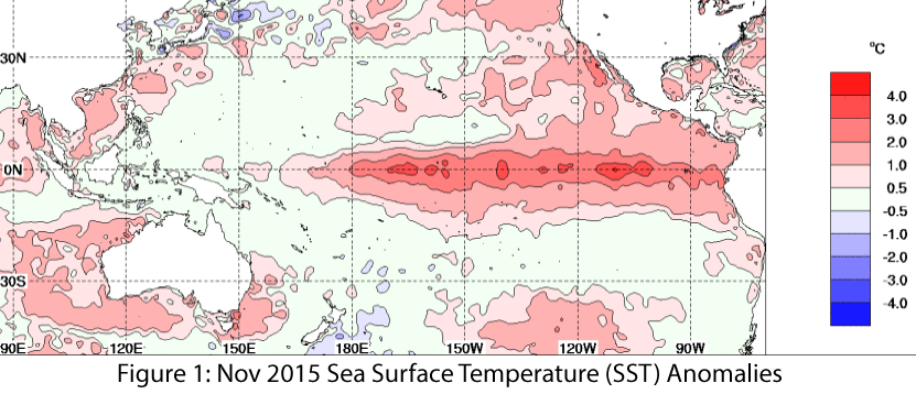 Image Source - Australian Bureau of Meteorology
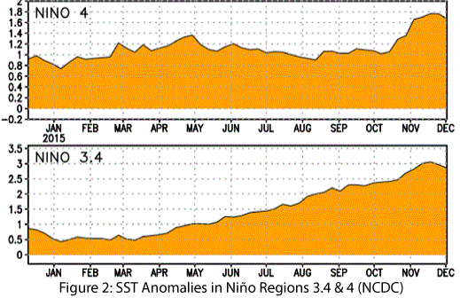 Image Source - NOAA/NWS - Climate Prediction Center
In this Issue:
 Image Source - Advanced Hydrologic Prediction Service
 Image Source - NOAA - National Centers for Environmental Information
We are usually able to enjoy the patio by October, but the mosquitoes were still biting. What does the science tell us about El Niño and mosquito-borne disease? Short answer: it’s complicated. (read more)
Originally published as part of the Nov 2015 CLIMAS Southwest Climate Outlook
El Niño conditions continued for a ninth straight month, and models continue to forecast a strong El Niño event that likely will last through spring 2016 and remain strong through the early part of the year. Forecasts focused on the persistence of sea-surface temperature (SST) anomalies (Figs.1–2) and weakened trade winds, enhanced convective activity in the central and eastern Pacific, and El Niño-related ocean-atmosphere coupling. (read more)
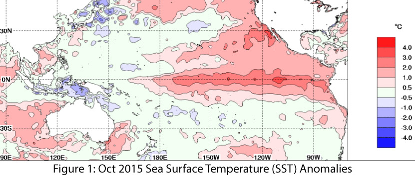 Image Source - Australian Bureau of Meteorology