The University of Arizona

ben's blog | CLIMAS


ben's blog

El Niño Tracker - May 2016

Friday, May 20, 2016

El Niño conditions continued for a 15th straight month, but the peak intensity has long since passed and the event is moving toward ENSO-neutral status. Forecast discussions focused on the decline of atmospheric and oceanic anomalies that characterize an El Niño event, many of which are trending towards—or have nearly reached—ENSO-neutral status. (read more)

Southwest Climate Outlook May 2016 - Climate Summary

Thursday, May 19, 2016

Originally published in the May 2016 CLIMAS Southwest Climate Outlook


Precipitation & Temperature: Across most of the Southwest, April 2016 precipitation totals were above average (Fig 1a) and temperatures were average to above average (Fig 1b). Over the past 30 days, the Southwest experienced a minor cooling trend, with much of the region recording below-average temperatures (Fig. 2a) and a mix of above- and below-average precipitation (Fig. 2b). Increased rainfall and below-average temperatures are a welcome, albeit temporary, break from the typical warming and drying trend observed in late spring and early summer.

El Niño Tracker - March 2016 - Time Winding Down for El Niño in the Southwest

Friday, March 18, 2016

Originally published in the Mar 2016 CLIMAS Southwest Climate Outlook

El Niño conditions continued for a 13th straight month, but the peak of this event has passed. Monitoring and forecast discussions emphasize strong positive sea surface temperature (SST) anomalies (Figs. 1–2) and enhanced convective activity in the central and eastern Pacific. These positive temperature anomalies are waning, and trade wind activity is increasing, indications that this El Niño event is on the decline. Most forecasts emphasize this event will continue through spring or early summer before returning to ENSO-neutral status. (read more)

Southwest Climate Outlook March 2016 - Last Gasp for El NIño?

Thursday, March 17, 2016

In the Mar 2016 issue of the CLIMAS Southwest Climate Outlook (SWCO)

Southwest Climate Summary & Recap (this post - read more)

  • Precipitation & Temperature
  • Drought, Snowpack & Water Supply
  • El Niño Tracker
  • Environmental Health and Safety (including wildfire)
  • Precipitation & Temperature Forecast Summaries

Also in this issue: 

Image Source - Advanced Hydrologic Prediction Service

Image Source - NOAA National Centers for Environmental Information

2015-2016 El Niño Tracker - Feb 2016

Monday, February 22, 2016

El Niño conditions continued for a 12th straight month, but we have passed the peak intensity of one of the strongest El Niño events on record. This does not mean that El Niño is over, though. Despite the recent warm and dry conditions in the Southwest, we are likely to see more weather events associated with El Niño conditions through spring 2016. (read more)

Como es que La Oscilación del Sur “El Niño” (ENSO) afecta los patrones del tiempo de la región suroeste?

Monday, February 1, 2016

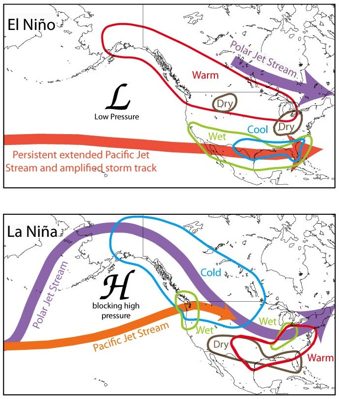
Los eventos El Niño y La Niña se desarrollan generalmente entre Abril y Junio, por lo cual quiere decir que la región suroeste de los Estados Unidos siente los efectos más prominentes de los cambios de la circulación de ENSO durante el invierno y hasta los principios de la primavera. La influencia de ENSO en el tiempo de la región suroeste se correlaciona con su capacidad de cambiar la posición de la corriente en chorro – los vientos en altura que dirigen los sistemas de tormentas y dictan la posición de las áreas de alta y baja presión. Durante los eventos “El Niño,” la corriente en chorro sobre el Océano Pacifico se desarrolla menos ondulada y se separa en una corriente subtropical cerca del ecuador y una corriente polar más débil. (lee mas)

Figura: Los eventos El Niño y La Niña causan que el pasaje de las corrientes en chorro se muevan sobre los Estados Unidos en diferentes lugares, frecuentemente causando inviernos húmedos durante los eventos El Niño e inviernos secos durante los eventos La Niña en el suroeste.  Imagen modificada de la Administración Oceánica y Atmosférica Nacional (NOAA).

Qué es ENSO - La Oscilación del Sur “El Niño”?

Thursday, January 28, 2016

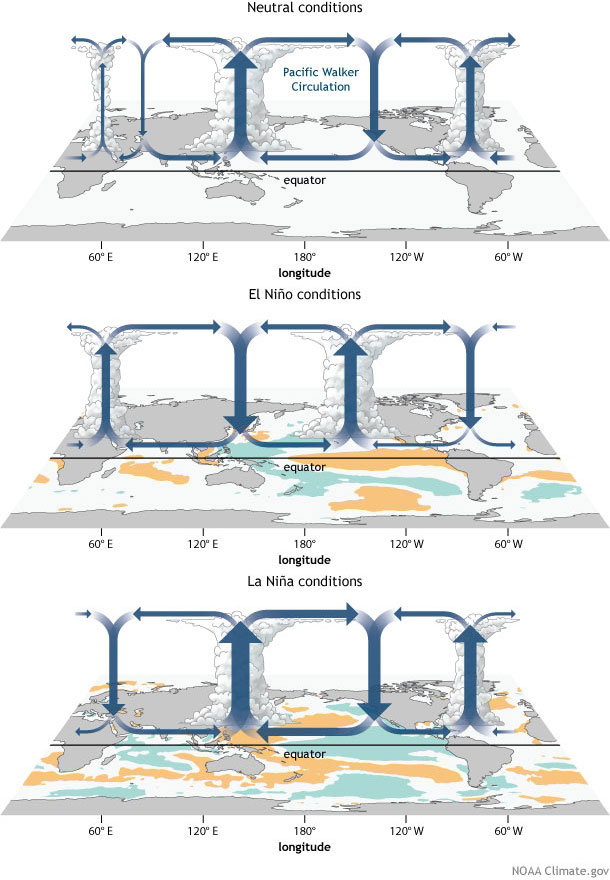
“El Niño” y “La Niña” son parte de la oscilación del sur El Niño, (ENSO por sus siglas). ENSO es una fluctuación natural de las temperaturas superficiales del mar y la presión superficial del aire del Océano Pacifico Tropical entre el este y oeste.  Durante un evento “El Niño,” los vientos alisios del este se debilitan, permitiendo que el agua superficial más cálida  del Océano Pacifico Tropical del oeste corra  hacia el este.  (lee mas).

Figura 1: Eventos El Niño causan que el pasaje invernal de la corriente en chorro  se mueva sobre la región del suroeste, generalmente entregando más lluvia y nieve invernal en la región. Imagen modificada de la Administración Oceánica y Atmosférica Nacional (NOAA).

El Niño Tracker - Jan 2016

Friday, January 22, 2016

El Niño conditions continued for an 11th straight month, putting us squarely in the middle of a strong El Niño event that will be among one of the strongest events on record. Forecasts focused on the persistence of sea surface temperature (SST) anomalies (Figs. 1–2) and weakened trade winds, enhanced convective activity in the central and eastern Pacific, and El Niño-related ocean-atmosphere coupling. Models continue to forecast a strong El Niño event that will last through spring 2016, but we are starting to see signs of decline in the overall strength of the event. (read more)

Pages

Subscribe to RSS - ben's blog