Southwest Climate Outlook February 2017 - Climate Summary
Originally published in the Feb 2017 CLIMAS Southwest Climate Outlook
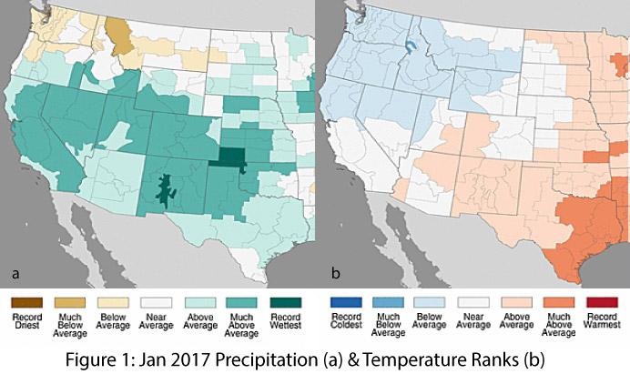
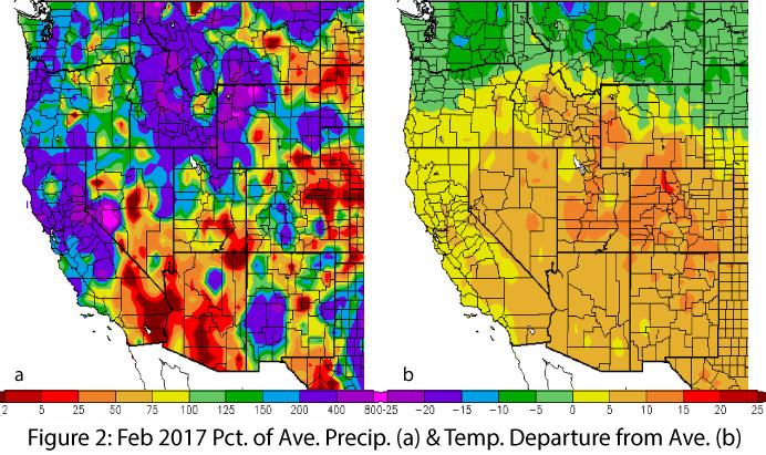
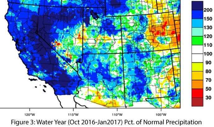
Precipitation & Temperature: January precipitation totals were above average in Arizona, and in New Mexico they ranged from much-above average to record wettest (Fig. 1a). January temperatures were average to above average in Arizona, and above average in New Mexico (Fig. 1b). February precipitation to date has been variable across the West. In Arizona, it has been mostly below average; in New Mexico, a few large pockets have received impressive precipitation; and widespread activity has occurred across Northern California and the upper Great Basin (Fig. 2a). February temperatures have been well-above average across the southern two-thirds of the western U.S., with particularly warm temperatures in parts of Utah and Colorado (Fig. 2b). Water-year precipitation is average to above average across most of the Southwest except for southern Arizona and much of southeastern New Mexico (Fig. 3).
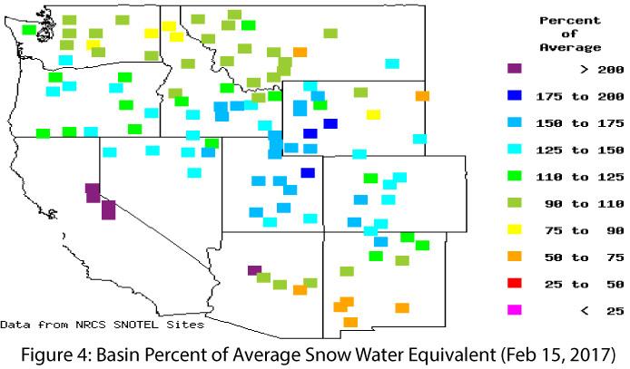
Snowpack & Water Supply: Over the past 30 days, numerous storm events brought substantial precipitation to much of the West, particularly northern California and the upper Colorado River Basin, contributing to large increases in snowpack across much of the West. This welcome precipitation was accompanied by increased temperatures, leading to serious reservoir management issues in California (i.e. the Oroville dam spillway concerns and necessitating small mid-winter releases in the Verde River system in Arizona. Current snow water equivalent (SWE) is well-above average across much of the Intermountain West, but the extent to which above-average temperatures will affect water storage dynamics across the West (e.g., rain vs. snow, storage, evaporation, runoff, infiltration, etc.) remains to be seen. SWE is average to above average across the higher elevation areas of central and northern Arizona and New Mexico, but below average in southern portions of both states (Fig. 4). Spring and summer streamflow forecasts for Arizona and New Mexico reflect the abundant snowpack, ranging from 90 to 180 percent of average.
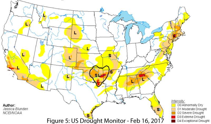
Drought: Long-term drought conditions remain across much of the Southwest (Fig. 5), although the recent run of moisture in the West has improved drought in regions of northern California and parts of the Intermountain West. According to the February 16 U.S. Drought Monitor, much of Arizona is designated as abnormally dry (D0) or experiencing moderate drought (D1). The far southwestern corner of the state is still designated as experiencing severe drought (D2), reflecting the persistent multi-year drought conditions extending from central and Southern California. Recent storm events have improved drought conditions in parts of New Mexico, but the Drought Monitor still identifies a small pocket in eastern New Mexico as abnormally dry (D0) or in moderate drought (D1).
El Niño Southern Oscillation: The La Niña event of 2016-2017 is officially over, but as a weak event that quickly faded to neutral conditions, it may be difficult to distinguish La Niña’s influence from the already dry signal of southwestern winters. Neutral conditions are expected to remain for at least the next few months, with a longer-term view suggesting a possible return of El Niño conditions.
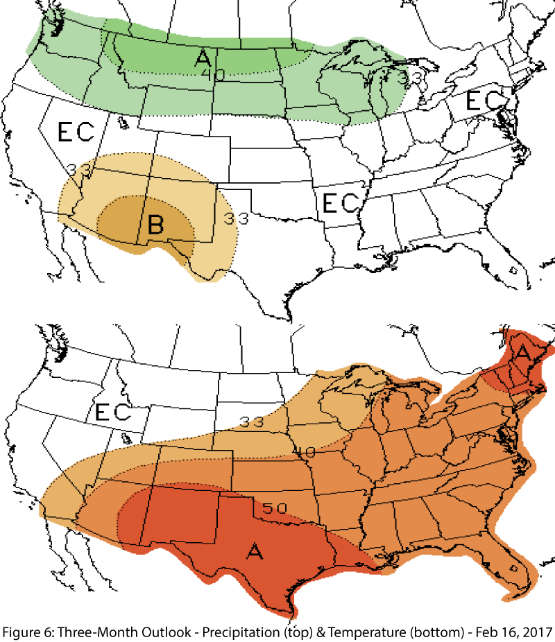
Precipitation & Temperature Forecasts: The February 16 NOAA Climate Prediction Center’s outlook for March calls for increased chances of below-average precipitation and above-average temperatures across the region. The three-month outlook for March through May also calls for increased chances of below-average precipitation (Fig. 6, top) and above-average temperatures (Fig. 6, bottom).

