The University of Arizona

Blog | CLIMAS

Blog

Heidi Brown (CLIMAS PI) & Joceline Lega win DARPA Chikungunya Virus Forecasting Competition

Wednesday, July 8, 2015

Full version of this story originally appeared in the UANews on July 1, 2015


A UA team (including our very own Heidi Brown) has won an international competition for its work developing methods for advanced forecasting of infectious disease. (read more)

More info on the DARPA Forecasting Chikungunya Challenge

June 2015 SW Climate Podcast - Tropical Storms, Monsoon, Wildfire & El Niño

Wednesday, July 1, 2015

In the June 2015 edition of the CLIMAS SW Climate Podcast, Mike Crimmins and Zack Guido recap the month of June, including the quick transition from cool and wet to hot and muggy conditions.  The discuss the impact of tropical storms on the region, the early start to this season, and what this may or may not mean in terms of relationship to monsoon patterns.  They turn to El Niño, and the impact the El Niño signal may be having on the region, both looking back at the past few months, but in particular looking forward at what this could mean for the southwest in terms of precipitation patterns over the next 12 months. (read more)

El Niño Tracker - June 2015

Friday, June 19, 2015

Originally Published in the June 2015 CLIMAS SW Climate Outlook (SWCO)


El Niño conditions continued for a fourth straight month with no signs of weakening or disorganizing. Forecasts focused on the persistence of sea-surface temperature (SST) anomalies (Figs.1 - 2) along with weakening trade winds, ongoing convective activity, and El Niño-related ocean-atmosphere coupling. Despite the high degree of uncertainty associated with forecasting El Niño this time of year (the so-called spring predictability barrier), the most recent outlooks from various sources offer a consistent cluster of forecasts calling for a clear El Niño signal that is maintained or even strengthening. (read more)


Image Source - Australian Bureau of Meteorology

Southwest Climate Outlook June 2015

Thursday, June 18, 2015

Originally Published in the June 2015 CLIMAS SW Climate Outlook (SWCO)


Precipitation: In the past 30 days, most of New Mexico and much of northern Arizona recorded well-above-average precipitation (Fig. 1).  Climatologically, we are in one of the drier times of year for the Southwest, so this precipitation and humidity (mostly tied to early season Pacific tropical storm activity) helped tamp down fire risk. This respite was short-term however, as water-year observations since October 1 reflect persistent and ongoing drought conditions, with most of the western U.S. recording well-below-average precipitation (Fig. 2).  Notable exceptions are New Mexico, Colorado, Wyoming, and Montana, but with most recent precipitation falling on the eastern side of the Continental Divide. (read more)


Image Source - NOAA/NWS - Advance Hydrologic Prediction Service

Winter/Spring Recap 2014-2015

Friday, May 22, 2015

Originally published in the May 2015 CLIMAS SW Climate Outlook


It may not be news to anyone who follows weather forecasting and climate outlooks, but winter 2014–2015 did not play out as expected. Last year, long-term seasonal forecasts keyed in on conditions favorable to the development of an El Niño event and suggested we were more likely to see above-average precipitation in our winter months.  This was welcome news to a region that has been affected by a long-term and persistent drought, but rather than sustained above-average precipitation, we saw highly variable precipitation between October 2014 and April 2015 (Fig. 1) and cumulative water year-to-date precipitation that is below average across much of Arizona and parts of New Mexico (Fig. 2 on page 2).  Temperature was much less variable, with record or near-record warm average temperatures across most of the western U.S. (Fig. 4 on page 2). So what does this mean for some key areas of concern in the Southwest?  (read more)

2015 El Niño Tracker

Friday, May 22, 2015

Originally published in the May 2015 CLIMAS SW Climate Outlook


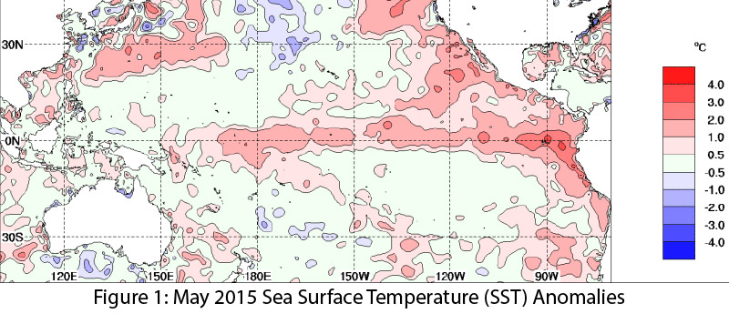
El Niño continued for a third straight month, with no signs of weakening or dissipating. Forecasts keyed in on persistent sea surface temperature (SST) anomalies (Figs. 1–2), along with weakening trade winds, ongoing convective activity, and El Niño-related ocean-atmosphere coupling. If these conditions continue, we are likely to see the effects of a moderate El Niño event–or stronger if conditions continue to strengthen. Spring forecasts have a higher degree of uncertainty, owing to the so-called spring predictability barrier, a likely source of vacillations in recent forecasts. (read more)

Image Source - Australian Bureau of Meteorology

Pages

Subscribe to RSS - blogs