The University of Arizona

Blog | CLIMAS

Blog

Southwest Climate Outlook May 2015

Thursday, May 21, 2015

Originally published in the May 2015 SW Climate Outlook


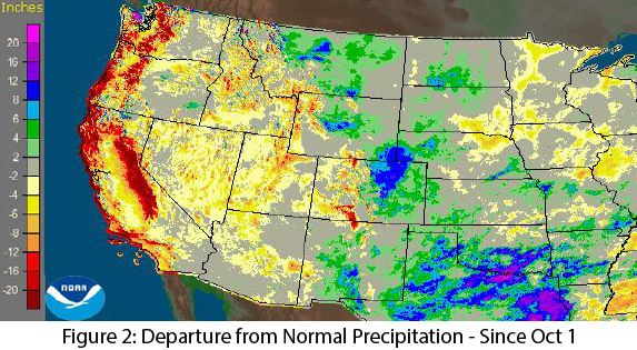
Precipitation: In the past 30 days, most of New Mexico and much of central Arizona recorded well above-average precipitation (Fig. 1). Climatologically, this is one of the drier times of year for the Southwest, so any substantive precipitation during this timeframe is generally unexpected but welcome, as it helps tamp down fire risk. Water year observations since October 1 demonstrate the persistent and ongoing drought, with most western states, including Arizona, recording large areas of below-average to well below-average precipitation (Fig. 2). New Mexico and the eastern side of Colorado, Wyoming, and Montana have benefitted from some late season storms, but that rainfall on the other side of the Continental Divide, does not necessarily help the water situation in the Southwest.  (read more)
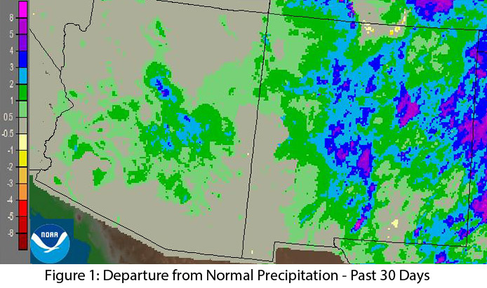
Image Source - NOAA/NWS - Advanced Hydrologic Prediction Service

Image Source - NOAA/NWS - Advanced Hydrologic Prediction Service
Mini-Podcast/News - Southwest Climate Update - May 1, 2015

Monday, May 4, 2015

Podcast introduction: We're introducing a new podcast series (CLIMAS SW Climate Update) that focuses on quick and timely reporting on important climate news and information. We will emphasize stories that relate to the southwest, but we'll also include other climate related news that illustrate the impact of climate on national or global scales.  And Mike, Zack, and Ben will still take a deeper look at southwestern climate issues in the monthly CLIMAS Southwest Climate Podcast. This episode, we're focused on record warm temperatures, drought, and snowpack across the west, along with a few stories that illustrate the downstream impact of these conditions.

Colorado River Delta: Pulse Flow - One Year Later

Wednesday, April 22, 2015

The Colorado River Delta hadn’t seen regularly flowing water in 50 years.  But one year ago the U.S. and Mexico came together to work on a project to move water down the empty riverbed.

On March 23, 2014 these countries released more than 100,000 acre-feet of water into the delta below the Morelos Dam.  This area is along the Colorado River on the U.S.-Mexico border. 

On May 15, 2014, the river finally met the sea. (read more)

El Niño Tracker - April 2015

Friday, April 17, 2015

This was originally published in the April 2015 Southwest Climate Outlook


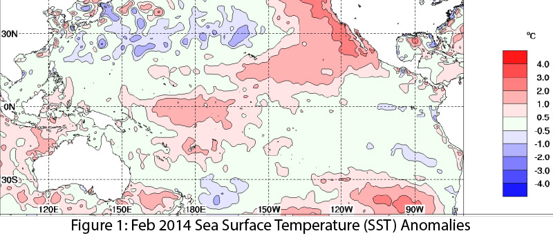
Strong signals in early 2014 stalled, delaying El Niño’s onset until last month, when ocean-atmosphere coupling and an additional Kelvin wave indicated more favorable conditions. Despite this late start, El Niño continued for a second consecutive month. Recent increases in sea surface temperature (SST) anomalies (Fig.1 - 2) and ongoing convective activity associated with El Niño-favorable conditions indicate we might be witnessing a two-year El Niño event. These forecasts rely on projections during a time of increasing uncertainty, and the so-called “spring predictability barrier” continues to make it difficult to anticipate how seasonal changes will help or hinder El Niño. (read more)

Southwest Climate Outlook April 2015 - Climate Summary

Thursday, April 16, 2015

Precipitation: In the past 30 days, most of the southwestern U.S. received below-average precipitation (Fig. 1). The winter wet season is wrapping up, and instead of above-average precipitation (as many of the El Niño influenced seasonal forecasts suggested), water year observations since October 1 show below-average precipitation across much of Arizona and portions of New Mexico. The situation is direr in other western regions, with California, the Pacific Northwest, and the Intermountain West recording significantly below-average winter precipitation (Fig. 2). (read more)

Spring Signals the Start of Wildfire Season for the Southwest

Wednesday, April 15, 2015

A version of this post was also published in the April 2015 Southwest Climate Outlook


Flowers are blooming and trees have sprouted green leaves, signs that spring is in full swing across the Southwest and that, despite a verdant desert, wildfire season is upon us. The outlook for this wildfire season forecasts near-average wildfire activity for much of Arizona and New Mexico.

CLIMAS Colloquium: Connie Woodhouse - Collaborative Research in the Upper Colorado River Basin: User-Driven Research Results and Challenges

Thursday, March 26, 2015

This presentation will focus on ongoing work to better understand the effects of temperature on water supplies in the upper Colorado River basin. Overall, spring and early summer temperatures explain only a small portion of the variance in water year streamflow in the basin. However, in a subset of years (both warm and cool), temperatures appear to have a stronger influence on streamflow than might be anticipated, given the precipitation. The presentation will also touch on the challenges associated with incorporating the input of water resource management partners, a central component of the project design. (read more)

El Niño Tracker - March 2015

Friday, March 20, 2015

Originally published Mar 19, 2015 in the CLIMAS Southwest Climate Outlook

After months of vacillating sea surface temperature (SST) anomalies, limited coordination between oceanic and atmospheric conditions favorable to El Niño formation, and ongoing confusion regarding the strength of the various diagnostic signals, El Niño has “officially” arrived in North America. (read more)

Pages

Subscribe to RSS - blogs