The University of Arizona

Blog | CLIMAS

Blog

CLIMAS SW Monsoon Outlook - June 2017

Friday, June 16, 2017

In 2008, the National Weather Service changed the definition of the start of the Southwest monsoon from a variable date based on locally measured conditions to a fixed date of June 15. Prior to 2008, the start date reflected the seasonal progression of the monsoon (Fig. 1). This is based on larger seasonal atmospheric patterns and the establishment of the ‘monsoon ridge’ in the Southwest (Figs. 3a-b, also see sidebar for link to NWS pages).

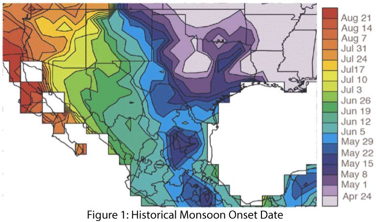
In Southern Arizona, the start date was based on the average daily dewpoint temperature. Phoenix and Tucson NWS offices used the criteria of three consecutive days of daily average dewpoint temperature above a threshold (55 degrees in Phoenix, 54 degrees in Tucson) to define the start date of the monsoon. As shown in Figure 2, the dewpoint temperature criterion produced start dates ranging from mid-June to late July over the period of record (1949-2016). The average daily dewpoint temperature is still a useful tool to track the onset and progression of conditions that favor monsoon events, and the National Weather Service includes a dewpoint tracker in their suite of monsoon tools. (read more)

CLIMAS SW Climate Outlook - ENSO Tracker June 2017

Friday, June 16, 2017

Oceanic and atmospheric indicators of the El Niño-Southern Oscillation (ENSO) are still within the range of neutral (Figs. 1-2), although sea-surface temperatures more consistently hint at borderline El Niño conditions compared to atmospheric indicators. Outlooks and forecasts generally agree that ENSO-neutral conditions will persist through the summer and is the most likely scenario for the rest of 2017. A lingering possibility remains of an El Nino event developing later this fall, but forecasts since last month have shifted further from that likelihood. (read more)


Southwest Climate Outlook June 2017 - Climate Summary

Thursday, June 15, 2017

Precipitation & Temperature: May precipitation was variable across the Southwest, ranging from average to much-above average in Arizona and below to above average in New Mexico (Fig. 1a). Similarly, May temperatures were average to above average across Arizona and ranged from below to above average in New Mexico (Fig. 1b). Taking a longer view, spring (March-May) precipitation was mostly below average in Arizona, while New Mexico ranged from below average in the southwestern region to above average in the northeast (Fig. 2a). Spring temperatures were much-above average across most of the Southwest (Fig. 2b). So far in June, temperatures have ranged from 0 to 8 degrees above normal across much of Arizona and New Mexico, with extreme heat forecast for the week of June 19. June precipitation has been sparse in most of Arizona, with infrequent storm activity mostly in southern and eastern New Mexico. (read more)

CLIMAS SW Climate Outlook - Wildfire Report: Sawmill Fire

Friday, May 19, 2017

The Sawmill fire (Fig. 1) started, reportedly by recreational shooting, on April 23, 2017 in a grass- and shrub-covered area of low-elevation Arizona state lands approximately 40 miles south of Tucson. The fire spread quickly due to dry and windy conditions that day: the temperature reached 98 degrees, relative humidity ranged between 4 and 18 percent, and sustained winds reached 20 mph with gusts up to 30 mph. High winds, high temperatures, and low relative humidity continued through much of the following week, driving rapid growth of the fire (Fig. 2). (read more)

Southwest Climate Outlook May 2017 - Climate Summary

Thursday, May 18, 2017

Precipitation & Temperature: April precipitation was average to above average in New Mexico, while most of Arizona was below average, including much-below average and record-dry conditions in the southwestern corner of the state (Fig. 1a). April temperatures were above average in nearly all of Arizona and New Mexico, with much-above average temperatures in southern Arizona (Fig. 1b). May has been dry in southern Arizona and New Mexico, while parts of northern Arizona and northern and eastern New Mexico have picked up decent precipitation relative to the normally dry May climate (Fig. 2). May temperatures in Arizona and New Mexico have ranged from 4 degrees below to 4 degrees above normal, while temperatures in higher latitudes and upper elevations (e.g. Upper Colorado River Basin, California Sierras, etc.) have been generally warmer than average, ranging from 0 to 8 degrees above normal. Water year precipitation has been normal to above normal across most of Arizona and New Mexico aside from a small pocket of dry conditions along the Arizona-Mexico border (Fig. 3). (read more)

CLIMAS SW Climate Outlook - ENSO Tracker May 2017

Thursday, May 18, 2017

Oceanic and atmospheric indicators are still within the range of neutral (Figs. 1-2), although sea-surface temperatures have more consistently hinted at El Niño compared to atmospheric indicators. Outlooks and forecasts generally agree that ENSO-neutral conditions are likely to remain through the summer, but by mid-to-late 2017, chances of an El Niño event emerging become approximately equal to the chances of continued ENSO-neutral conditions. (read more)


Climate Services Database Now Available for the Western States

Tuesday, May 9, 2017

More than 130 public sector and nonprofit organizations provide climate services to the eleven western states, yet until now there has been no centralized resource to connect climate information users with the wide array of information and services available.

The  is a searchable directory of climate service providers in the west that makes climate services easier to find. Its powerful search function allows users to customize their search based on the type of service, the geographic area, stakeholders served, and several additional parameters. It’s a match-making app for the climate world.

(read more)

SWCO ENSO Tracker - April 2017

Friday, April 21, 2017

Similar to last month, oceanic and atmospheric indicators of the El Niño-Southern Oscillation (ENSO) are in the range of neutral (Figs. 1-2), and these conditions are forecast to last through the spring and summer. Most forecasts and outlooks indicate that El Niño conditions could return in mid-to-late 2017, but these assessments come with the annual caveat of increased uncertainty associated with the “spring predictability barrier”, during which time the specifics regarding the possibility, timing, and intensity of an El Niño event are elusive. At any rate, the models and forecasts indicate a near-zero probability of La Niña in 2017, leaving forecasters to decide between the probability of neutral or El Niño conditions in later 2017. (read more)

Pages

Subscribe to RSS - blogs