Southwest Climate Outlook June 2017 - Climate Summary
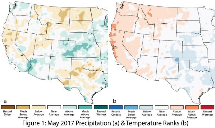
Precipitation & Temperature: May precipitation was variable across the Southwest, ranging from average to much-above average in Arizona and below to above average in New Mexico (Fig. 1a). Similarly, May temperatures were average to above average across Arizona and ranged from below to above average in New Mexico (Fig. 1b). Taking a longer view, spring (March-May) precipitation was mostly below average in Arizona, while New Mexico ranged from below average in the southwestern region to above average in the northeast (Fig. 2a). Spring temperatures were much-above average across most of the Southwest (Fig. 2b). So far in June, temperatures have ranged from 0 to 8 degrees above normal across much of Arizona and New Mexico, with extreme heat forecast for the week of June 19. June precipitation has been sparse in most of Arizona, with infrequent storm activity mostly in southern and eastern New Mexico.
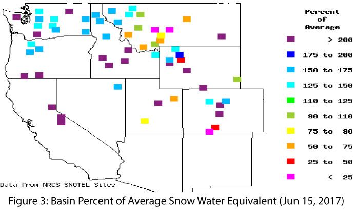
Snowpack, Streamflow & Water Supply: While snow is mostly—if not completely—now gone from the Southwest, some Colorado River Upper Basin snow water equivalent (SWE) values remain well-above average (Fig. 3). Above-average temperatures have amplified melting and runoff, leading to impressive streamflow forecasts across much of the West (see last month’s outlook for details) and, in many cases, higher reservoir volumes compared to one year ago.
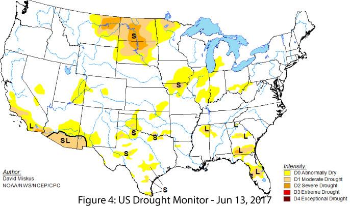
Drought: The transitional period between cool-season precipitation and the monsoon is one of the driest times of year for the Southwest, but prior to this dry period, seasonal temperature and precipitation patterns had been above and below average, respectively, since mid-January. This led to both short- and long-term drought designations in southern Arizona and the southwestern corner of New Mexico (Fig. 4). Monsoon precipitation can be impressive in its intensity, but these events vary considerably in both their spatial extent and their temporal frequency, therefore they typically do not provide as much drought relief as sustained regional cool-season precipitation.
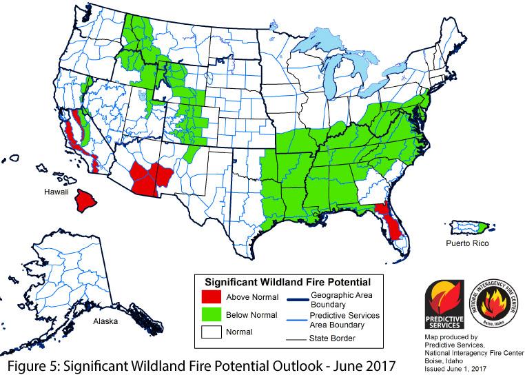
Wildfire, Environmental Health, & Safety: In the late spring and early summer, warming temperatures, low relative humidity, and sustained and gusting winds all contribute to increased risk of wildfire (Fig. 5). Accordingly, the Southwest has seen higher fire activity over the last month. Many of these fires are lightning-caused, as is common when the emergent monsoon brings convective activity, often in the absence of measurable precipitation. As the monsoon settles in, heavy precipitation events and increased relative humidity help suppress existing fires and reduce seasonal wildfire risk. In fact, the midpoint of the wildfire season follows the seasonal progression of the monsoon (see Monsoon Tracker), and a late start to the monsoon can extend the fire season just as an early start can help shorten it.
El Niño Southern Oscillation: Current forecasts suggest an increased likelihood of ENSO-neutral conditions in 2017 (50-55-percent chance), with a slightly lower chance of an El Niño event (35-50 percent chance) during the same period (see ENSO Tracker for details).
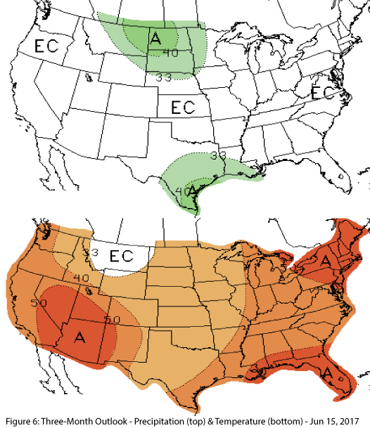
Precipitation & Temperature Forecast: The June 15 NOAA Climate Prediction Center’s outlook for July calls for equal chances of above or below average precipitation in Arizona and New Mexico, and increased chances of above average temperatures across the Southwest. The three-month outlook for July through September calls for equal chances of above or below average precipitation in Arizona and New Mexico (Fig. 6, top). Increased chances of above normal temperatures are forecast for the entire southwestern region (Fig. 6, bottom).
Image Credits:
- Figures 1-2 - National Center for Environmental Information - http://www.ncdc.noaa.gov
- Figure 3 - Western Regional Climate Center - http://www.wrcc.dri.edu/
- Figure 4 - U.S. Drought Monitor - http://droughtmonitor.unl.edu/
- Figure 5 - National Interagency Fire Center - www.predictiveservices.nifc.gov/
- Figure 6 - NOAA - Climate Prediction Center - http://www.cpc.ncep.noaa.gov/

