Southwest Climate Outlook - El Niño Tracker - March 2019
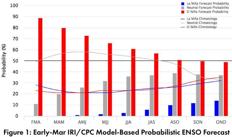
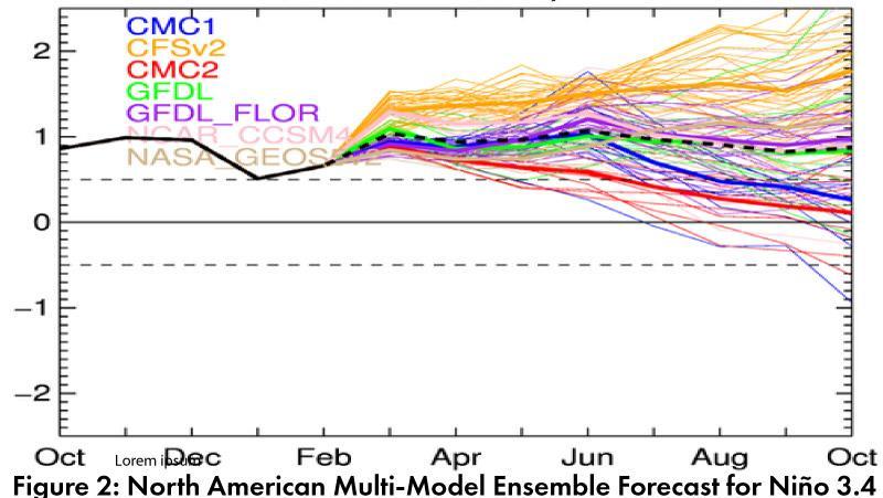
El Niño Tracker: Seasonal outlooks have mostly converged on forecasts that emphasize atmospheric and oceanic conditions consistent with a weak El Niño event. This is expected to last through spring, with a chance for a longer event if these conditions persist through summer and into fall. On Mar. 11, the Japanese Meteorological Agency (JMA) maintained their assertion of the presence of El Niño conditions in the equatorial Pacific and called for a 70-percent chance of these conditions lasting until summer 2019. On Mar. 14, the NOAA Climate Prediction Center (CPC) maintained their El Niño advisory, given the convergence of oceanic and atmospheric conditions, as well as warm subsurface waters on the way, and their outlook jumped to an 80-percent chance of an El Niño lasting through spring (and 60-percent through summer). On Mar. 19, the International Research Institute (IRI) issued an ENSO Quick Look (Fig. 1), highlighting above-average sea surface temperatures (SSTs), warm subsurface waters, and the development of atmospheric conditions over the past few months. On Mar. 19, the Australian Bureau of Meteorology updated to an El Niño Alert, re ecting increasing chances of an El Niño developing over spring and summer. The North American Multi-Model Ensemble (NMME) points toward a weak El Niño at present lasting through at least summer 2018 (Fig. 2).
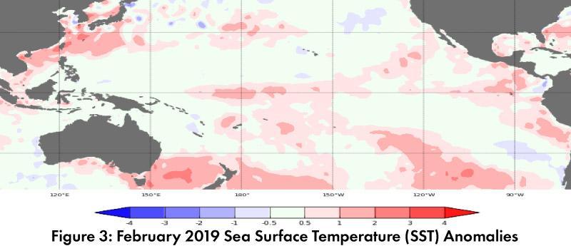
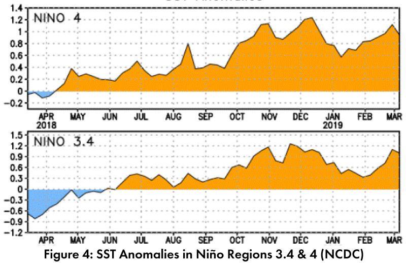
Summary: With sea surface temperatures (SSTs) above-average across the equatorial Paci c (Figs. 3-4), warm sub-surface waters supplementing these anomalies, and atmospheric conditions demonstrating a clearer connection – El Niño appears locked in at this point. Yet for the Southwest, we are rapidly approaching months that are typically warmer and drier, so the impact of this late arrival remains to be seen. Will this alter our current trajectory, or have we already been observing borderline weak El Niño impacts? Or, is this a wetter winter within the range of normal that just happened to occur as a weak El Niño nally spun up? In the Southwest, it can be hard to say, as El Niño events are associated with increased chances for above-normal winter precipitation, but weak events demonstrate limited correlation with above-normal precipitation. Considering the accumulated drought conditions affecting the Southwest, whatever ends up being given credit for these wetter and cooler than average conditions - even if it ends up only being a ‘normal’ southwestern winter – is welcome.


