Southwest Climate Outlook October 2018 - Climate Summary
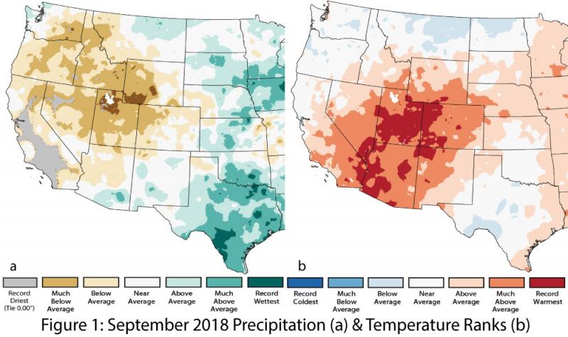
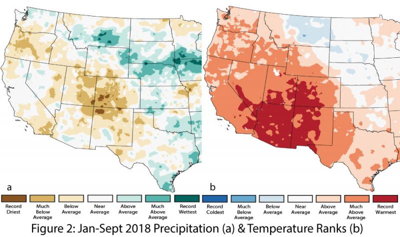
Precipitation and Temperature: Precipitation in September ranged from average to above average in New Mexico and from below average to much-above average in Arizona (Fig. 1a). September temperatures were warm throughout the region, ranging from much-above average to record warmest in Arizona and mostly above average to much-above average in New Mexico (Fig. 1b). Year-to-date precipitation was mostly average to below average in Arizona and New Mexico (Fig. 2a). Year-to-date temperatures were much-above average to record warmest across the region (Fig. 2b).
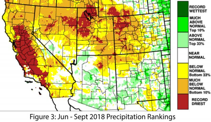
Monsoon Recap: The cumulative rainfall totals for June 15 – Sept. 30 blunt some of the monsoon variability seen across Arizona and New Mexico. Most of the region recorded normal to above-normal precipitation except for the Four Corners area, where rainfall ranged from below normal to record driest (Fig. 3). A closer look at statewide monthly totals and specific weather stations highlights the variability of the monsoon (see Monsoon Recap for details).
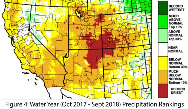
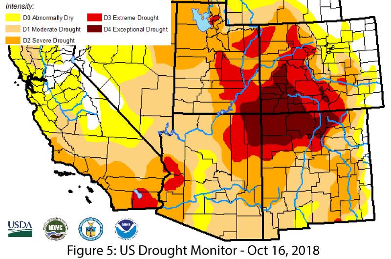
Drought: Water-year precipitation (Oct. 1 to present) was below normal to record driest for most of Arizona and ranged from above normal to record driest in New Mexico. More broadly, most of the Southwest experienced below normal or lower precipitation totals, with the driest conditions centered on the Four Corners region (Fig. 4). Recent iterations of the US Drought Monitor have identified drought category improvements in southern Arizona as a result of tropical storm activity in early October (Fig. 5). This highlights the ongoing challenge of monitoring drought in an arid region, as extreme precipitation events can certainly help some locations make up their cumulative precipitation deficits, but it is less clear how localized intense precipitation and flooding improves long-term drought conditions. Despite the short-term upticks in precipitation observed locally, most of the Southwest is still affected by longer-term, cool-season precipitation deficits that have accumulated over the past few decades under persistent annual drought conditions in the Southwest.
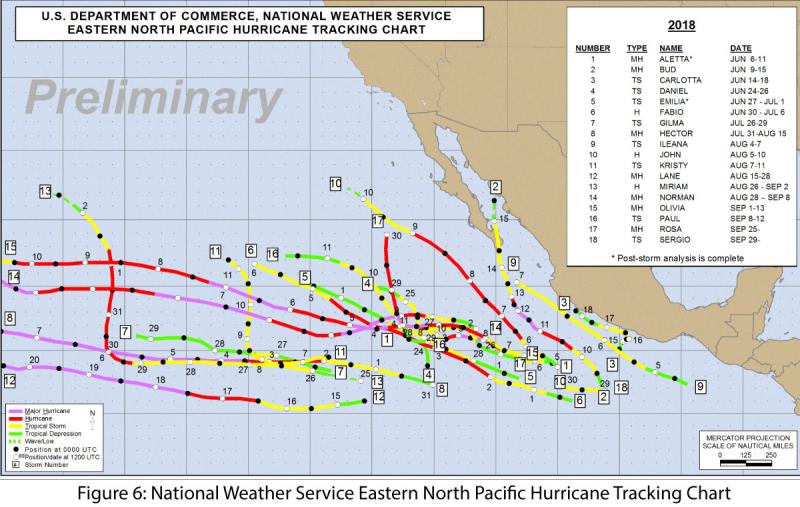
Tropical Storms: The eastern North Pacific hurricane season has been very active, with 20 named storms at the time of this writing (Fig. 6), including nine major hurricanes (category 4 or above). NOAA forecasted 14-20 named storms and seven major hurricanes, so we’re now at the high end of their prediction, and the season doesn’t end until Nov 30. This year is currently tied with 1992 for the most intense Pacific hurricane season on record, with an Accumulated Cyclonic Energy of 295, and could break the record if any additional storms develop or persist. In the Southwest, recent notable events include widespread precipitation from tropical depression Nineteen-E Sept. 19-20, the swath of extreme precipitation observed with Tropical Storm Rosa in early October, and more widespread precipitation activity linked to Tropical Storm Sergio in mid-October (see Tropical Storm Activity Tracker).
El Niño Tracker: Oceanic and atmospheric indicators are still within the range of ENSO-neutral conditions, but they are very likely moving towards an El Niño event in 2018. This shift is reflected in recent models and forecasts, which identify an approximately 75-percent chance of an El Niño event by the end of 2018. Most forecasts are calling for a weak event but a few suggest that a moderate event could develop (see El Nino tracker for details).
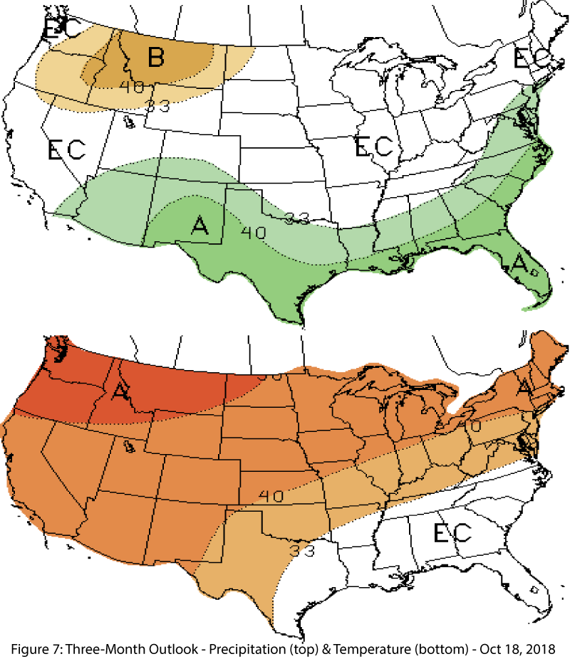
Precipitation and Temperature Forecast: The three-month outlook for November through January calls for increased chances of above-normal precipitation in Arizona and New Mexico (Fig. 7, top), and increased chances of above-average temperatures for the entire western United States (Fig. 7, bottom).
Online Resources
- Figures 1-2 - National Centers for Environmental Information - ncei.noaa.gov
- Figures 3-4 - Western Regional Climate Center - wrcc.dri.edu
- Figure 5 - U.S. Drought Monitor - droughtmonitor.unl.edu
- Figure 6 - NWS National Hurricane Center - nhc.noaa.gov
- Figure 7 - NOAA - Climate Prediction Center - cpc.ncep.noaa.gov

