Southwest Climate Outlook May 2018 - Climate Summary
Originally published in the May issue of the CLIMAS Southwest Climate Outlook
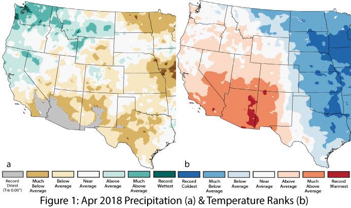
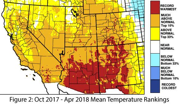
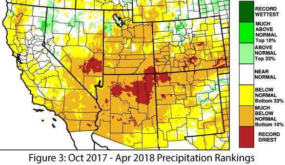
Precipitation and Temperature: The Southwest was characterized by below-average precipitation in April, ranging locally from record driest to near average (Fig. 1a). Temperatures were mostly above average for yet another month, with record-warm conditions along the eastern third of Arizona and the edge of western New Mexico, but also with a band of average to below-average temperatures on the eastern edge of New Mexico (Fig. 1b). Water-year precipitation to date (Oct 2017 – Apr 2018) ranged from below average to record dry in Arizona, and from above average to record dry in New Mexico (Fig. 2). Temperatures for the same period reached record highs across most of southern Arizona and southwestern New Mexico and were above average to much-above average across the rest of the region (Fig. 3).
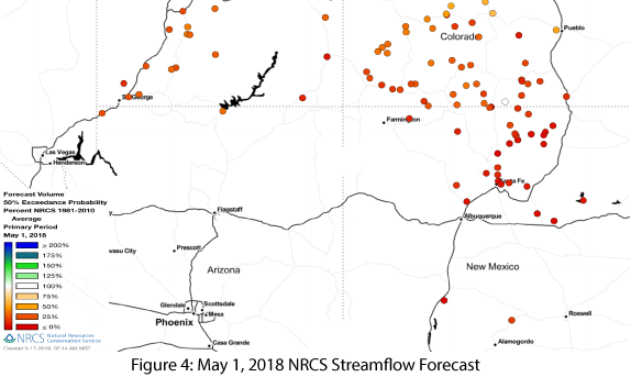
Snowpack & Streamflow Forecast: Snow water equivalent (SWE) values remained well-below average across the Southwest, although in Arizona and most of New Mexico, few stations had any snowpack and SWE to report. Warm and dry conditions continue to affect streamflow and runoff timing: streamflow forecasts for Arizona and New Mexico are all well-below average (Fig. 4).
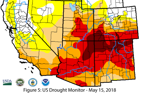
Drought: Drought-designated areas continue to expand from last month. In the May 15 U.S. Drought Monitor, Arizona and New Mexico saw further increases in the extent and intensity of drought (Fig. 5), particularly in northeastern Arizona and northern New Mexico. These designations reflect short-term precipitation deficits, above-normal temperatures at monthly and seasonal timescales, and longer-term drought that tracks the cumulative effect of extended periods of warmer- and drier-than-normal conditions. May is typically dry in the Southwest, so normal conditions may not alter drought designations much. The next realistic hope for drought relief is the summer monsoon, but the extent of its impact will depend on when it starts and how much precipitation actually falls.
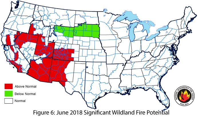
Wildfire: The National Significant Wildland Fire Potential Outlook for June identified above-normal wildland fire risk across the Southwest except for eastern New Mexico and far northwestern Arizona (Fig. 6). Warm and dry conditions this winter, in conjunction with above-normal fine-fuel loading and continuity, are major drivers of the elevated risk. The July outlook takes into account the anticipated decrease in fire risk during the monsoon and returns to normal wildland fire potential for most of the Southwest. However, a late start to the monsoon could extend the fire risk window, while an early start could help end it sooner.
ENSO & La Niña: The La Niña event is officially over with a return to neutral conditions across oceanic and atmospheric indicators, although the event was waning for the past few months. We have entered the period of the spring “predictability barrier” during which there is limited ability to forecast the ENSO status for the next several months. Climatological patterns suggest relatively equal chances of either an El Niño event starting up or ENSO neutral conditions continuing, with virtually zero chance for a La Niña event. By mid-summer, the forecasts and outlooks will have better information to determine the ENSO trajectory for late summer and fall.
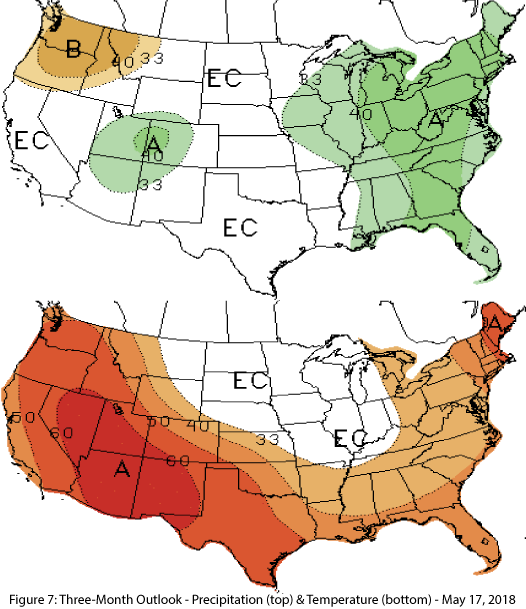
Precipitation and Temperature Forecast: The three-month outlook for June through August calls for equal chances of above- or below-average precipitation in most of Arizona and New Mexico, with the exception of northern Arizona and northwestern New Mexico, where there are increased chances of above-normal precipitation (Fig. 7, top). The outlook calls for increased chances of above-average temperatures (Fig. 7, bottom) for the entire western United States.
Online Resources
- Figure 1 - National Centers for Environmental Information - ncei.noaa.gov
- Figures 2-3 - Western Regional Climate Center - wrcc.dri.edu
- Figure 4 - Natural Resources Conservation Svc - wcc.nrcs.usda.gov
- Figure 5 - U.S. Drought Monitor - droughtmonitor.unl.edu
- Figure 6 - National Interagency Fire Center - nifc.gov
- Figure 7 - NOAA - Climate Prediction Center - cpc.ncep.noaa.gov

