Southwest Climate Outlook June 2018 - Climate Summary
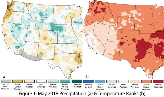
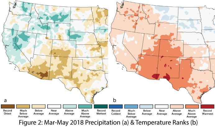
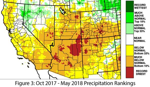
Precipitation and Temperature: The Southwest was characterized by below-average precipitation in May, ranging locally from record driest to near average (Fig. 1a). Temperatures were above average to much-above average across most of the Southwest, with small pockets of record-warm conditions in the northwest corner of New Mexico and along the eastern edge of the state (Fig. 1b). The March through May period exhibited similar patterns of mostly drier-than-average to record-dry precipitation (Fig. 2a) and much-above-average to record-warm temperatures (Fig. 2b). Water-year precipitation to date (Oct 2017 – May 2018) highlights how dry most of the region has been at a longer timescale, with below-normal to record-dry conditions across Arizona and above-normal to record-dry conditions in New Mexico (Fig. 3).
Monsoon & Tropical Activity: The Pacific tropical storm season got off to a strong start with Aletta and Bud, the former as an early start to the season in May, and the latter bringing well-above-normal June precipitation to parts of the Southwest (see Monsoon/TS tracker).
Snowpack & Streamflow Forecast: Snow was all but gone from the Southwest by June, and snow water equivalent (SWE) for the Upper Colorado River Basin remain below average, with only the upper Great Basin and Pacific Northwest having any semblance of above-normal snowpack. Warm and dry conditions continue to affect streamflow and runoff timing – a pattern that extends to the Upper Colorado River Basin, where streamflow forecasts are all well-below average.
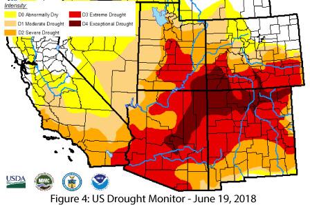
Drought: Drought-designated areas continued to expand from last month. In the June 21 U.S. Drought Monitor, Arizona and New Mexico saw further increases in the extent and intensity of drought (Fig. 4). These designations reflect short-term precipitation deficits, above-normal temperatures at monthly and seasonal timescales, and longer-term drought that tracks the cumulative effect of extended periods of warmer- and drier-than-normal conditions. The surge of tropical storm activity (Bud) in mid-June brought a welcome reprieve from ongoing dry conditions, but the next realistic hope for drought relief is the summer monsoon. The extent of its impact will depend on when it starts and how much (and how regularly) precipitation actually falls.
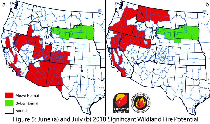
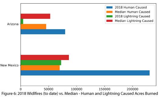
Wildfire: The National Significant Wildland Fire Potential Outlook for June identified above-normal wildland fire risk across the Southwest except for eastern New Mexico and far northwestern Arizona, while the outlook for July calls for the fire risk to return to normal (Fig. 5a-b) in anticipation of monsoon moisture abating the risk. Southeastern Arizona and portions of New Mexico received precipitation linked to the remnants of Tropical Storm Bud, but regional patterns are not indicative of an early start to widespread monsoon activity (see Monsoon Tracker). A late start to the monsoon could extend the fire-risk window, especially if long periods of dry lightning—a major ignition risk in June and July—precede precipitation. The region has been relatively fortunate in 2018, with less lightning-caused fire activity than might have been expected (Fig. 6), given the exceptionally warm and dry conditions over the winter and above-normal fine-fuel loading and continuity.
El Niño Tracker: Neutral conditions are present in oceanic and atmospheric indicators, and longer-term outlooks indicate increasing chances of an El Niño event in 2018. Both the timing and the probability of an El Niño event are still uncertain, but most forecasts highlighted an increased chance of El Niño forming compared to last month, with now nearly twice the chance compared to ENSO neutral conditions (see ENSO tracker). Notably, there is nearly zero chance of a La Niña event in 2018.
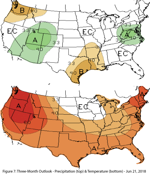
Precipitation and Temperature Forecast: The three-month outlook for June through August calls for increased chances of above-normal precipitation in Arizona and western New Mexico, with equal chances in central and eastern New Mexico (Fig. 7, top). The outlook calls for increased chances of above-average temperatures for the entire Southwest (Fig. 7, bottom).
Online/Image Resources
- Figures 1-2 -National Centers for Environmental Information -ncei.noaa.gov
- Figure 3 - Western Regional Climate Center - wrcc.dri.edu
- Figure 4 - Climate Assessment for the SW - climas.arizona.edu
- Figure 5 - U.S. Drought Monitor - droughtmonitor.unl.edu
- Figure 6 - National Interagency Fire Center - nifc.gov
- Figure 7 - NOAA - Climate Prediction Center - cpc.ncep.noaa.gov

