Southwest Climate Outlook July 2018 - Climate Summary
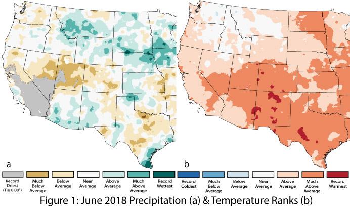
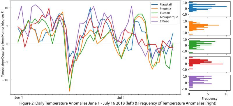
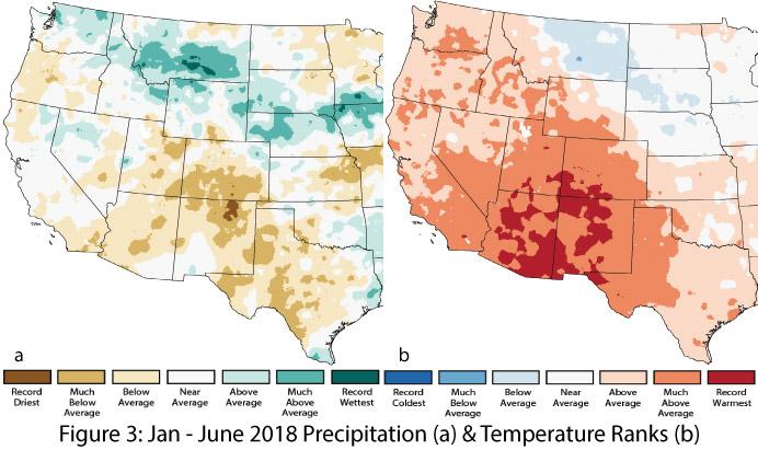
Precipitation and Temperature: Precipitation in June ranged from record driest to much-above average (Fig. 1a); the wetter-than-average areas were those impacted by the remnants of Hurricane Bud in mid-June. June is typically dry, barring an early onset of monsoon activity, so any pre-monsoon precipitation will boost percentile rankings. June temperatures were warmer than average across all of Arizona and New Mexico (Fig. 1b), including record-warm conditions in eastern Arizona and central New Mexico. Notably, unlike recent years, no extreme heat waves affected the region in June, although sustained warmer-than-average temperatures did occur throughout the month and into July (Fig. 2). Year-to-date precipitation and temperature reveal average to record-driest precipitation and much-above-average to record-warmest temperatures (Fig. 3a-b).
Monsoon Tracker: The monsoon is off and running with widespread activity across Arizona and western New Mexico. This uptick in activity is linked to increases in atmospheric moisture (dewpoint, precipitable water), wind patterns, and atmospheric circulations that must come together for storm development and progression. As is often the case in the Southwest, the location and intensity of rainstorms have varied considerably across time and space, with a wide range in observed precipitation across the entire region, and sometimes even within the same metropolitan area (see Monsoon Tracker for details).
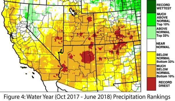
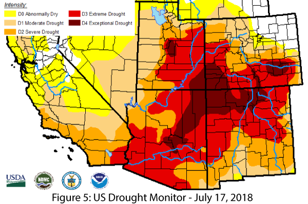
Drought: Water-year precipitation to date reveals persistent deficits across most of Arizona and much of New Mexico, including record-dry conditions across the upper third of both states (Fig. 4). With the onset of the monsoon, precipitation and humidity have increased considerably, bringing a stark contrast to the dry conditions of much of the last 12 months. This highlights an annual conundrum: how much does monsoon precipitation mitigate drought conditions in the Southwest? The question centers on the nature of monsoon precipitation, which is often of high intensity and subject to runoff and evaporation, and has a high degree of spatial variability, resulting in “winners” and “losers” in terms of monthly and seasonal totals. The July 19 USDM does not reveal much in the way of improved drought conditions in most of Arizona and New Mexico, as the short-term uptick in precipitation with the onset of the monsoon was not enough to reverse months of precipitation deficits compounded by the impact of warmer- and drier-than-average conditions (Fig. 5).
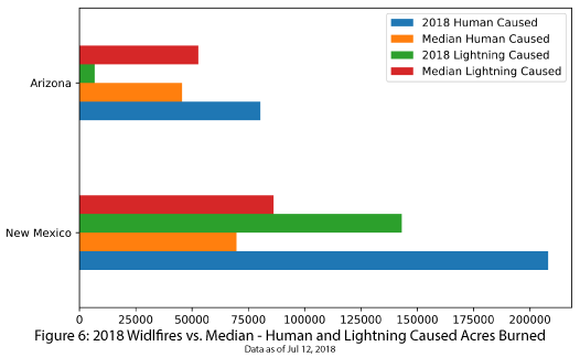
Wildfire: Widespread moisture and monsoon activity helped tamp down fire risk in July. The fire season is not over yet but the period of highest wildfire risk is. Given the widespread dry, windy, and warm conditions observed in the Southwest this winter and spring, fire season was not as catastrophic as some feared it would be, especially in Arizona (see Fig. 6 for a summary).
El Niño Tracker: Neutral conditions are present in oceanic and atmospheric indicators and are expected to remain neutral through summer. Seasonal outlooks indicate increasing chances of an El Niño event in 2018, with El Niño conditions likely to emerge by fall or winter (see El Niño Tracker for details). Above-average winter precipitation is one characteristic of El Niño in the Southwest, but if the event develops earlier rather than later this fall, it also could help enhance eastern Pacific tropical storm activity. This in turn could promote increased precipitation in the Southwest this fall, especially if these tropical storms bend back into the Southwest and drive moisture into the region. By way of comparison, last year—a La Niña year—brought little tropical storm activity to augment precipitation totals for either the monsoon or the fall season.
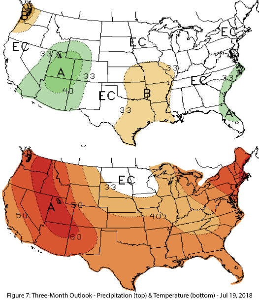
Precipitation and Temperature Forecast: The three-month outlook for July through September calls for increased chances of above-normal precipitation in Arizona and western New Mexico, with equal chances in central and eastern New Mexico (Fig. 7, top). The outlook calls for increased chances of above-average temperatures for the entire Southwest (Fig. 7, bottom).
Online Resources
- Figures 1,3 - National Centers for Environmental Information - ncei.noaa.gov
- Figures 2,6 - Climate Assessment for the SW - climas.arizona.edu
- Figure 4 - Western Regional Climate Center - wrcc.dri.edu
- Figure 5 - U.S. Drought Monitor - droughtmonitor.unl.edu
- Figure 7 - NOAA - Climate Prediction Center - cpc.ncep.noaa.gov

