Southwest Climate Outlook - El Niño Tracker - October 2019
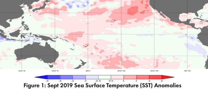
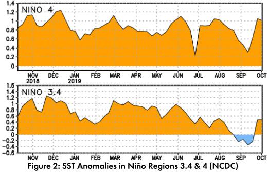
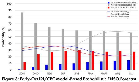
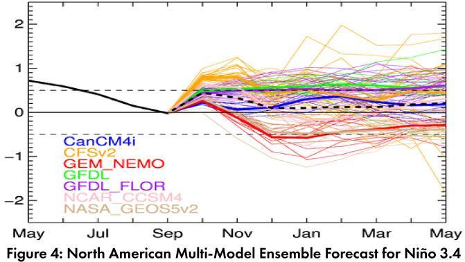
Forecast Roundup: Despite warmer waters in the equatorial Pacific, seasonal outlooks and forecasts based on sea surface temperature (SST) anomalies (Figs. 1-2) and other oceanic and atmospheric indicators, all point to ENSO-neutral conditions lasting through 2019 and into 2020. On Oct 10, the Japanese Meteorological Agency (JMA) highlighted lingering warmer-than-normal SSTs in the western equatorial Pacific, and maintained their call for a 60-percent chance of ENSO-neutral conditions to continue until winter 2019-2020. On Oct 10, the NOAA Climate Prediction Center (CPC) issued their ENSO diagnostic discussion with an inactive alert status, and focused on neutral conditions across the oceans and atmosphere. They called for an 85-percent chance of ENSO-neutral conditions persisting through fall 2019, and a 55- to 60-percent chance of ENSO-neutral through spring 2020. On Oct 10, the International Research Institute (IRI) issued an ENSO Quick Look (Fig. 3), emphasizing neutral conditions in oceanic and atmospheric indicators. Their models see ENSO-neutral as the most likely outcome, but remain at “slightly higher chances for El Niño than La Niña”. On Oct 15, the Australian Bureau of Meteorology maintained their ENSO Outlook at ‘inactive’ with most oceanic and atmospheric conditions in the range of neutral. The Oct 2019 North American Multi-Model Ensemble (NMME) saw a turn back towards positive SST anomalies, but is forecast to remain within the range of ENSO-neutral through 2019 (Fig. 4).
Summary: ENSO-neutral remains the most likely outcome for 2019 into spring 2020, with oceanic and atmospheric conditions within the range of ENSO-neutral. Seasonal outlooks had been calling for increased chances of above average precipitation and temperatures for late fall and into winter. We originally assumed this was linked to the increased chance of enhanced tropical storm activity in the eastern pacific associated with El Niño, but with a return to ENSO-neutral, El Niño is not a factor. Warmer and (mostly) wetter than normal conditions remain in the seasonal outlooks however (see Fig. 7 on p. 2), although the reason is not entirely clear. November is climatologically relatively dry in the Southwest, so it does not take much precipitation to go above normal, and it may be late season tropical storm activity that is tilting this forecast wet. Tropical storm activity so far has hovered just below average in the eastern Pacific, and in September TS Lorena and TS Mario ushered moisture into the Southwest and interacted with a cutoff low to boost precipitation in southern Arizona (including supercell activity), after a mostly below average monsoon (see Monsoon Tracker on p. 4-6 for details).
Online Resources
- Figure 1 - Australian Bureau of Meteorology - bom.gov.au/climate/enso
- Figure 2 - NOAA - Climate Prediction Center - cpc.ncep.noaa.gov
- Figure 3 - International Research Institute for Climate and Society - iri.columbia.edu
- Figure 4 - NOAA - Climate Prediction Center - cpc.ncep.noaa.gov


