Southwest Climate Outlook El Niño Tracker - October 2018
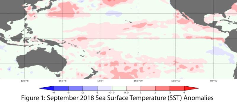
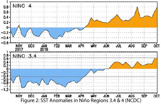
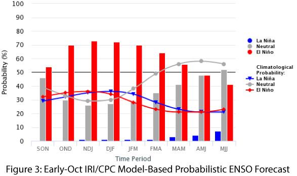
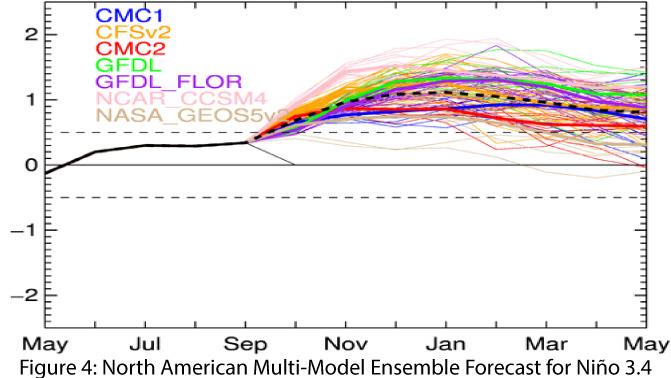
Oceanic and atmospheric conditions are still within the range of ENSO-neutral (Figs. 1-2), but rising sea-surface temperatures (SSTs) and shifting atmospheric conditions are reflected in recent forecasts, which call for an El Niño event forming by the end of 2018 and lasting through the winter. On Oct. 11, the Japanese Meteorological Agency (JMA) identified continued ENSO-neutral conditions, but based on weakening easterlies and warming SSTs forecast a 70-percent chance of El Niño developing this fall. Similarly, on Oct. 9, weakening trade winds and warming oceanic temperatures were the basis for the Australian Bureau of Meteorology to elevate its ENSO Outlook to “El Niño Alert,” with a 70-percent chance of its formation in 2018—three times the normal likelihood. On Oct. 11, the NOAA Climate Prediction Center (CPC) continued its El Niño watch, identifying neutral conditions at present but with a 70- to 75-percent chance of an El Niño event developing this winter. On Oct. 11, the International Research Institute (IRI) issued an ENSO Quick Look, which observed neutral conditions in the oceans and atmosphere now but with trends towards El Niño conditions in oceanic and atmospheric indicators. IRI suggests a nearly 75-percent chance of an El Niño event by the end of 2018 (Fig. 3). The North American Multi-Model Ensemble (NMME) stabilized over the past few months but continues to point toward a weak-to-borderline moderate El Niño by the end of the year (Fig. 4).
Summary: Despite persistent ENSO-neutral conditions this summer and early fall, outlooks and forecasts indicate the likely formation of an El Niño event before the year ends. These forecasts are informed by long-term climatological patterns and recent trends towards warming SSTs and shifting atmospheric conditions. There is effectively no chance of a La Niña event forming this winter, but ENSO-neutral conditions remain a possibility, albeit increasingly unlikely. The recent warming in SSTs and shifts in atmospheric circulation have kindled discussion about the possible intensity–rather than merely the existence–of this El Niño event. Cool-season precipitation totals (Oct – Mar) in the Southwest during previous El Nino events reveal considerable variability under weak events, including some drier-than-average seasonal totals. However, under moderate-intensity events, drier-than-average cool seasons have been rare. While it is too early to even call this an El Niño year with 100 percent certainty, much less predict its eventual intensity, we wait with great anticipation anything that might increase our chances of more winter rain. The sample size is small, but an El Niño of at least moderate intensity has been one of the more surefire pathways to a wetter-than-average Southwest winter (setting aside 2016 as the obvious outlier).
Online Resources
- Figure 1 - Australian Bureau of Meteorology - bom.gov.au/climate/enso
- Figure 2 - NOAA - Climate Prediction Center - cpc.ncep.noaa.gov
- Figure 3 - International Research Institute for Climate and Society - iri.columbia.edu
- Figure 4 - NOAA - Climate Prediction Center - cpc.ncep.noaa.gov


