Southwest Climate Outlook August 2020 - Climate Summary
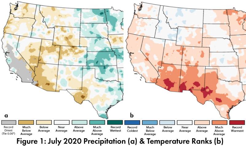
Monthly Precipitation and Temperature: July precipitation ranged between record driest and average in most of Arizona and between below average and above average in most of New Mexico (Fig. 1a). July temperatures were much above average or record warmest in most of Arizona and New Mexico (Fig. 1b). The daily average temperature anomalies for Jul 1 – Aug 15 (Fig. 2) highlight the fluctuations at select stations around the region.
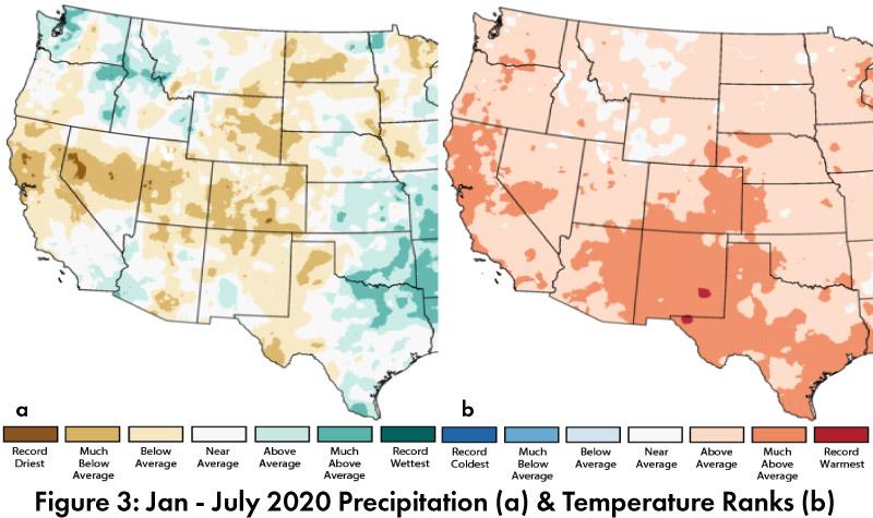
Seasonal Precipitation and Temperature: 2020 precipitation (Jan-Jul) ranged from below average to above average in Arizona and from much below average to above average in New Mexico (Fig. 3a). 2020 temperatures were above average to much above average across the U.S. Southwest (Fig. 3b).
Water Supply: Water year precipitation to date (Oct 2019 – Jul 2020) is above normal to much above normal across most of southern and central Arizona and New Mexico (along with west Texas and southern California), while the Four Corners, northern New Mexico, and southern Colorado are below normal or much below normal (Fig. 4). Many of the reservoirs in the region are at or above the values recorded at this time last year, but most are below their long-term average (see Arizona and New Mexico reservoir storage).
Drought: The Aug 11 U.S. Drought Monitor (USDM) expanded drought characterizations across Arizona and New Mexico, with expansions of moderate (D1), severe (D2), and extreme drought (D3) that reflect the below average monsoon precipitation as well as accumulated long term precipitation deficits (Fig. 5).
Wildfire: 2020 is turning out to be an active fire year in Arizona. Notable fires include the Bighorn Fire near Tucson, the Sawtooth and Bush Fires near Phoenix, and the Mangum fire in northern Arizona. In Arizona, wildfire acres burned for 2020 are well above mean and median (1990-2015), and have exceeded the totals for lightning and human-caused fires in the past five years. New Mexico remains below average in 2020, especially for human caused wildfire (Fig. 6, data updated as of Aug 17).
ENSO Tracker: Conditions are expected to remain ENSO-neutral through summer 2020, with increased chances for a La Niña event this fall (see ENSO-tracker).
Precipitation and Temperature Forecast: The three-month outlook for Sept through Nov calls for equal chances of above- or below-average precipitation in most of Arizona, and an increased chance of below-normal precipitation in much of New Mexico (Fig. 7, top). The three-month temperature outlook calls for increased chances of above normal temperatures across most of the western U.S. and northern Mexico (Fig. 7, bottom).
Online Resources
- Figures 1, 3 - National Centers for Environmental Information - ncei.noaa.gov
- Figure 2, 6 - Climate Assessment for the Southwest - climas.arizona.edu
- Figure 4 - West Wide Drought Tracker - wrcc.dri.edu/wwdt
- Figure 5 - U.S. Drought Monitor - droughtmonitor.unl.edu
- Figure 7 - International Research Institute for Climate and Society - iri.columbia.edu


