Southwest Climate Outlook - El Niño Tracker - July 2019
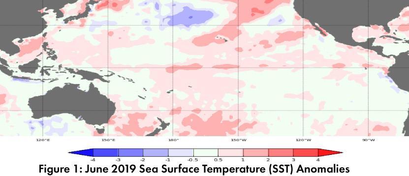
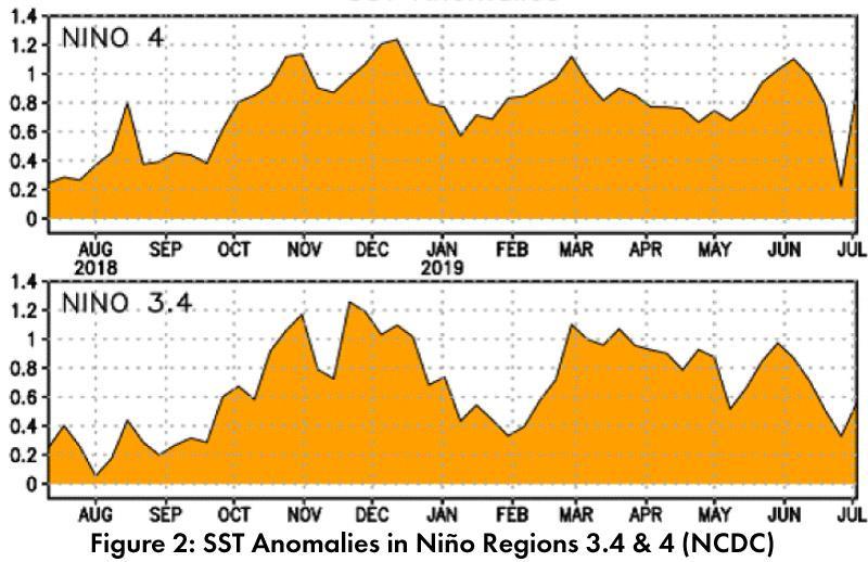
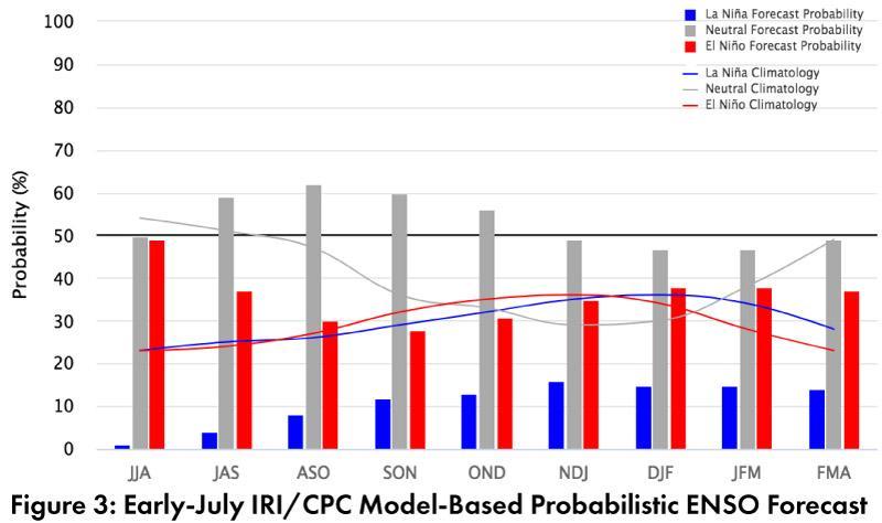
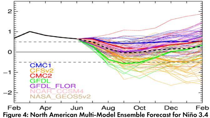
Forecast Roundup: Seasonal outlooks and forecasts focused on sea surface temperature (SST) anomalies and other oceanic and atmospheric indicators, all of which had generally remained consistent with a weak El Niño event (Figs. 1-2), at least until recently. On July 9, the Australian Bureau of Meteorology ended their ENSO Outlook and returned to ‘inactive’ status, identifying ENSO-neutral as the most likely outcome in 2019. On July 10, the Japanese Meteorological Agency (JMA) identified the end of this El Niño event, mostly due to the rapid dissipation of SST anomalies, as well as the return to normal for other atmospheric indicators. They called for a 60-percent chance of ENSO-neutral conditions to continue into Fall 2019. On July 11, the NOAA Climate Prediction Center (CPC) maintained their El Niño advisory based on the SST anomalies, but trends in oceanic and atmospheric conditions led them to expect this event would transition to ENSO-neutral in the next few months. On July 11, the International Research Institute (IRI) issued an ENSO Quick Look (Fig. 3), highlighting above-average SSTs consistent with a weak El Niño, but with most models predicting a transition to ENSO-neutral status by the end of summer. The North American Multi-Model Ensemble (NMME) shifted considerably in the last month, and now points towards a rapid decline to ENSO-neutral status by early fall (Fig. 4).
Summary: El Niño conditions are still within the range of a weak event based on SST anomalies, but most forecasts and outlooks describe this event as over, or that it will be soon. This is a quick shift compared to forecasts from the last few months, which identified the persistence of El Niño through 2019 as the most likely scenario, based on SST anomalies and other oceanic and atmospheric indicators. The swing towards ENSO-neutral was tied to the rapid dissipation of warmer waters in the ocean, and a return to mostly normal atmospheric conditions. Seasonal outlooks had been calling for above average precipitation in late summer and early fall, likely tied to the increased chance of enhanced tropical storm activity in the eastern pacific associated with El Niño. Now that a return to ENSO-neutral is all but certain the role that El Niño might have played in enhancing pacific tropical storms is less relevant. This does not necessarily mean there is an increased chance of drier than normal conditions, but it does mean that one source of moisture and storm activity that has tended to bring increased chances of precipitation into the Southwest, especially in late summer and early fall, is effectively off the table.
Online Resources
- Figure 1 - Australian Bureau of Meteorology - bom.gov.au/climate/enso
- Figure 2 - NOAA - Climate Prediction Center - cpc.ncep.noaa.gov
- Figure 3 - International Research Institute for Climate and Society - iri.columbia.edu
- Figure 4 - NOAA - Climate Prediction Center - cpc.ncep.noaa.gov


