Southwest Climate Outlook - El Niño Tracker - April 2019
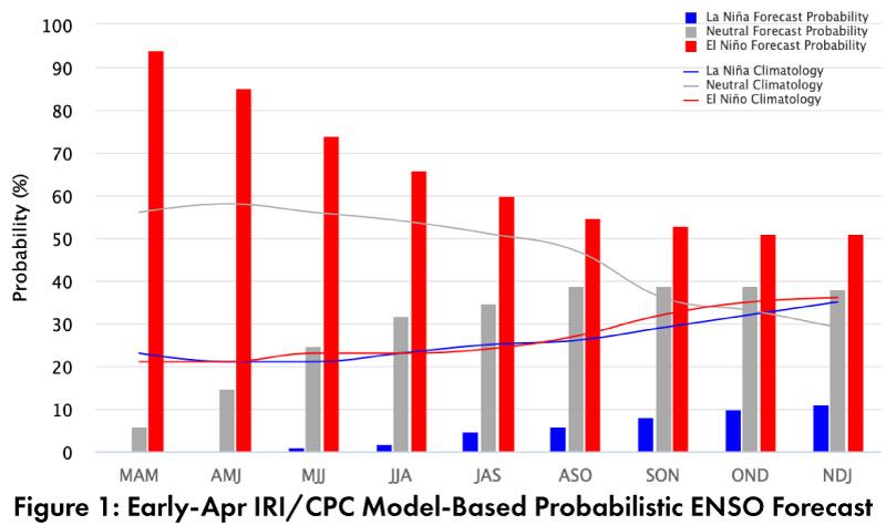
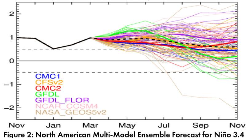
El Niño Tracker: Seasonal outlooks and forecasts emphasize clear atmospheric and oceanic conditions that are consistent with a weak El Niño event, and the discussion has shifted to how long the event will last. On Apr. 10, the Japanese Meteorological Agency (JMA) highlighted that El Niño conditions had persisted in March, and with an 80-percent chance of these conditions lasting until summer. On Apr. 11, the NOAA Climate Prediction Center (CPC) maintained their El Niño advisory, identifying both oceanic and atmospheric conditions consistent with a weak El Niño event. Their outlook maintained a 65-percent chance of El Niño lasting through summer, and 50- to 55-percent of it lasting through fall. On Apr. 11, the International Research Institute (IRI) issued an ENSO Quick Look (Fig. 1), highlighting above-average sea surface temperatures (SSTs) and atmospheric conditions consistent with El Niño over the past few months. On Apr. 16, the Australian Bureau of Meteorology elevated their tracker to an El Niño alert, with a 70-percent chance of an El Niño event in the coming months. The North American Multi-Model Ensemble (NMME) points toward a weak El Niño lasting into fall 2019 (Fig. 2).
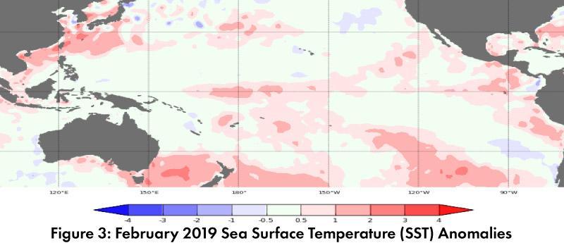
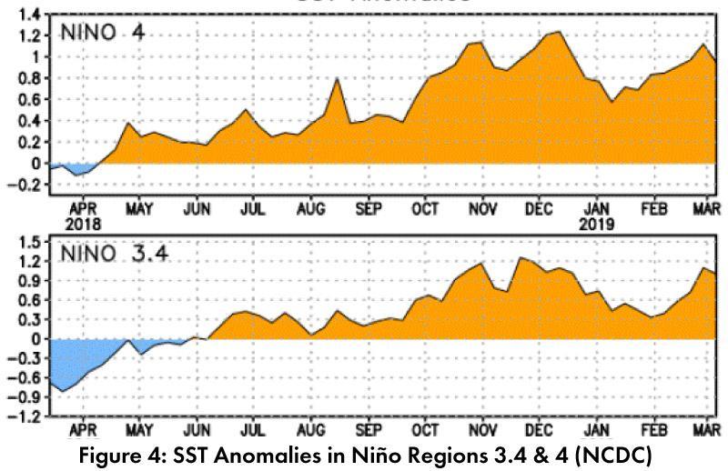
Summary: Sea surface temperatures (SSTs) are above-average across most of the equatorial Pacific (Figs. 3-4) and atmospheric conditions further indicate an established El Niño. The event officially met the diagnostic criteria at the end of March, with five consecutive months or greater where the 3-month SST anomalies were above the threshold of 0.5 C. What does this mean for the region? The first three months of 2019 support the idea that El Niño brings enhanced precipitation to the region (see Fig. 2 on p. 2), but we are also approaching a warmer and drier time of year, so there is less of a precipitation signal to influence. El Niño conditions are also associated with enhanced eastern Pacific tropical storm activity, which could see tropical storms increase our warm season precipitation totals in direct ways (i.e. storms that push into the region) or that provide additional moisture and instability that enhances monsoon activity. The uncertainty associated with forecasts during the so called “spring predictability barrier” make predictions more speculative than certain, but the persistence of an El Niño would seem to suggest additional opportunities for precipitation events over the warm season. These additional opportunities could augment monthly and seasonal totals, and depending on timing and intensity, help mitigate wildfire risk or boost reservoir storage.
Online Resources
- Figure 1 - International Research Institute for Climate and Societyiri.columbia.edu
- Figure 2 - NOAA - Climate Prediction Center - cpc.ncep.noaa.gov
- Figure 3 - Australian Bureau of Meteorology - bom.gov.au/climate/enso
- Figure 4 - NOAA - Climate Prediction Center - cpc.ncep.noaa.gov


