Southwest Climate Outlook April 2019 - Climate Summary
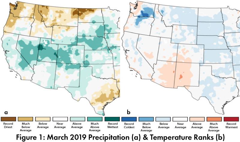
March Precipitation and Temperature: March precipitation was average to above-average across most of Arizona, New Mexico and west Texas, while the upper basin of the Colorado River was much above-average (Fig. 1a). March temperatures were average to above-average in Arizona and New Mexico, despite most of the United States being average to below-average (Fig. 1b).
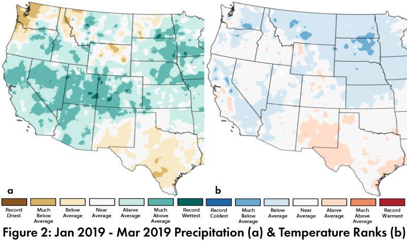
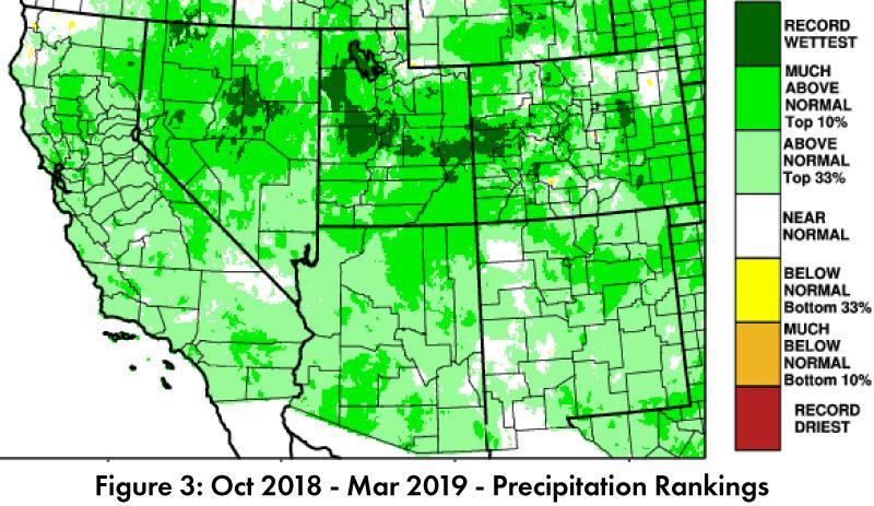
Seasonal Precipitation and Temperature: Jan-Mar precipitation demonstrated a distinct pattern; Arizona and most of the Southwest recorded above-average to much above-average precipitation, while most of New Mexico and west Texas were average to below-average (Fig. 2a). Temperatures for the same period were average to above-average in New Mexico and west Texas, and average to below-average in Arizona and much of the rest of the Southwest (Fig. 2b). Water year precipitation (since Oct. 1) highlights wetter-than-average conditions in the west, with most of Arizona and New Mexico above normal (top 33-percent) or much above-normal (top 10-percent)(Fig. 3).
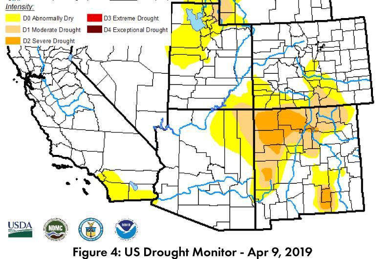
Drought: The Apr. 9 U.S. Drought Monitor (USDM) continues to show improvements in drought conditions in the western United States. Arizona is mostly clear of drought designations, and the intense drought in the four corners region and northern New Mexico have shown additional improvements in the USDM drought categorization compared to last month (Fig. 4).
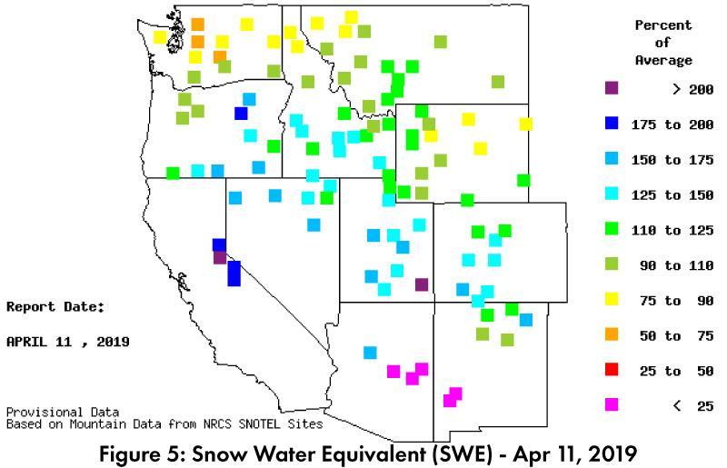
Snowpack & Water Supply: Snow water equivalent (SWE) for stations in southern and central Arizona and New Mexico are below 25-percent of average, although late season calculations can be deceptive given low average values. The northern (higher elevation) stations in AZ and NM range from 110- to over 200-percent of average (Fig. 5), and the lower Colorado River Basin stations range from 125- to over-200 percent of average (see April 2019 Streamflow Forecast).
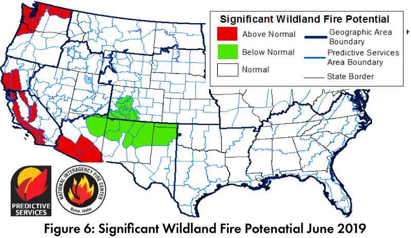
Wildfire, Health, and Safety: Wildfire risk maps reflect the wet winter, with normal to below-normal fire risk in the Southwest in May, but above-normal risk across southern Arizona in June (Fig. 6), an increase tied to concerns over senescence of abundant fine fuels in lower elevations. Wet winter conditions and a warm spring also catalyzed a tremendous wildflower season in the Southwest, although allergy sufferers will note the trade-offs associated with air quality and abundant pollen.
El Niño Tracker: Atmospheric and oceanic conditions are in line with a weak El Niño, and the sea surface temperature (SST) anomalies officially reached the threshold for an El Niño event spanning from late 2018 to present. The current discussion is focused on when these conditions might revert to normal, likely in mid-to-late 2019, but with the possible persistence of this El Niño through 2019 and into early 2020 (see El Nino Tracker).
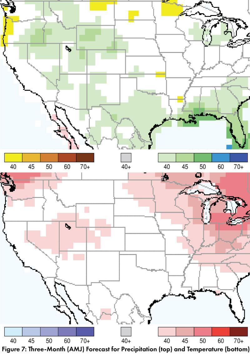
Precipitation and Temperature Forecast: The three-month outlook for May through July calls for increased chances of above-normal precipitation in eastern Arizona and western New Mexico, and increased chances of below-normal precipitation in western Arizona, eastern New Mexico, and west Texas (Fig. 7, top). The three-month temperature outlook calls for equal chances of normal, above-normal, and below-normal temperatures across Arizona, New Mexico, and Northern Mexico (Fig. 7, bottom).
Online Resources
- Figures 1-2 - National Centers for Environmental Information - ncei.noaa.gov
- Figure 3, 5 - Western Regional Climate Center - wrcc.dri.edu
- Figure 4 - U.S. Drought Monitor - droughtmonitor.unl.edu
- Figure 6 - National Interagency Fire Center - droughtmonitor.unl.edu
- Figure 7 - International Research Institute for Climate and Society - iri.columbia.edu

