Southwest Climate Outlook - El Niño Tracker - February 2019
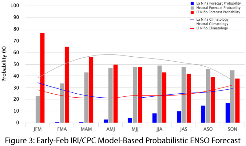
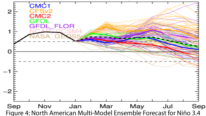
After months of El Niño on the horizon (but each month not appearingto get any closer), forecasters have identi ed the convergence ofatmospheric and oceanic conditions that indicate the presence of a weak El Niño event. This is expected to last through spring, although there is not complete agreement across the international agencies. On Feb. 12, the Japanese Meteorological Agency (JMA) maintained their assertion of the presence of El Niño conditions inthe equatorial Pacific and called for a 70-percent chance of these conditions lasting until summer 2019. On Feb. 14, the NOAA Climate Prediction Center (CPC) switched to an El Niño advisory, given the convergence of oceanic and atmospheric conditions, as well as warm subsurface waters on the way, but their outlook dropped to a 55-percent chance of an El Niño lasting through spring. On Feb.19, the Australian Bureau of Meteorology remained in an El Nino watch, reflecting the increased chance of an El Niño developing over spring and summer. On Feb. 19, the International Research Institute (IRI) issued an ENSO Quick Look, highlighting above-average sea surface temperatures (SSTs), warm subsurface waters, and the development of atmospheric conditions over the past few months. They maintained a 65-percent chance of an El Niño Feb-Apr, and a 50-percent chance Apr-Jun (Fig. 3). The North American Multi-Model Ensemble (NMME) points toward a weak El Niño at present lasting through spring 2018 (Fig. 4).
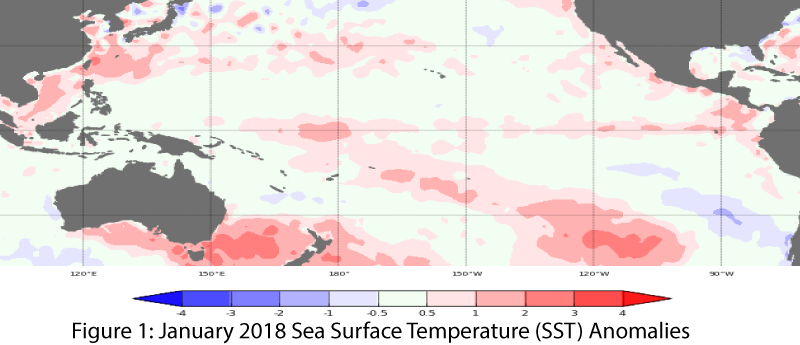
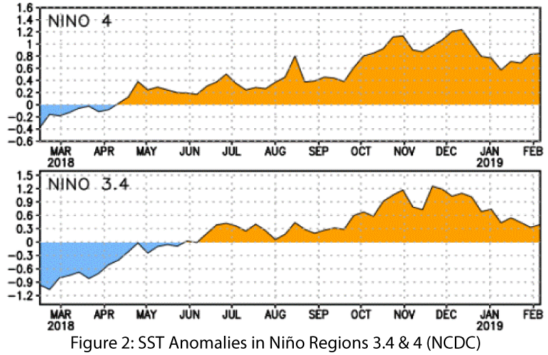
Summary: Sea surface temperatures (SSTs) are still above-average across the equatorial Pacific (Figs. 1-2), and atmospheric conditions finally caught up – the question is: will it be too late for the Southwest, or have we already been observing borderline weak El Niño impacts? The delayed convergence of oceanic and atmospheric conditions was the main factor holding back a more confident outlook, but 2018-2019 looks like it will be classified as a weak El Niño event. In the Southwest, El Niño is associated with increased chances for above-normal winter precipitation, but weak events demonstrate limited correlation with increased precipitation, and some of the wettest winters in the Southwest have been under ENSO-neutral conditions. Winter thus far in parts of Arizona and New Mexico line up with the narrative of winters under El Niño, but direct attribution is challenging given small sample size, aforementioned weak correlations, and the challenges in tracking precipitation anomalies in a region that already sees relatively infrequent rain events in a “wet” year. Additionally, it remains to be seen whether this will turn out to simply be a normal southwestern winter, which only feels wetter and cooler after multiple warm and dry winters altered expectations.
Online Resources
- Figure 1 - Australian Bureau of Meteorology - bom.gov.au/climate/enso
- Figure 2 - NOAA - Climate Prediction Center - cpc.ncep.noaa.gov
- Figure 3 - International Research Institute for Climate and Society - iri.columbia.edu
- Figure 4 - NOAA - Climate Prediction Center - cpc.ncep.noaa.gov
- Equatorial Niño Regions - For more information: ncdc.noaa.gov/teleconnections/enso/indicators/sst/
- Madden Julian Oscilation - For more information: cpc.ncep.noaa.gov/products/precip/CWlink/MJO/mjo.shtml


