Southwest Climate Outlook El Niño Tracker - December 2018
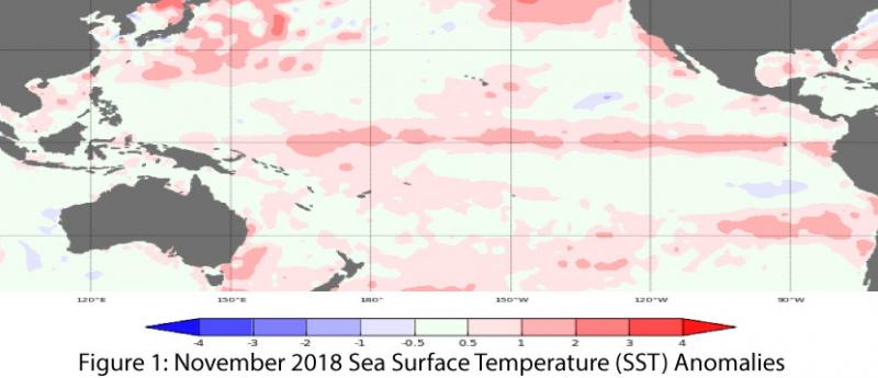
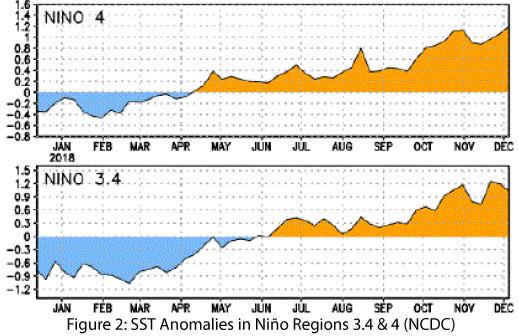
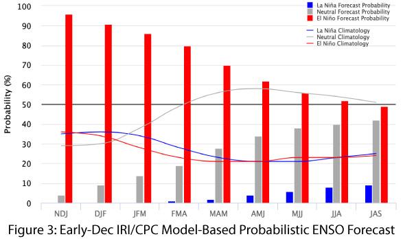
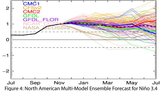
Sea-surface temperatures (SSTs) are above-average across the equatorial Pacific (Figs. 1-2). The coupling between oceanic and atmospheric conditions that typically characterizes an El Nino event continues to be lacking, however, as atmospheric conditions lag behind. Forecasts and outlooks remain bullish on the emergence of an El Niño, and project atmospheric conditions to catch up with oceanic conditions. On Dec. 4, the Australian Bureau of Meteorology highlighted persistent above-average oceanic temperatures, but noted “the atmosphere has yet to show a consistent El Niño signal,” with a lack of coupling between oceanic and atmospheric conditions. The agency maintained its ENSO Outlook at an “El Niño Alert,” with a 70-percent chance of its formation in 2018—three times the normal likelihood. On Dec. 8, the International Research Institute (IRI) issued an ENSO Quick Look that reflected the warmer-than-average oceanic temperatures and lagging atmospheric conditions, but still maintained a greater-than-80-percent chance of an El Niño event by the end of 2018 (Fig. 3). On Dec. 10, the Japanese Meteorological Agency (JMA) maintained its assertion of the presence of El Niño conditions in the equatorial Pacific and called for an 80-percent chance of these conditions lasting through spring 2019. This was despite the general absence of atmospheric conditions consistent with El Niño, but which saw SSTs and sub-surface temperatures above normal across the equatorial Pacific. On Dec. 13, the NOAA Climate Prediction Center (CPC) continued its El Niño watch, stating “despite the above-average ocean temperatures, the overall coupled ocean-atmosphere system remained ENSO-neutral.” CPC’s outlook calls for a 90-percent chance of an El Niño event developing this winter, and a 60-percent chance of it lasting through spring. The North American Multi-Model Ensemble (NMME) continues to point toward a weak-to-moderate El Niño at present, lasting through spring 2018 (Fig. 4).

Summary: Equatorial SSTs (and sub-surface temperatures) are well within the range of an El Niño event, but the ongoing delay in the development of atmospheric conditions is the main factor preventing a more definitive declaration. Based on a limited number of past events from which to compare, this is a late start for an El Niño event. Despite the delay, most forecasts have us on the cusp of an El Niño event that is expected to last through spring 2019. Cool-season precipitation totals (Oct – March) in the Southwest during previous El Niño events reveal considerable variability under weak events, including some drier-than-average seasonal totals. However, under moderate-intensity events, drier-than-average cool seasons have been rare, and it is not difficult to understand why there is eager anticipation for anything that might increase our chances of more winter rain.
Online Resources
- Figure 1 - Australian Bureau of Meteorology - bom.gov.au/climate/enso
- Figure 2 - NOAA - Climate Prediction Center - cpc.ncep.noaa.gov
- Figure 3 - International Research Institute for Climate and Society - iri.columbia.edu
- Figure 4 - NOAA - Climate Prediction Center - cpc.ncep.noaa.gov


