Southwest Climate Outlook December 2018 - Climate Summary
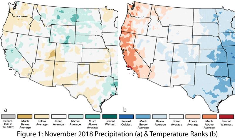
November Precipitation and Temperature: After a wetter- and cooler than-average October, November was closer to long-term averages. Precipitation ranged from average to below-average in Arizona and New Mexico (Fig. 1a). Temperatures were mostly within the range of average, with some below-average observations in eastern New Mexico and the Four Corners region, and with a region of above-average temperatures on the Arizona/California border (Fig. 1b).
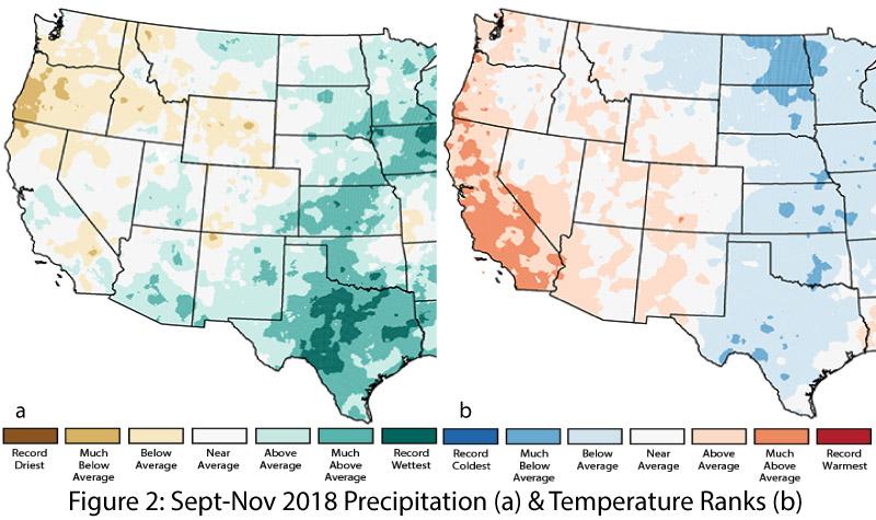
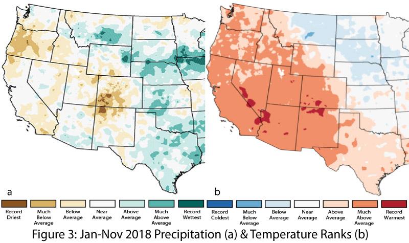
Seasonal & Annual Precipitation and Temperature: Autumn (Sept-Nov) precipitation was average to much-above average, save for a small pocket of below-average rainfall in northwestern New Mexico (Fig. 2a), while temperatures for the same period were average to above average throughout Arizona and New Mexico (Fig. 2b). Year-to-date precipitation ranges from record driest to much-above average, with the marked precipitation deficit continuing in the Four Corners region (Fig. 3a). Year-to-date temperature maps reduce the effect of monthly variability and reveal much-above-average temperatures across most of the Southwest, including some local areas of record-warmest conditions (Fig. 3b).
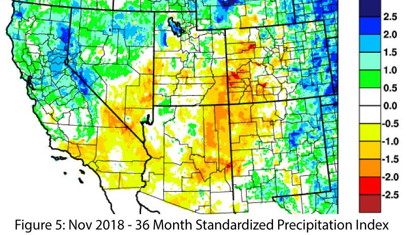
Drought: The Dec. 11 U.S. Drought Monitor (USDM) highlights the presence of drought across the entire Southwest, with persistent and severe drought conditions in the Four Corners region (Fig. 4). Drought in the Southwest poses a challenge in mapping different timescales and intensities of drought on a weekly basis. In a region already characterized by dry conditions, where accumulated precipitation deficits build over seasons and years, these drought characterizations can struggle to capture all of these inputs. The 36-month standardized precipitation index (SPI) for the Southwest (Fig. 5) highlights differential patterns of drought and precipitation deficit.
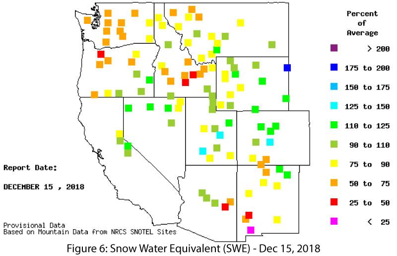
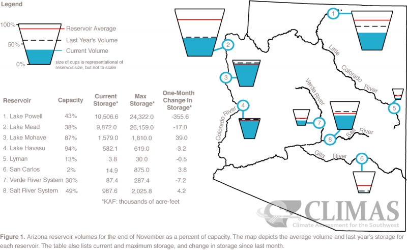
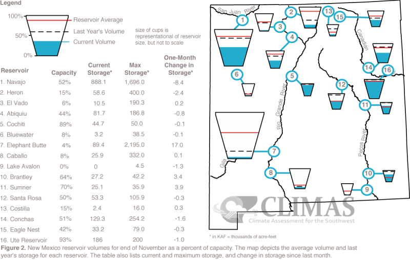
Snowpack & Water Supply: Snow water equivalent (SWE) has fluctuated considerably in southern Arizona and New Mexico this fall, with current values generally near or below average as of Dec. 15 (Fig. 6). Reservoir storage remains a persistent concern, as water levels have been impacted by long-term drought and accumulated precipitation deficit. Most of the reservoirs are at or below their long-term averages, and a few of the Rio Grande reservoirs are especially low (see Arizona and New Mexico reservoir storage).
El Niño Tracker: An El Niño event appears imminent, with oceanic indicators now well into El Niño territory while atmospheric indicators continue to lag behind. Most forecasts noted a lack of coupling between ocean and atmosphere but remain confident of an El Niño event during winter 2018-2019, with forecast probabilities hovering around an 80- to 90-percent likelihood (see El Niño Tracker).
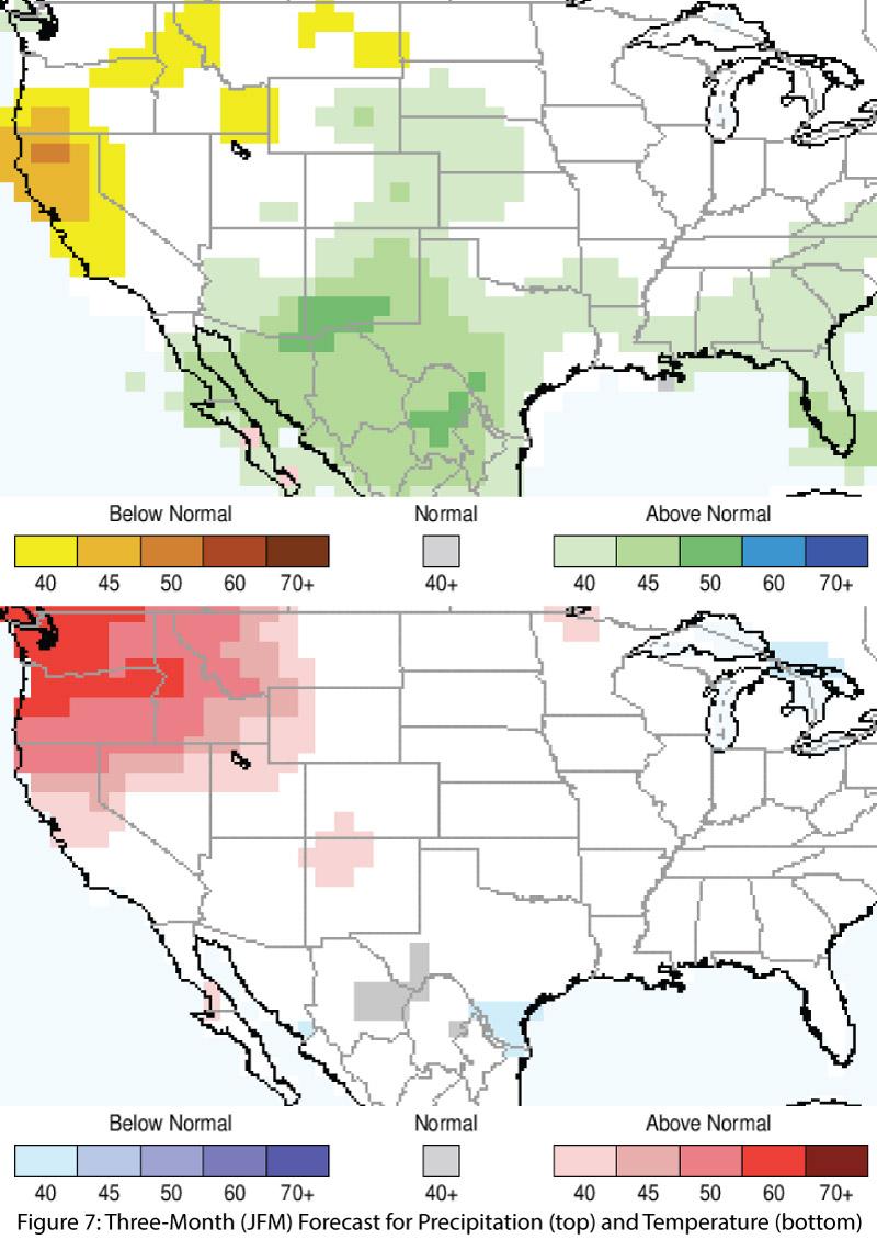
Precipitation and Temperature Forecast: The three-month outlook for December through February calls for increased chances of above-normal precipitation in most of Arizona, New Mexico, and northern Mexico (Fig. 7, top), and mostly equal chances of above- or below-average temperatures for the southwestern United States and northern Mexico (Fig. 7, bottom).
Online Resources
- Figures 1-3 - National Centers for Environmental Information - ncei.noaa.gov
- Figure 4 - U.S. Drought Monitor - droughtmonitor.unl.edu
- Figures 5-6 - Western Regional Climate Center - wrcc.dri.edu
- Figure 7 - International Research Institute for Climate and Society - iri.columbia.edu

