CLIMAS SW Climate Outlook - ENSO Tracker May 2017
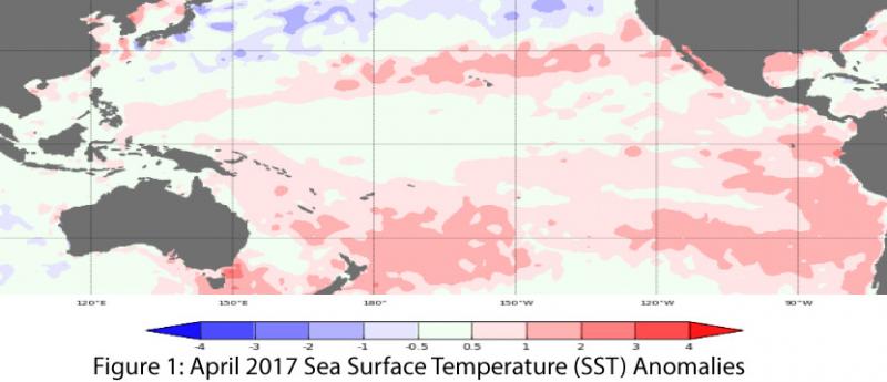
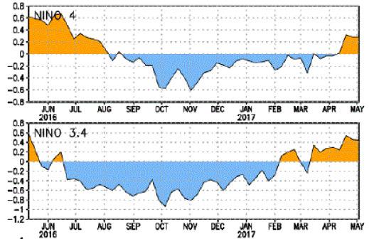
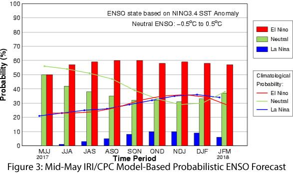
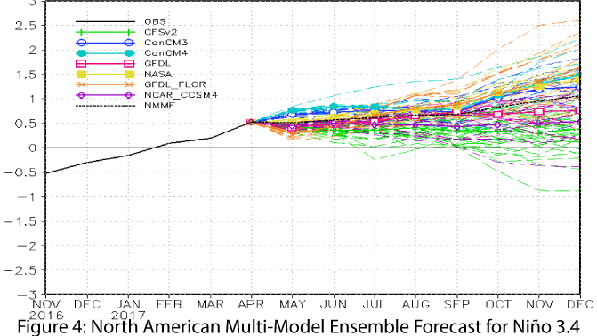
Oceanic and atmospheric indicators are still within the range of neutral (Figs. 1-2), although sea-surface temperatures have more consistently hinted at El Niño compared to atmospheric indicators. Outlooks and forecasts generally agree that ENSO-neutral conditions are likely to remain through the summer, but by mid-to-late 2017, chances of an El Niño event emerging become approximately equal to the chances of continued ENSO-neutral conditions. On May 9, the Australian Bureau of Meteorology maintained its El Niño Watch with a 50-percent chance of an El Niño event, noting warming sea-surface temperatures but less movement towards El Niño in the atmosphere. On May 11, the NOAA Climate Prediction Center (CPC) observed that oceanic and atmospheric conditions were consistent with ENSO-neutral conditions, but expressed some doubt as to whether warming ocean temperatures would last long enough to reach official El Niño status, and whether coupling between ocean and atmosphere would be sufficient to drive an El Niño event. CPC identified nearly equal chances of El Niño (45%) and ENSO-neutral (50%) conditions during fall 2017, with uncertainty regarding El Niño potential attributed to “the lack of a clear shift toward El Niño in the observational data.” On May 12, the Japanese Meteorological Agency (JMA) identified a continuation of ENSO-neutral conditions with a 50-percent chance of El Niño conditions by fall 2017, but like others noted a lack of development in atmospheric conditions that matched the warming sea-surface temperatures. On May 18, the International Research Institute for Climate and Society (IRI) and CPC identified a 60-percent chance of an El Niño in 2017 (Fig. 3) with “dynamical models showing weak El Niño, while statistical (models) predict (an) even weaker event”. The North American Multi-Model Ensemble (NMME) is borderline weak El Niño as of May 2017, but the model spread indicates a wide range of possible outcomes for the rest of 2017 (Fig. 4), clustered mostly around ENSO-neutral and weak El Niño conditions, paralleling the uncertainty in the CPC and IRI/CPC outlooks.
Summary: The lack of clear atmospheric indicators of El Niño, the borderline status of sea-surface temperature anomalies, and the waning influence of remnant La Niña conditions together indicate there is not an imminent El Niño event, although it is too early to rule out an event later this year. Outlooks and forecasts this time of year come with the annual caveat regarding increased uncertainty during the “spring predictability barrier,” and better predictions will become available over the summer. While this uncertainty makes forecasting difficult, one likelihood that does appear certain is a near-zero probability of a La Niña event in 2017. Other than that exclusionary forecast, it is essentially a coin-flip between El Niño and ENSO-neutral, and the Southwest remains in an El Niño holding pattern until more information is available, and/or conditions become less ambiguous.


