Southwest Climate Outlook May 2017 - Climate Summary
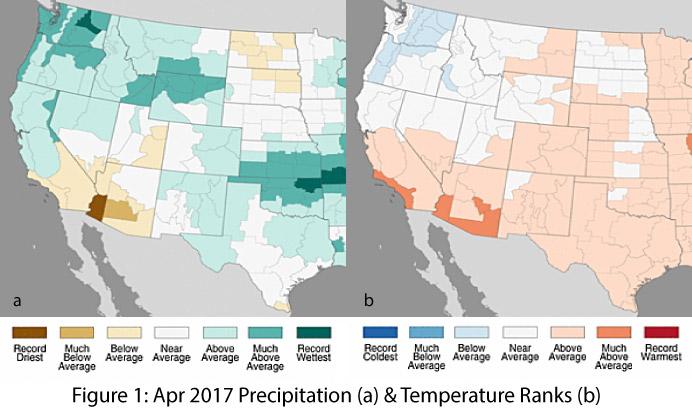
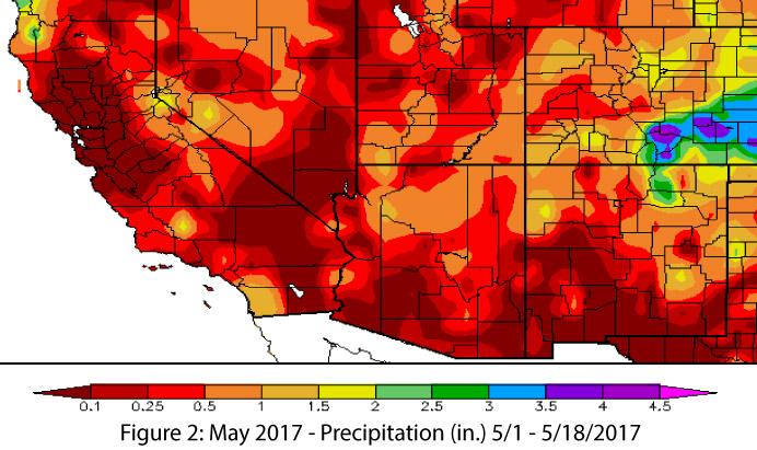
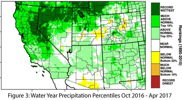
Precipitation & Temperature: April precipitation was average to above average in New Mexico, while most of Arizona was below average, including much-below average and record-dry conditions in the southwestern corner of the state (Fig. 1a). April temperatures were above average in nearly all of Arizona and New Mexico, with much-above average temperatures in southern Arizona (Fig. 1b). May has been dry in southern Arizona and New Mexico, while parts of northern Arizona and northern and eastern New Mexico have picked up decent precipitation relative to the normally dry May climate (Fig. 2). May temperatures in Arizona and New Mexico have ranged from 4 degrees below to 4 degrees above normal, while temperatures in higher latitudes and upper elevations (e.g. Upper Colorado River Basin, California Sierras, etc.) have been generally warmer than average, ranging from 0 to 8 degrees above normal. Water year precipitation has been normal to above normal across most of Arizona and New Mexico aside from a small pocket of dry conditions along the Arizona-Mexico border (Fig. 3).
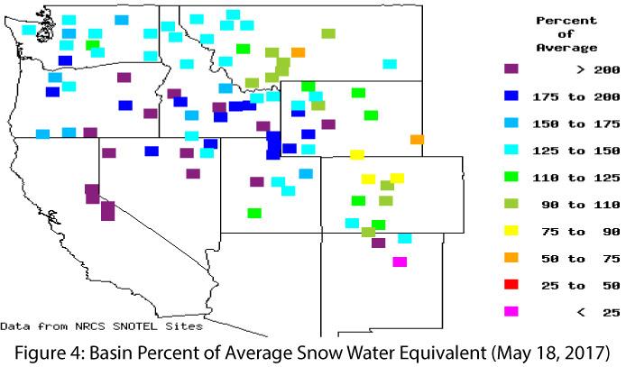
Snowpack & Water Supply: Snowpack and snow water equivalent (SWE) have declined in Arizona and New Mexico as well as in the Upper Colorado River Basin region of Utah and Colorado (Fig. 4). While areas of well-above-average snowpack and SWE remain, particularly in the Great Basin and the California Sierras, persistent warm temperatures are reducing once-impressive snowpack levels back to normal. This has resulted in some remarkable streamflow forecasts, as well as incremental improvements in reservoir storage volumes (see reservoir levels).
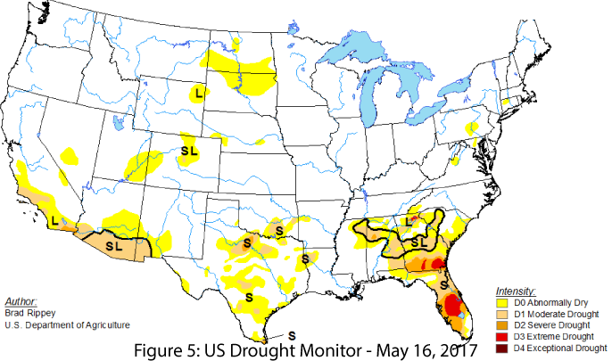
Drought: Much of the West has seen improvements in drought conditions, and only 5.2 percent of the contiguous United States is now designated as experiencing moderate drought (D1) or worse. The wetter-than-normal conditions that helped reduce drought conditions across much of the West (see Fig. 3) provided limited relief (if any) in southern Arizona and New Mexico, which have experienced a return of both short- and long-term drought designations (Fig. 5). These changes are due to both near-record- to record-warm temperatures in recent months and very little precipitation falling since mid-January.
Wildfire, Environmental Health, & Safety: The transition from spring into summer brings rising temperatures, little precipitation, and frequent high winds that create highly favorable conditions for fire ignition and spread. As noted last month, fire managers are increasingly vigilant during this transitional season. This year, fire conditions have been enhanced by the senescence of grasses that thrived under the moisture of last fall and warm temperatures this winter into spring, and have now left behind a pervasive blanket of fine fuels that exacerbate wildfire risks, especially during hot, dry, windy days. The Sawmill fire of 2017 perfectly encapsulates this cluster of conditions (see wildfire report). The warm and dry weather also produces dry and dusty conditions that prompt ongoing health and safety concerns such as dust exposure and traffic visibility.
El Niño Southern Oscillation: Current forecasts suggest ENSO-neutral conditions will continue through the spring and early summer, with approximately equal chances of an El Niño event or ENSO-neutral conditions during the second half of 2017.
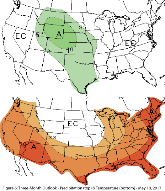
Precipitation & Temperature Forecast: The May 18 NOAA Climate Prediction Center’s outlook for June calls for equal chances of above- or below-average precipitation for most of the Southwest, and increased chances of above-average temperatures across the region. The three-month outlook for June through August calls for equal chances of above- or below-average precipitation in Arizona and much of New Mexico with only the northeast corner of New Mexico expecting increased chances of above-average precipitation (Fig. 6, top). Increased chances of above-average temperatures are forecast for the entire southwestern region (Fig. 6, bottom).

