August 2015 - CLIMAS Southwest Climate Outlook
Precipitation: In the past 30 days, much of southern Arizona and New Mexico received below-average precipitation, with portions of northern Arizona and New Mexico recording above-average precipitation (Fig. 1). In August, below-average precipitation has been punctuated by a few intense storm systems, mostly in Arizona. For New Mexico, July was the 10th wettest month on record. In general, the precipitation events that have occurred have been more localized storm systems, resulting in highly variable precipitation across the region (see Monsoon Tracker, pages 5-6).
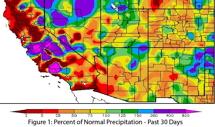 Image Source - High Plains Regional Climate Center
Temperature: After a record warm start to 2015, much of the Southwest cooled off in July, especially in Arizona (Fig. 2). This respite was short-lived however, as temperature anomalies in the past 30 days were between 0 and 6 degrees F above normal across most of New Mexico and most of Arizona (Fig. 3). Globally, 2015 likely will challenge 2014 for warmest year on record, a trend that could affect temperature trends in the Southwest.
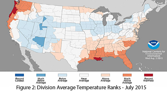
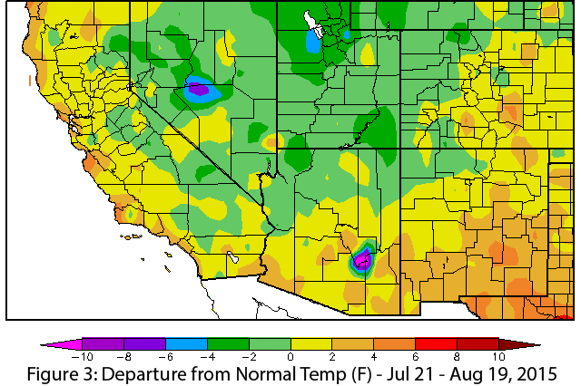 Image Source - High Plains Regional Climate Center
Monsoon: The highly variable nature of the monsoon in terms of when and where rain falls poses a serious challenge to anyone attempting to characterize the monsoon. That said, summer 2015 has been relatively typical, with average to above-average rainfall across much of Arizona and more consistent and sustained above-average precipitation in New Mexico. We also have seen expected breaks in storm activity as the monsoon ridge moves, affecting regional patterns of precipitation—or lack thereof—across the region (see Monsoon Tracker, pages 5–6 for a more detailed discussion).
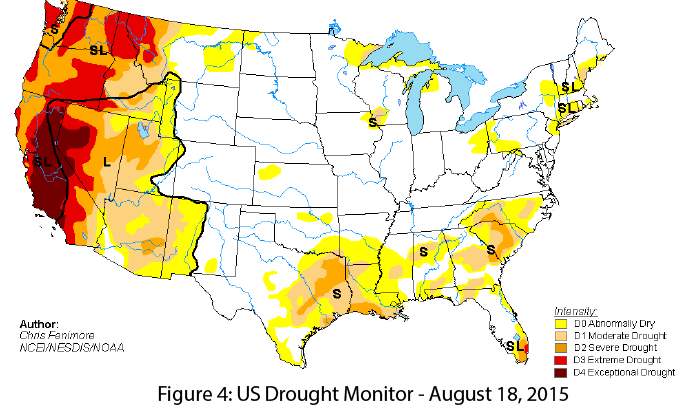
Drought & Water Supply: The U.S. Drought Monitor continues to emphasize drought conditions across the West, with particularly severe conditions in California and Nevada (Fig. 4). Arizona and New Mexico continue to grapple with years of accumulated drought and water deficits, but recent sustained and widespread precipitation has helped slightly scale back drought conditions, particularly in New Mexico (see Reservoir Volumes, page 7).
Wildfire: As of July 31, wildland fires had burned approximately 120,000 acres in Arizona and about 40,000 acres in New Mexico. One notable blaze was the Finger Rock fire, which ignited in the Santa Catalina Mountains in southern Arizona and was visible from Tucson for a number of days. Favorable weather conditions allowed fire managers to let the fire burn out naturally, despite proximity to residential areas. This fire season, well above-average precipitation in Arizona in June and in New Mexico in July tamped down fire risk across the region, resulting in limited regional fire and fire suppression activity, and favorable weather conditions permitted a number of fires to be left to burn, benefitting forest health.
Precipitation & Temperature Forecasts: The Aug. 20 NOAA-Climate Prediction Center seasonal outlook predicts above-average precipitation for most of the Southwest and Intermountain West this summer (Fig. 5, top). Notable exceptions are northern California and far northwestern Nevada. Temperature forecasts are split, with elevated chances for above-average temperatures along the West Coast and into western Arizona (and most of the western U.S.), and increased chances for below-average temperatures centered over Oklahoma and Texas and extending across New Mexico (Fig. 5, bottom). It remains to be seen what effect eastern Pacific tropical storms and El Niño will have on these patterns.
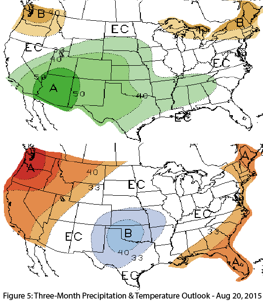 Image Source - NOAA/NWS - Climate Prediction Center
Also in this issue:
- Climate Summary (listed above)
- Maps & Images
- 2015 El Niño Tracker
- Monsoon Summary Jun 15 – Aug 20
- Arizona & New Mexico Reservoir Volumes
