Heat Watch
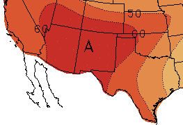
May is normally when temperatures begin to ramp up across the Southwest U.S. and northern Mexico, and that has been the case this year. Several cities along the Rio Grande have set high temperature records, and El Paso and Laredo, TX have already surpassed 100 °F. In early May, Laredo set records with temperatures of 97 °F and 102 °F on May 2nd and 3rd, respectively. A heat wave from May 9-11 set records in Las Cruces, New Mexico (99 °F on May 10th, and 98 °F on May 11th) and El Paso, Texas (100 °F on May 9th, and 101 °F on May 10th). Laredo set another record on May 15th with a high of 100 °F. Looking forward, forecasts indicate that temperatures will be above-average over the next month (Figure 11).
Figure 11 (above): NOAA one-month temperature outlook (June). Forecast made on May 17, 2018 by CPC.
Another heat forecasting tool is now available, produced by the U.S. National Weather Service, that can provide additional insight into near future temperatures in the Southwest U.S. HeatRisk is an experimental forecasting tool that visualizes heat risk potential one-week in advance (Figure 12). It is designed to provide guidance to decision makers and heat-sensitive populations (such as outdoor workers and those with young children) on when to take action in preparation of a heat event. The map is portrayed on a color scale, with each color category representing a different population that is at risk. For example, yellow is a low-level of risk and means that those who are extremely sensitive to heat should take action to prevent illness. When the highest level (magenta) is forecasted, the entire population is at risk due to long-duration heat with little to no relief overnight. HeatRisk can be accessed from the National Weather Service page for most cities (https://www.wrh.noaa.gov/wrh/heatrisk/?wfo=epz).
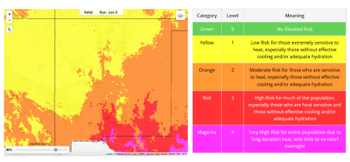
Figure 12 (above): Screenshot of NWS HeatRisk for Sunday, June 3. The table (right) describes the meaning of each color.
Extreme heat causes the most deaths in the U.S. of any weather-related disaster. During this time of year in the Southwest U.S. and northern Mexico, prior to the start of the North American monsoon, it is particularly important to be prepared for the unrelenting heat. Populations at increased risk of heat-related illness include children, pregnant women, elderly, those taking medications, those working outdoors, those with disabilities, those without adequate cooling, and the socially isolated. Be sure to check on loved ones and neighbors and call 911 if anyone is experiencing symptoms of heat stroke (e.g., headache, fast pulse, confusion, nausea, loss of consciousness). For more information on vulnerable populations, the symptoms of heat-related illness, and what to do to prepare, visit the CDC extreme heat webpage (en Espanol: https://www.cdc.gov/es/disasters/extremeheat/index.html).
According to the National Meteorological Service (SMN), in Chihuahua, Mexico, they have reached maximum temperatures of 115 °F (46 °C) at the Urique and San Ignacio stations so far in May 2018, still not reaching historical extreme values.
Positive geopotential height anomalies are correlated with an increase in surface temperature. The high temperatures in Chihuahua are related to the positive anomalies of geopotential height so far in May. In addition, this pattern has prevailed due to La Niña conditions in the winter of 2017-2018.
As mentioned in the seasonal perspective, maximum temperatures may gradually decrease as the start date of the North American monsoon approaches in the northern part of the country.
For June it is expected that on some days maximum temperatures will be higher than 104 °F (40 °C) in all northern Mexico states.