Forecast - September | October | November
Temperature 
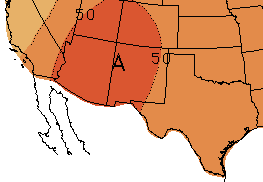
The three-month NOAA temperature outlook (September-November; Figure 5) favors chances for above-average temperatures for all of New Mexico and Texas through November. The one-month outlook also favors chances for above-average temperatures in both states for September (figure not shown).
Figure 5 (right): NOAA three-month temperature outlook (September-November). Forecast made on August 16, 2018 by CPC.
The SMN outlook for September predicts above-average maximum temperatures in Baja California, Chihuahua and Northeast Coahuila, and below-average maximum temperatures for southern Nuevo León and Tamaulipas. For October, SMN predicts above-average anomalies in Northeast Chihuahua, Northwest Coahuila, northern Nuevo León and Tamaulipas, and below-average anomalies in parts of the Baja California peninsula, Sonora and western Chihuahua (Figure 6).
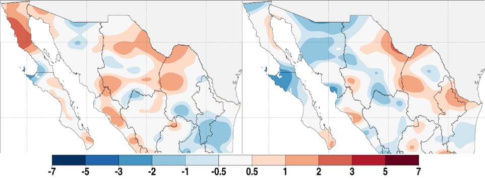
Figure 6 (above): Predicted maximum temperature anomalies for northern Mexico in (°C), September (left) and October (right). Forecast made on August 1, 2018 by SMN.
 This month, we have included an additional forecast commonly used by scientists. The North American Multi-Model Ensemble (NMME) is an experimental seasonal forecasting system that incorporates forecasts from several different runs of individual models, to create a multi-model ensemble of predictions. This method has been shown to produce better prediction quality, on average, than the ensemble of runs from any single model (CPC). The temperature forecast for September-November favors chances for above-average temperatures for the entire Rio Grande-Bravo region (Figure 7).
Figure 7 (above): NMME temperature forecast for September-November. Forecast made by CPC.
Precipitation
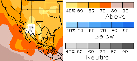
 The NOAA three-month precipitation outlook (September-November; Figure 8) predicts increased chances of above-average precipitation for most of New Mexico and westernmost Texas through November, due to the predicted transition to El Niño during the fall. The forecast calls for equal chances for below-average, average, or above-average precipitation for eastern New Mexico and almost all of Texas through November.
Figure 8 (right): NOAA three-month precipitation outlook (September-November). Forecast made on August 16, 2018 by CPC.
The one-month NOAA outlook (September; figure not shown) shows a pattern of forecast probabilities similar to the three-month outlook, but favoring chances for below-average precipitation across Southeast Texas, and above-average precipitation for all of New Mexico and the Texas panhandle.
For September, the SMN precipitation outlook predicts above-average conditions for southern Baja California Sur, Southeast Sonora, Chihuahua and Durango, and below-average precipitation for Baja California, Northeast Sonora, Nuevo León and Tamaulipas. The precipitation forecast for October favors above-average conditions for the Baja California peninsula, Northwest and southern Sonora, Sinaloa, Durango and parts of Coahuila and Nuevo León, while the rest of the region is expected to experience conditions similar to average (Figure 9).
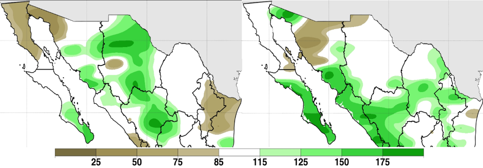
Figure 9 (above): Predicted precipitation anomalies for northern Mexico (in %), September (left) and October (right). Forecast made on August 1, 2018 by SMN.
 NMME forecasts increased chances of above-average precipitation for the entire Rio Grande-Bravo region, for September-November (Figure 10). The forecast likely reflects the predicted transition to El Niño in the fall.
Figure 10 (right): NMME precipitation forecast for September-November. Forecast made by CPC.
Fire
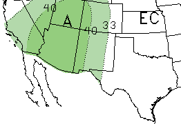
Monsoon precipitation in the Southwest U.S. and northern Mexico in July has eliminated prospects for above-average fire potential across the region, according to the North American Seasonal Fire Assessment and Outlook. Since the end of June, 196 fires burned about 138,000 acres (56,000 hectares) in Mexico. Chihuahua has the most burned area since the beginning of the year, with about 400,000 acres (161,000 hectares) burned. Forecasts for September and October indicate average fire potential for all of the Southwest U.S. and Mexico, except for the Baja California peninsula (Figure 11).
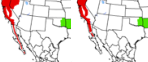
Figure 11 (above): Fire outlook for September (left) and October (right). Red shading indicates conditions that favor increased fire potential. Green shading indicates conditions that favor decreased fire potential. Forecast made on August 13, 2018 from NIFC and SMN.
El Niño-Southern Oscillation (ENSO)
As of mid-July, sea-surface temperatures in the tropical Pacific Ocean were slightly above average, and continue to indicate ENSO-neutral conditions. Neutral conditions are forecast through the summer, with El Niño conditions forecasted to develop by the fall (IRI; NOAA). Chances of El Niño have increased from last month’s forecasts, nearing 65% during the fall and ~70% during winter (Figure 10). There is considerable uncertainty in ENSO forecasts made during the spring, but that barrier has mostly passed and forecasters have come to a consensus that El Niño will develop later this year. If forecasts are correct, chances of a wet winter in the Southwest U.S. and northern Mexico are likely to increase. 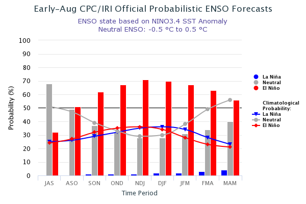
Figure12 (above): Probabilistic ENSO Forecast from IRI.
For more ENSO information:
English: http://iri.columbia.edu/our-expertise/climate/enso/enso-essentials/ y http://www.ncdc.noaa.gov/teleconnections/enso/.
Spanish: http://smn.cna.gob.mx/es/climatologia/diagnostico-climatico/enos y http://www.smn.gov.ar/?mod=biblioteca&id=68