Forecast - February | March | April
Temperature
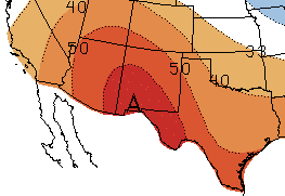
 The three-month NOAA temperature outlook (February-April; Figure 5) favors chances for above-average temperatures for all of New Mexico and Texas through April, reflective of continued La Niña conditions in the tropical Pacific Ocean through the winter.
Figure 5 (right): NOAA three-month temperature outlook (February-April). Forecast made on January 18, 2017 by CPC.
The forecast from CONAGUA´s Servicio Meteorológico Nacional (SMN) for February, predicts minimum temperature conditions with below-average anomalies in the Baja California Peninsula, Northwest Sonora, western Chihuahua and Sinaloa; above-average conditions are expected in Tamaulipas, Nuevo León, Coahuila and Northeast Chihuahua (Figure 6; left). For March the pattern is similar, with SMN predicting below-average minimum temperatures in Baja California, Southeast Chihuahua, western Sonora and Coahuila (Figure 6; right). However above-average anomalies are predicted in Northeast Sonora, Chihuahua, Coahuila, Nuevo León and Tamaulipas.

Figure 6 (above): Predicted minimum temperature anomalies for northern Mexico (in °C) for February (left) and March (right). Forecast made on January 1, 2018 by SMN.
Precipitation
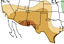
 The NOAA three-month precipitation outlook predicts increased chances for below-average precipitation for all of New Mexico and Texas, except for Northeast Texas (February-April; Figure 7). Precipitation forecasts reflect the projections for continued La Niña conditions in the tropical Pacific Ocean through the winter. La Niña conditions tend to lead to below-average precipitation in the Southwest U.S. and northern Mexico.
Figure 7 (right): NOAA three-month precipitation outlook (February-April). Forecast made on January 18, 2018 by CPC.
For February, the SMN precipitation outlook predicts above-average conditions in Baja California, Chihuahua, Southeast Coahuila and Nuevo León, and below-average conditions in Baja California Sur, Sonora and Coahuila (Figure 8; left). The precipitation forecast for March shows above-average conditions in Southeast Coahuila and Nuevo León, and below-average conditions in the Baja California Peninsula, Sonora, Chihuahua, Southeast Coahuila and eastern Tamaulipas (Figure 8; right).
Figure 8 (above): Predicted precipitation anomalies for northern Mexico (in %) for February (left) and March (right). Forecast made on January 1, 2017 by SMN.
Fire
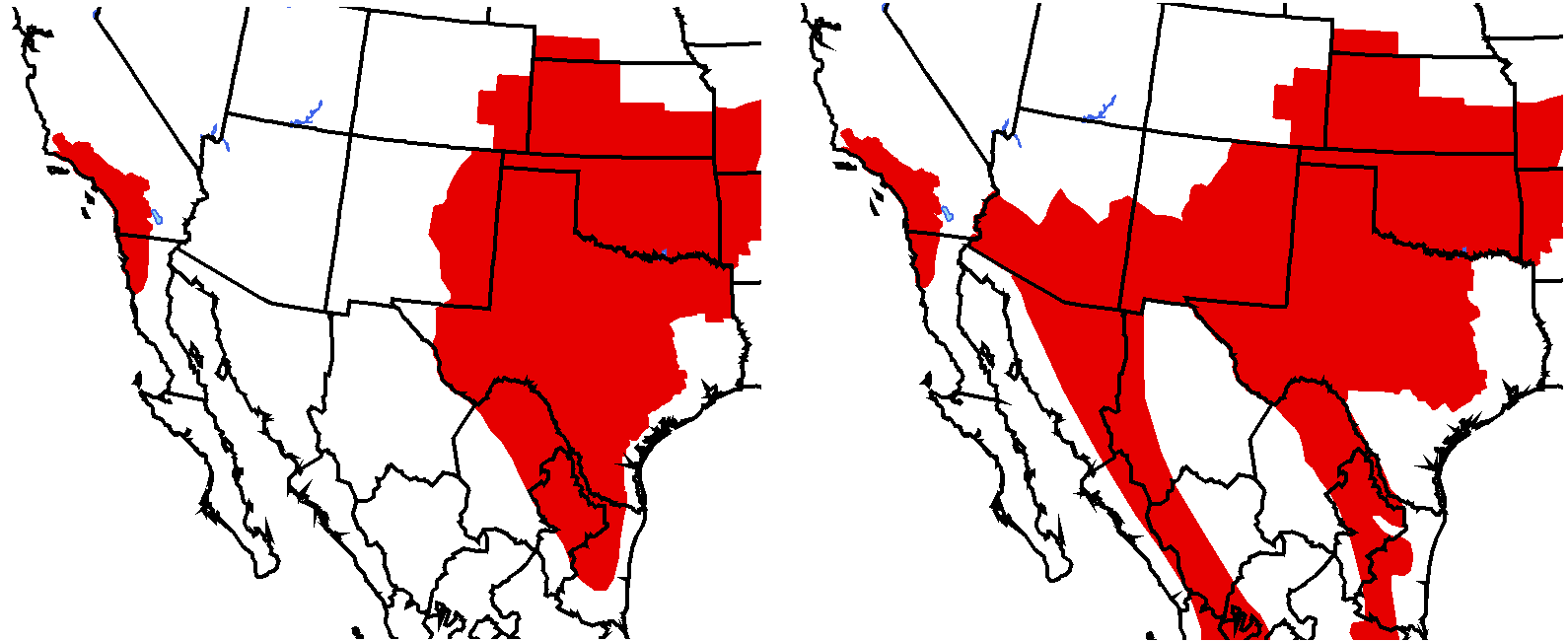
According to the North American Seasonal Fire Assessment and Outlook, fire risk is above average for most of Texas and eastern New Mexico through February, with fire risk expanding westward across New Mexico by March (Figure 9). The increased fire risk is due to continued drying across the region associated with La Niña conditions, coupled with the increasing frequency of wind events common during early spring in the region. In Mexico, forecasts for warm and dry conditions greatly increase fire potential across northeastern Mexico from the Big Bend region to the Gulf Coast through March.
Figure 9 (above): Fire outlook for February (left) and March (right). Red shading indicates conditions that favor increased fire potential. Green shading indicates conditions that favor decreased fire potential. Forecast made on January 15, 2017 from NIFC and SMN.
El Niño-Southern Oscillation (ENSO)

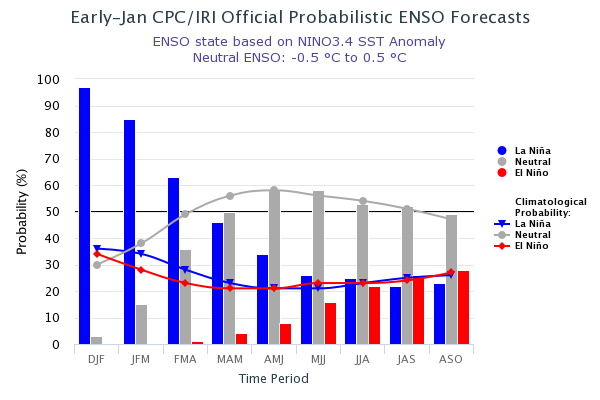
As of early-January, the tropical Pacific Ocean and atmosphere continued to exhibit weak to moderate La Niña conditions (IRI; NOAA). Forecasters believe the La Niña event is currently peaking, and will weaken through the rest of the winter (~85-95%) and then transition to ENSO-neutral conditions during the spring (Figure 10). La Niña events generally lead to above-average temperatures and below-average precipitation in states along the U.S. southern border and in northern Mexico.
Figure 10 (above): ENSO probabilistic forecast from IRI.
For more information in:


