Regional Climate Overview - October | November | December
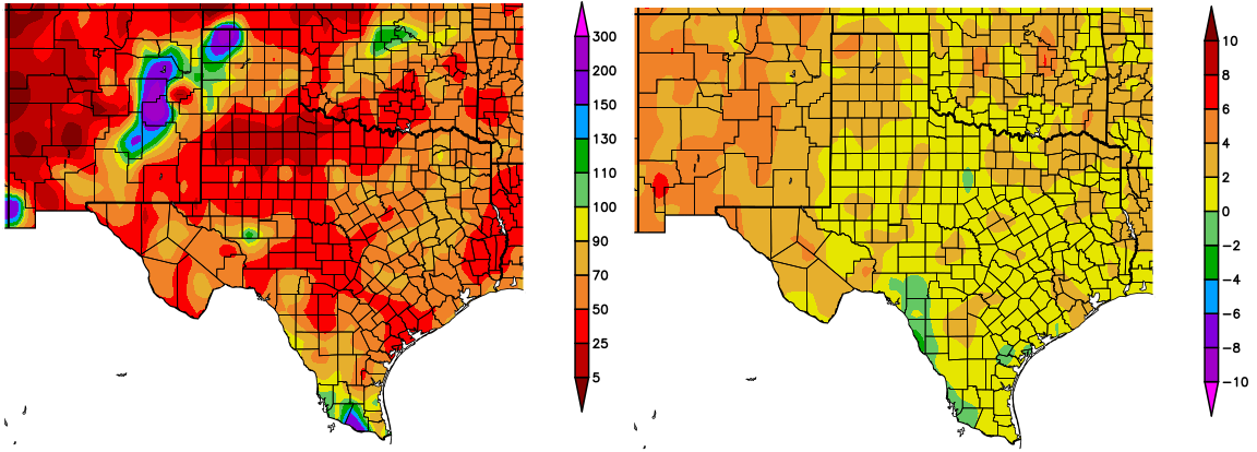
October – December, 2017 precipitation was 0-50% below average for most of New Mexico and 5-90% below average for almost all of Texas. Exceptions were East-Central New Mexico and the extreme northern and southern tip of Texas, where precipitation was above average (Figure 1; left). Temperatures were 2–6 °F (1.1–3.3 °C) above average for New Mexico and 0–4 °F (0–2.2 °C) above average for most of Texas (Figure 1; right).
Figure 1 (above): Percent of average precipitation (left) and departure from average temperature in degrees F (right), compared to the 1981–2010 climate average, for 10/1/2017–12/31/2017. Maps from HPRCC.
Temperatures from January 1–17 were 2–8 °F (1.1–4.4 °C) above average across western New Mexico, and 0–8 °F (1.1–4.4 °C) below average for eastern New Mexico and most of Texas (figure not shown). Precipitation over the same time period was 0–50% below average for almost all of Texas and New Mexico.
Due to two winter storms in December, temperatures were cooler than normal between October-December in northeastern Mexico, a contrast with the northwest part of the country, where warm and dry conditions continued. Anomalies ranged from higher than +5.0 °C (9 °F) in southern Chihuahua to less than -2.0 °C (3.8 °F) in northern Coahuila (Figure 2, left). A higher number of days with minimum temperatures less than or equal to 0 °C (32 °F) were present in Chihuahua-Durango, but snowfall due to winter storms left more than 5 days below this threshold in the Coahuila-Nuevo León border (Figure 2, right).
Figure 2 (above): Temperature anomalies in °C (left) and number of days with minimum temperatures at or below 0 °C (32 °F) (right) for October–December. Maps from SMN.
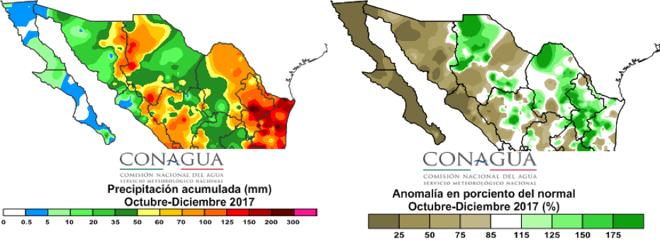
The last quarter of the year, in addition to being cold was also wet, with accumulated greater than 200mm in Nuevo León and Tamaulipas. Elsewhere, accumulated precipitation of about 100mm was observed in the Chihuahua-Sonora and Sinaloa-Durango limits (Figure 3, left). The rest of the northern part of the country ended the year below normal, stressing the Peninsula of Baja California, which experienced precipitation below 25% of average (Figure 3, right).
Figure 3 (above): Accumulated precipitation in mm (left) and percent of normal (right) for October–December. Maps from SMN.
Drought
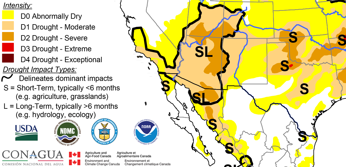
Moderate drought conditions developed in western and northern New Mexico, over the past two months, according to the North American Drought Monitor (NADM) (Figure 4). Moderate to severe drought conditions have also developed in northern and central Texas. Abnormally dry conditions remain present in Tamaulipas. Drought conditions in New Mexico and Texas are predicted to persist, and drought development is likely in southern New Mexico and Southwest Texas, through April, due to continued La Niña conditions in the tropical Pacific Ocean, according to the U.S. Seasonal Drought Outlook.
Figure 4 (above): North American Drought Monitor, released January 11, 2018.


