Regional Climate Overview - June | July | August
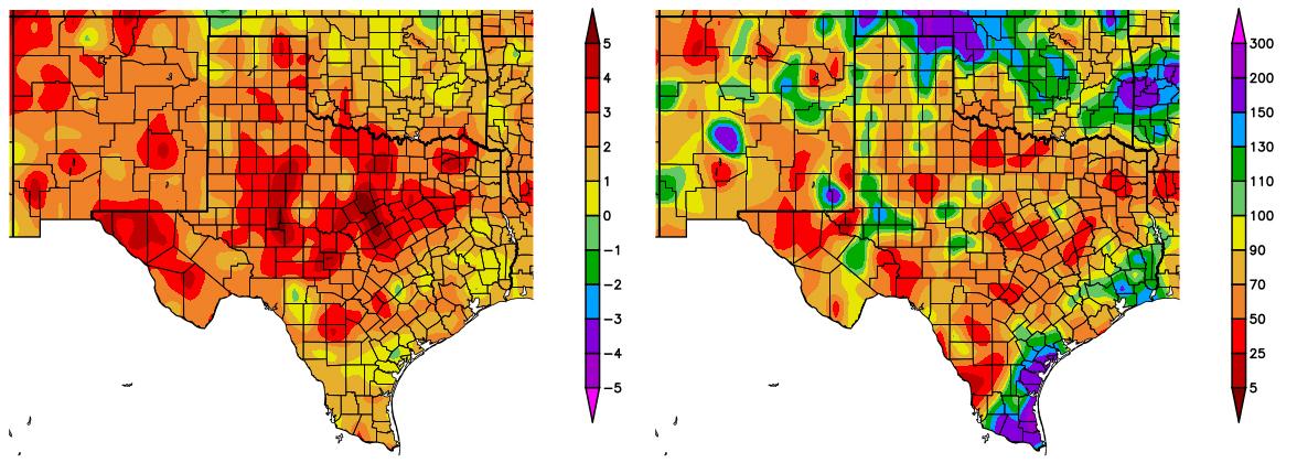
Temperatures over the past three months (June-August) were 2-5 °F (1.1-2.8 °C) above average for most of New Mexico and Texas (Figure 1, left). Precipitation over the same time period was 25-70% of average for most of both states (Figure 1, right). From January-August, New Mexico experienced record warm average and maximum temperatures, and Texas temperatures were much above average (NOAA State of the Climate).
Figure 1 (above): Departure from average temperature in degrees F (left) and percent of average precipitation (right), compared to the 1981–2010 climate average, for 6/1/2018–8/31/2018. Maps from HPRCC.
Temperatures from September 1 through 19 were 0-4 °F (0-2.2 °C) above average in most of New Mexico, and northern, eastern, and westernmost Texas. The rest of Texas experienced temperatures 0-3 °F (0-1.8 °C) below average (figure not shown). Precipitation over the same time period was 200-800% of average for most of Texas, 100-200% for Northeast and Southwest New Mexico, and 5-75% of average for Northwest New Mexico, westernmost Texas, and the Texas panhandle.
From June to August, temperatures continued to be warmer than average over much of Baja California, and the North-Central and Northeast parts of the country. However, the Northwest, mainly Sonora, was again colder than normal. Anomalies greater than 9°F (5°C) above average covered most of Durango and some of Chihuahua, and the Northeast experienced anomalies 3.6–5.4°F (2–3°C) above average (Figure 2, left). The distribution of the number of days with maximum temperatures at or above 104°F (40°C) was similar to the May-July quarter, with the highest number of days (more than 70 days) in the limits of Sonora and Baja California (Figure 2, right).
Figure 2 (above): Temperature anomalies in °C (left) and number of days with maximum temperatures at or above 104 °F (40 °C) (right) for June–August. Maps from SMN.
Monsoon rains continued to be above average in Northwest Mexico in June-August, leading to drought recovery in the region. Greater than 23.6 in (600 mm) accumulated in the limits between Sinaloa-Nayarit and Sonora-Chihuahua (Figure 3, left). Rains were above average in most of Sonora and Chihuahua, but the Northeast continued to be dry for another quarter (Figure 3, right).
Figure 3 (left): Accumulated precipitation in mm (left) and percent of normal (right) for June–August. Maps from SMN.
Drought
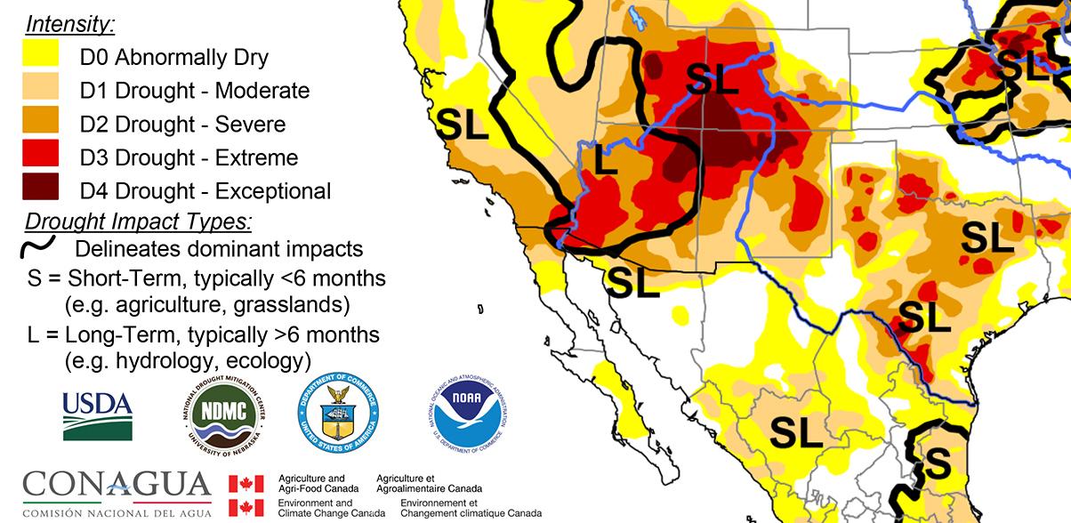
Drought conditions persisted at levels similar to last month in New Mexico and Texas, according to the North American Drought Monitor (NADM) (Figure 4). Severe to exceptional drought still covers over half of New Mexico. In Texas, severe to extreme drought conditions persist, mostly in the central portion of the state, and near Laredo. In Mexico, moderate drought conditions developed in southern Chihuahua and Coahuila, and in Tamaulipas and Nuevo León. Drought conditions are predicted to continue, but decrease in severity across most of New Mexico and the Texas panhandle, by the end of November, according to the U.S. Seasonal Drought Outlook. In southern New Mexico, drought is likely to dissipate during this time. For Central, Northeast, and Southwest Texas, drought conditions are predicted to persist.
Figure 4 (above): North American Drought Monitor, released September 12, 2018.


