Forecast - July | August | September
Forecast - July | August | September
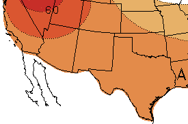 The three-month NOAA temperature outlook (July-September; Figure 5) favors chances for above-average temperatures for all of New Mexico and Texas through September. The one-month outlook favors chances for above-average temperatures in most of Texas and equal chances for below-average, average, or above-average temperatures for New Mexico and West Texas for July (figure not shown).
Figure 5 (right): NOAA three-month temperature outlook (July-September). Forecast made on June 21, 2018 by CPC.
The forecast from CONAGUA´s Servicio Meteorológico Nacional (SMN) for July predicts above-average maximum temperatures in the Baja California Peninsula, middle and southern Chihuahua, Coahuila, Nuevo León and Tamaulipas (Figure 6; left). Below-average anomalies are predicted for Northwest and southern Sonora. For August, forecasts predict above-average anomalies in Tamaulipas, Nuevo León and Coahuila, and below-average anomalies in some areas of the Baja California Peninsula and Chihuahua (Figure 6; right).
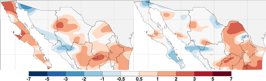
Figure 6 (above): Predicted maximum temperature anomalies for northern Mexico in (°C), July 2018 (left) and August 2018 (right). Forecast made on June 1, 2018 by SMN.
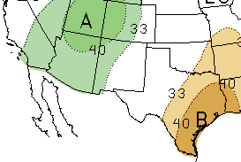 The NOAA three-month precipitation outlook (July-September; Figure 7) predicts equal chances for below-average, average, or above-average precipitation for the eastern half of New Mexico and the western half of Texas through September. Forecasts also favor increased chances of below-average precipitation for eastern and southern Texas during the same time period, and above-average precipitation for the wetern half of New Mexico, due to the predicted transition to El Niño during the summer and fall. The one-month NOAA outlook (July; figure not shown) shows a pattern of forecast probabilities similar to the three-month outlook.
Figure 7 (above): NOAA three-month precipitation outlook (July-September). Forecast made on June 21, 2018 by CPC.
For July, the SMN precipitation outlook predicts above-average precipitation in Sonora, northern Baja California, and some regions of Chihuahua, and below-average precipitation in Tamaulipas, Nuevo León, Coahuila, eastern Chihuahua and the rest of the Baja California Peninsula (Figure 8; left). The precipitation forecast for August shows above-average precipitation in some regions of the Baja California Peninsula, Sonora and Chihuahua, and below-average precipitation in Tamaulipas, Nuevo León, Coahuila, eastern and Northeast Chihuahua, Northeast and Northwest Sonora and northern Baja California (Figure 8; right).
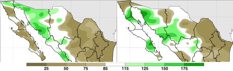
Figure 8 (above): Predicted precipitation anomalies for northern Mexico (in %), June 2018 (left) and July 2018 (right). Forecast made on June 1, 2018 by SMN.
Fire
According to the North American Seasonal Fire Assessment and Outlook, windy and dry conditions in New Mexico and West Texas helped drive fire growth in both states over the past month. Since early May, over 247,000 acres (100,000 hectares) burned in Mexico, with Chihuahua, Jalisco, and Durango experiencing the greatest burned areas. Summer monsoon rains moving in to the Southwest U.S. and northern Mexico in July and August are anticipated to mitigate fire conditions. Forecasts for July and August indicate normal fire potential for all of the Southwest U.S. and Mexico, except for Baja California.
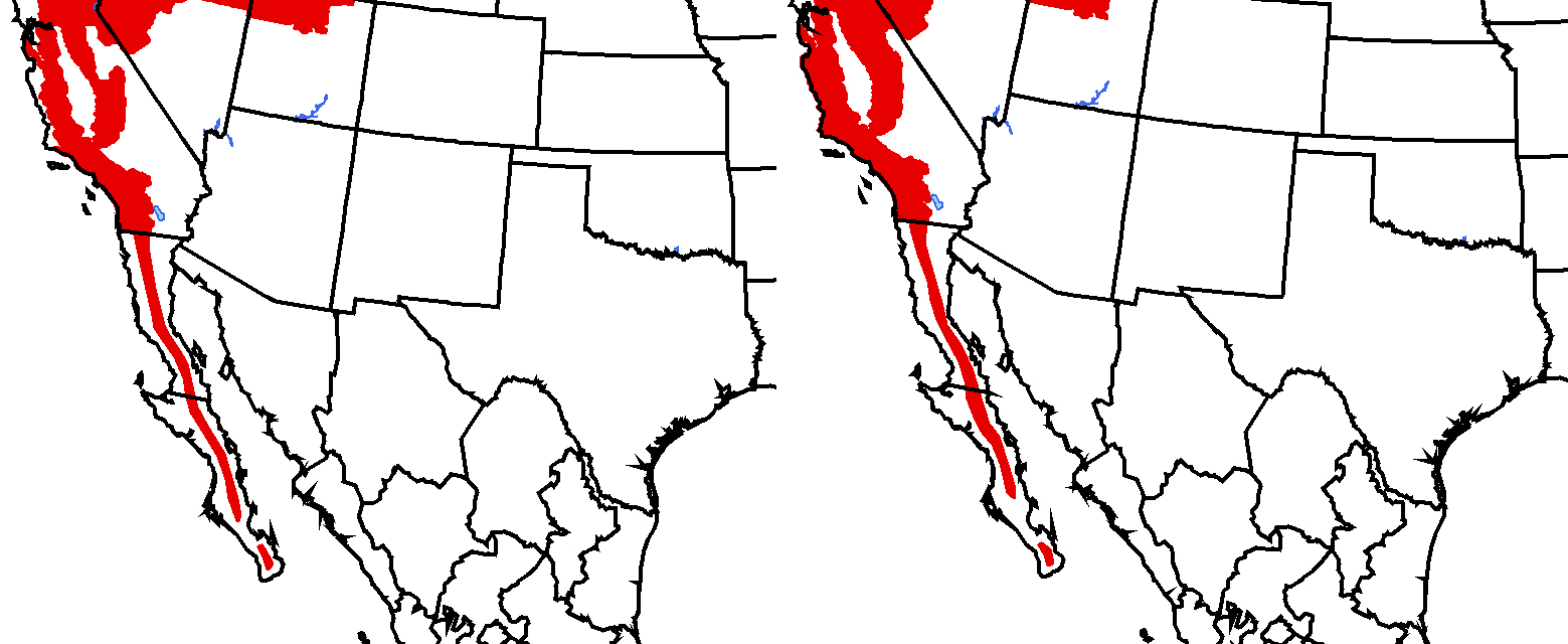 Figure 9 (above): Fire outlook for July (left) and August (right). Red shading indicates conditions that favor increased fire potential. Green shading indicates conditions that favor decreased fire potential. Forecast made on June 11, 2018 from NIFC and SMN.
El Niño-Southern Oscillation (ENSO)
As of mid-June, sea-surface temperatures and atmospheric conditions in the tropical Pacific Ocean continue to indicate ENSO-neutral conditions. An ongoing build-up of heat in the tropical Pacific is leading to predictions of El Niño conditions by the fall (IRI; NOAA). Neutral conditions are forecasted to persist through the summer, and chances of El Niño have increased from last month’s forecasts, nearing 50% during the fall and ~65% during winter (Figure 10). There is considerable uncertainty in ENSO forecasts made during the spring, but that barrier has mostly passed and forecasters have come to a consensus that El Niño will develop later this year. If forecasts are correct, chances of a wet winter in the Southwest U.S. and northern Mexico are likely to increase.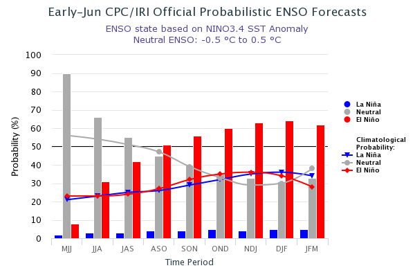
Figure10 (above): Probabilistic ENSO Forecast from IRI.
For more ENSO information:
English: http://iri.columbia.edu/our-expertise/climate/enso/enso-essentials/ y http://www.ncdc.noaa.gov/teleconnections/enso/.
Spanish: http://smn.cna.gob.mx/es/climatologia/diagnostico-climatico/enos y http://www.smn.gov.ar/?mod=biblioteca&id=68